
Bittelschießer cave
| Bittelschießer cave
|
||
|---|---|---|
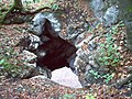
 The entrance to the Bittelschießer cave |
||
| Location: | Swabian Alb , Germany | |
| Height : | 610 m above sea level NN | |
|
Geographic location: |
48 ° 6 '24 " N , 9 ° 15' 22.5" E | |
|
||
| Cadastral number: | 7821/04 | |
| Geology: | Mass limestone of the Upper Jura | |
| Type: | Karst cave | |
| Overall length: | 64 meters | |

The Bittelschießer Höhle is a natural cave in the upper mass limestone southeast of Hornstein in the municipality of Bingen in the district of Sigmaringen in Baden-Württemberg , Germany .
location
The cave upstream and southwest of Bingen is located in the Bittelschießer Täle , a 300 meter long rock gorge in the mass limestone of the Upper Jura, a section of the Lauchert valley , at around 605 meters above sea level . The Lauchert's bed itself is around 603 meters above sea level. The ruins of Hornstein Castle are around a kilometer north of it . Above the cave is the Bittelschieß ruin ; it is not far from the Lauchertbrücke (footbridge).
description
The cave is 64 meters long and in the main passage 9 meters wide and 14 meters high. It is a typical karst cave with corroded forms and crevices . At the end of the main corridor, to the right of the shard silt, you can get to the upper floor, whose corridor ends in the middle of the main corridor. From the upper floor there is another shaft leading upwards at an angle. The cave is open from the Lauchert side (south side).
The cave is protected as a geotope under the name Bittelschießer Täle & Höhlen .
Emergence
The cave in the Bittelschießer Täle was created by the Lauchert after the crack ice age . Until then, the original Danube flowed through today's Laucherttal near Bingen . Its valley was covered with moraine debris by the Riss-Ice Age Rhine glacier, which was later largely cleared again by the Lauchert, while the Danube found a new bed about five kilometers south after the retreat of the glaciers. Therefore, the Lauchert "accidentally" cut one of the old loops of the former Danube valley in the Bittelschießer Täle. There are other small caves (around Bittel shooter Half Cave , Chapel cave , bridge cave , root cavity ). The Bittelschießer Höhle is registered as a natural monument with the Freiburg Regional Council.
gallery
Rock hole (upper entrance to the cave)

View from the cave into the Bittelschießer Täle

The Lauchert in the Bittelschießer Täle

Chapel of Bittelschieß Castle, above the cave


annotation
- ↑ LGRB-Id: 6197
See also
literature
- Thomas Striebel, Klaus Striebel: The Bittelschießer Täle and its caves . In: Bulletin of the Blaustein cave research group . 4th year. Issue 1. Hemsbach 1981. pp. 58ff.
- Hans Binder , Herbert Jantschke: Cave guide Swabian Alb. Caves - springs - waterfalls . 7th completely revised edition. DRW-Verlag, Leinfelden-Echterdingen 2003, ISBN 3-87181-485-7 , p. 253 .