
Cheeks (Ostrach)
|
Cheeks
municipality Ostrach
|
|
|---|---|
 |
|
| Height : | 597 m above sea level NHN |
| Area : | 2.83 km² |
| Residents : | 139 (Jul 31, 2014) |
| Population density : | 49 inhabitants / km² |
| Incorporation : | 1st December 1971 |
| Postal code : | 88356 |
| Area code : | 07585 |
 Cheeks (front left, right Jettkofen )
|
|
Wangen is one of eight localities in the Baden-Württemberg community of Ostrach in the Sigmaringen district in Germany .
geography
Geographical location
Wangen is located around three and a half kilometers northwest of the main town of Ostrach in the Ostrach valley , between the villages of Jettkofen in the southeast and Weithart in the north.
Expansion of the area
The total area of the district of Wangen covers around 283 hectares (as of December 31, 2010).
history
In 799, a monk from the Reichenau monastery first mentioned a property in what is now Wangen. Wangen was first mentioned in a document in 1187, the place belonged to the county of Heiligenberg.
Knight Berthold von Urach bought the Kelnhof in Wangen from Reichenau Monastery with Abbot Diethelm von Castell in 1324 , and in November of the same year Wangen came to the County of Sigmaringen. Wangen came to Heiligenberg in 1463, in 1534 with the county of Sigmaringen as an Austrian fiefdom to Karl von Hohenzollern , and in 1540 to Friedrich von Fürstenberg .

In 1806, as part of the reorganization during the Napoleonic period , Wangen became a Baden exclave in the midst of the Hohenzollern and Württemberg communities. In 1843 Wangen came to the Pfullendorf district office and in 1936 to the Überlingen district .
In anticipation of the administrative reform, Wangen came to the Sigmaringen district in 1969 .
As part of the regional reform in Baden-Württemberg , Wangen was incorporated into Ostrach on December 1, 1971.
Population development
The table shows the population development of Wangen.
| around 1660 |
1961 | 1971 | 2012 (December 31) |
2014 (July 31) |
| 11 | 156 | 167 | 145 | 139 |
Place name
In 1248 the place name Wangin appeared , in 1468 Wanggen . The word cheeks comes from " Wang " (= plain, field, naturally green, flat terrain).
politics
Mayor
Mayor of Wangens is Franz Steinhart.
coat of arms
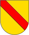
The coat of arms of the former municipality of Wangen shows a natural plow in silver on a green shield base , according to another source, a silver plow in blue on a red shield base .
Culture and sights
Buildings
- The Sankt-Michaels-Kapelle is a Romanesque building from the 12th century . After being damaged during the Thirty Years' War , the chapel was repaired again in 1676 in 1895 and renovated in 1959. The bell, which was purchased in 1900, also called the weather bell , was rung when severe thunderstorms with storms and hail were approaching and called on the villagers to light the weather candle and to pray for God's protection for people, animals and the yard. Otherwise the bell was rung by hand regularly three times a day. This situation changed during the tenure of pastor and chamberlain Georg Moser, who had an electrical bell system installed in 1963.
- Around 500 meters northwest of Wangen on the 620 m above sea level. NN high "Leiterberg" is the location of the castle Leiterberg . Only a few remains of the abandoned Spornburg can be found today.
Tri-border region
On the edge of the Bühl , southwest of Wangen ( coordinates ), there was one of four three-country corners in the Ostrach district in 1806 , the suburbs of which were in Baden , Hohenzollern and Württemberg , where the three countries met a common border point. This point is marked by a border post with a sign from the Ostrach Border Stone Museum and the three coats of arms of the former countries. The other three-country corners are at Magenbuch , Laubbach and Jettkofen .
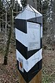
Border post
to bathe
Hohenzollern

Württemberg


Economy and Infrastructure
Citizen bus

The Ostracher Citizens' Bus complements local public transport and improves, among other things, the mobility of people with disabilities. The bus runs three days a week according to a fixed schedule between the center of Ostrach and Jettkofen, Wagen, Bernweiler, Einhart, Levertsweiler, Lausheim and Magenbuch.
The citizen bus is financed by the municipality of Ostrach and operated by the citizen bus association as well as volunteer drivers and helpers.
literature
- Josef Mühlebach: Wangen im Ostrachtal - From the history of the village up to 1968 . In: Hohenzollerischer Geschichtsverein (Hrsg.): Hohenzollerische Heimat, 22nd year, no. 2 , pp. 24–26.
Web links
Individual evidence
- ↑ Wangen on the website of the municipality of Ostrach , accessed on March 9, 2015
- ↑ Top25 Viewer [Top. Map 1: 100000 Baden-Württemberg]
- ↑ Information from the municipality of Ostrach from January 11, 2011.
- ↑ See the state of Baden-Württemberg. Official description by district and municipality. Volume VII: Tübingen administrative region. ed. from D. Landesarchivdirektion Baden-Württemberg, Verlag W. Kohlhammer, Stuttgart 1978, ISBN 3-17-004807-4 . P. 783.
- ^ Franz Steinhart: Description of the history of Wangen , accessed on March 9, 2015
- ↑ Information from the municipality of Ostrach in the Ostrach Border Stone Museum
- ^ Numbers and facts of the community of Ostrach
- ↑ Josef Unger (ugr): Service in the chapel for 40 years . In: Südkurier of March 15, 2011
- ↑ Information board of the Ostrach boundary stone museum on the surveying trail
- ↑ Flyer of the municipality of Ostrach: "CITIZEN BUS CONNECTS - CITIZENS DRIVE CITIZENS", November 2014
Locations: Burgweiler | Jettkofen | Kalkreute-Spöck | Laubbach | Stomach book Lausheim | Tafertsweiler | Cheeks | Far hard
Sub-locations: Bachhaupten | Bernweiler | Flugglers | Egg mill | Einhart | Eschendorf | Gunzenhausen | Habsthal | Rooster Nest | Kalkreute | Laubbach | Lausheim | Levertsweiler | Stomach book | Mettenbuch | Oberochsenbach | Oberweiler | Ochsenbach | Spöck | Tafertsweiler | Ulzhausen | Unterweiler | Waldbeuren | Wirnsweiler | Zoznegg
Hamlet: Dichtenhausen | Freudenberg | Rothenbuehl