
Überlingen district
| coat of arms | Germany map | |
|---|---|---|

|
Coordinates: 47 ° 50 ' N , 9 ° 15' E |
|
| Basic data (as of 1972) | ||
| Existing period: | 1938-1972 | |
| State : | Baden-Württemberg | |
| Administrative region : | South Baden | |
| Administrative headquarters : | Überlingen | |
| Area : | 566 km 2 | |
| Residents: | 73,202 (May 27, 1970) | |
| Population density : | 129 inhabitants per km 2 | |
| License plate : | OV | |
| Circle key : | 08 3 45 | |
| Circle structure: | 66 parishes | |
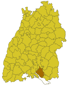
| Location of the district of Überlingen in Baden-Württemberg | ||
  |
||

The district of Überlingen was a district in Baden-Württemberg that was dissolved in the course of the district reform on January 1, 1973 .
geography
location
The district of Überlingen was in the south of Baden-Württemberg .
Geographically, the district of Überlingen had a share in the Hegau and Linzgau . The district town of Überlingen was in the southwest of the district.
Neighboring areas
Its neighboring districts were the Stockach , Sigmaringen , Ravensburg and Tettnang districts , starting clockwise in 1972 . In the south, Lake Constance formed its natural border.
history
Before 1800, the area of the later district of Überlingen belonged to various dominions, including the princes of Fürstenberg . In 1810, the area came to Baden , which initially formed several offices , including the offices or district offices of Heiligenberg, Herdwangen, Meersburg, Pfullendorf , Salem and Überlingen, which changed several times over the course of history and some were soon dissolved. They belonged to the Seekreis in the state commissioner district of Konstanz . In 1849 the Heiligenberg District Office and in 1857 the Salem District Office were abolished. The two remaining offices of Überlingen and Pfullendorf were merged in 1936 to form the office of Überlingen. This resulted in the Überlingen district in 1939.
After the formation of the state of Baden-Württemberg in 1952, the district of Überlingen belonged to the administrative district of South Baden . In the run-up to the district reform or the community reform from 1971, the district area changed in five cases: On January 1, 1969, the Adelsreute community was assigned to the Ravensburg district, where it was incorporated into the city of Ravensburg five years later (October 1, 1974) . At the same time, on January 1, 1969, the Gaisweiler community moved from the Sigmaringen district to the Überlingen district. On December 1, 1971, the municipality of Raderach and on April 1, 1972 the municipality of Kluftern merged with the city of Friedrichshafen, Tettnang district , so both communities left the Überlingen district. On December 1, 1971, the municipality of Wangen was incorporated into the municipality of Ostrach, Sigmaringen district, and thus also left the Überlingen district.
With effect from January 1, 1973, the Überlingen district was dissolved. Most of its communities merged into the new Lake Constance district , which became the legal successor to the Überlingen district. The communities in the northern district were incorporated into the enlarged Sigmaringen district. Since then, all communities in the former Überlingen district have belonged to the Tübingen district .
Population development
All population figures are census results.
|
|
politics
District Administrator
The senior officials or district administrators of the district office or district of Überlingen 1803–1972:
- 1803–1807: Josef Edler von Chrismar
- 1807–1820: Johann Baptist Ehren
- 1820–1825: Philipp Josef Hager
- 1825–1830: Marquard von Chrismar
- 1830–1839: Konrad Böttlin
- 1839–1843: Josef Bleibimhaus
- 1843–1849: Hermann Faber
- 1849–1862: Mathias Martin
- 1862–1864: Hermann Winnefeld
- 1864–1874: Otto Scherer
- 1874–1877: Rudolf Rüdt von Collenberg-Eberstadt
- 1877–1880: Heinrich Pfister
- 1880–1890: Ludwig Salzer
- 1890–1893: Wilhelm Haape
- 1893–1900: Wilhelm Groos
- 1900–1908: Otto von Senger
- 1908–1930: Hermann Levinger
- 1931–1934: Kurt Sander
- 1934–1945: Rudolf Maier
- 1945–1948: Franz Illner
- 1948–1949: Herbert Hassencamp-Fischer (clerk)
- 1949–1955: Georg Beck
- 1956–1972: Karl Schiess
coat of arms
The coat of arms of the district of Überlingen showed in a shield diagonally divided by silver and blue above a black stepped sloping bar, below a silver fish sloping downwards. The coat of arms was awarded by the Ministry of the Interior of Baden-Württemberg on October 16, 1958.
The sloping beam symbolizes the "Heiligenberger Stiege", the coat of arms of the Counts of Heiligenberg , who ruled the Linzgau, which essentially coincides with the district area. They were inherited by the Counts of Werdenberg and these in turn by the Princes of Fürstenberg. The fish symbolizes Lake Constance and stands for the once important fishing in the region.
Economy and Infrastructure
traffic
There was no federal motorway running through the district . Therefore, the district was opened up by the federal highway 31 and several district roads.
Communities
From 1936 onwards, there were 66 municipalities in the Überlingen district, four of them towns.
On March 7, 1968, the state parliament of Baden-Württemberg set the course for a community reform . With the law to strengthen the administrative power of smaller municipalities , it was possible for smaller municipalities to voluntarily unite to form larger municipalities. The beginning in the district of Überlingen was made on July 1, 1971 by the municipality of Bambergen, which merged with the city of Überlingen . In the period that followed, the number of communities steadily decreased until the Überlingen district was finally dissolved on January 1, 1973.
The largest municipality in the district was the district town of Überlingen. The smallest communities were Roggenbeuren (in 1961) and Gaisweiler, which was only reclassified in 1969 (in 1970).
In the table, the municipalities of the Überlingen district are before the municipal reform. The population figures refer to the census results in 1961 and 1970.
Footnotes:
1 Adelsreute was a Baden exclave in the Überlingen district, which was reclassified to the Ravensburg district on January 1, 1969.
2 Gaisweiler was a Hohenzollern exclave of the Sigmaringen district, which was reclassified to the Überlingen district on January 1, 1969.
3 Wangen was a Baden enclave of the Überlingen district, which was reclassified to the Sigmaringen district on January 1, 1969.
License Plate
On July 1, 1956, the district was assigned the distinctive sign ÜB when the vehicle registration number that is still valid today was introduced . It was issued until December 31, 1972.
On October 16, 2019, the district council of the Lake Constance district approved the reintroduction of the old license plates ÜB and TT (Tettnang) in the fourth attempt, and a little later the district of Ravensburg. ÜB has been issued in the Lake Constance district since February 3, 2020, and also in the Ravensburg district from July 22, 2020.
literature
- Überlingen district. (= The city and rural districts of Baden-Württemberg in words and numbers; Issue 14) . Published by the Ministry of the Interior and Ministry of Economics in Baden-Württemberg, processing and printing of the State Statistical Office of Baden-Württemberg, Stuttgart, 1965.
Individual evidence
- ↑ a b Federal Statistical Office (ed.): Historical municipality register for the Federal Republic of Germany. Name, border and key number changes in municipalities, counties and administrative districts from May 27, 1970 to December 31, 1982 . W. Kohlhammer, Stuttgart / Mainz 1983, ISBN 3-17-003263-1 , p. 503 f .
- ↑ www.suedkurier.de
.svg)
Basking | Backnang | Baden-Baden | Balingen | Biberach | Boeblingen | Bruchsal | Book | Bühl | Calw | Crailsheim | Donaueschingen | Ehingen | Emmendingen | Esslingen | Freiburg (city) | Freiburg (State) | Freudenstadt | Friedrichshafen | Göppingen | Hechingen | Heidelberg (city) | Heidelberg (Country) | Heidenheim | Heilbronn (city) | Heilbronn (Land) | Black Forest | Horb | Karlsruhe (city) | Karlsruhe (State) | Throat | Constance (city) | Constance (Country) | Künzelsau | Lahr | Leonberg | Loerrach | Ludwigsburg | Mannheim (city) | Mannheim (State) | Mergentheim | Mosbach | Muellheim | Münsingen | Neustadt | Nürtingen | Offenburg | Öhringen | Pforzheim (city) | Pforzheim (Country) | Rastatt | Ravensburg | Reutlingen | Rottweil | Säckingen | Saulgau | Schwäbisch Gmünd | Schwäbisch Hall | Sigmaringen | Sinsheim | Stockach | Stuttgart | Tauberbischofsheim | Tettnang | Tübingen | Tuttlingen | Überlingen | Ulm (city) | Ulm (State) | Vaihingen | Villingen | Villingen-Schwenningen | Waiblingen | Waldshut | Cheeks | Wolfach