
Brook heads
|
Brook heads
municipality Ostrach
Coordinates: 47 ° 59 ′ 0 ″ N , 9 ° 25 ′ 49 ″ E
|
|
|---|---|
| Height : | 634 m above sea level NHN |
| Postal code : | 88356 |
| Area code : | 07585 |
Bachhaupten is a suburb of Tafertsweiler , one of eight localities in the Baden-Württemberg community of Ostrach in the Sigmaringen district .
geography
Geographical location
The suburb of Bachhaupten lies at an altitude of 634 m above sea level. NHN , 4.9 kilometers northeast of the center of Ostrach, between Tafertsweiler in the southwest, Eschendorf in the northwest, Wirnsweiler in the southeast and the Brühl ( 656.8 m above sea level ) in the east.
history
Parts of the Ostrachgau were owned by the last barons' son, Bertold von Bachobiten (Bachhaupten), who died as a monk in the Salem monastery . In 1175, Salem acquired Bachhaupten, Tafertsweiler and Eschendorf by will or purchase. In 1200, with the approval of Counts Konrad and Heinrich von Wartenberg, the possessions of Messrs Haller zu Gunzenhausen came to Salem. Thus the places Bachhaupten, Tafertsweiler, Eschendorf and Gunzenhausen formed the first Salemische Amt in Ostrachgau - the Amt Bachhaupten.
In 1603 the office of Bachhaupten was moved to the market town of Ostrach and was called Oberamt Ostrach. The secular bailiff was now in Ostrach, the clergyman, a priest, stayed in the castle at Bachhaupten as prefect and representative of the imperial abbot of Salem.
In the 19th century, Bachhaupten formed an independent community association with Tafertsweiler, Eschendorf and Gunzenhausen. In 1806 the village came to Hohenzollern-Sigmaringen and with this in 1850, as part of the Hohenzollern Lands, to Prussia .
As part of the regional reform in Baden-Württemberg , the municipality of Tafertsweiler was incorporated into Ostrach on October 1, 1974 with the town of Bachhaupten.
Culture and sights
Place-name sign
A renovated historical place-name sign from 1867 has been standing on Mühlbachstrasse since 1984. At that time, Bachhauptens belonged to the Oberamt and registration office in Sigmaringen as well as to the Landwehr district of Coblenz .
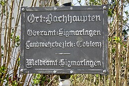
Historical place-name sign

St. Michael

Portal of the former monastery wall
with Salem coat of arms


Buildings
St. Michaelis Church
The Sankt Michaels Church was built in 1727/28 in the early Rococo style under Abbot Constantinus von Salem ( Konstantin Miller ) by master builder Johann Georg Widemann from Elchingen . The tower shaft remained from the medieval predecessor church.
Salem care center Bachhaupten
In 1175 the Salem monastery acquired properties in Bachhaupten, which it had managed by lay brothers , and even before 1183 the noble free Bertolf von Bachhaupten gave the monastery the church and place. From the 13th century to 1705 the monastic official seat was here, the administrative office for the Salem possessions on the right of the Ostrach . The nursing home building and the monastery wall were built around 1700. In 1803 the Salem Monastery was abolished, Bachhaupten fell to the Prince of Thurn und Taxis , and the farm became private property. 1972 the courtyard and the wall were demolished; Part of the wall with the portal can still be seen today above the church, at the end of the street Klosterhof .
Economy and Infrastructure
Citizen bus

The Ostracher Citizens' Bus complements local public transport and improves, among other things, the mobility of people with disabilities. The bus runs three days a week according to a fixed schedule between the center of Ostrach and Tafertsweiler, Eschendorf, Bachhaupten and Wirnsweiler.
The citizen bus is financed by the municipality of Ostrach and operated by the citizen bus association as well as volunteer drivers and helpers.
Personalities
Sons and daughters of the place
- Balthasar Puolamer (1615–1681), born in Bachhaupten, nineteenth abbot of the Imperial Abbey of Ochsenhausen
- Reinhold Frank (1896-1945), born in Bach Berghaupten, lawyer, resistance fighter against the Nazis , was executed after the failed Hitler - assassination on 20 July 1944
Web links
- The suburb of Bachhaupten near the village of Tafertsweiler on the website of the municipality of Ostrach
- Private website for the suburb of Bachhaupten
Individual evidence
- ^ The localities of Ostrach ; Retrieved February 9, 2015
- ↑ Top25 Viewer [Top. Map 1: 100000 Baden-Württemberg]
- ↑ a b Josef Unger (ugr): Ostrach under the rule of the Salem Imperial Abbey. In: Südkurier of October 27, 2010
- ↑ Information from the municipality of Ostrach in the Ostrach Border Stone Museum
- ^ Federal Statistical Office (ed.): Historical municipality directory for the Federal Republic of Germany. Name, border and key number changes in municipalities, counties and administrative districts from May 27, 1970 to December 31, 1982 . W. Kohlhammer, Stuttgart / Mainz 1983, ISBN 3-17-003263-1 , p. 549 .
- ↑ Information board on the former monastery wall
- ↑ Flyer of the municipality of Ostrach: "CITIZEN BUS CONNECTS - CITIZENS DRIVE CITIZENS", November 2014
Locations: Burgweiler | Jettkofen | Kalkreute-Spöck | Laubbach | Stomach book Lausheim | Tafertsweiler | Cheeks | Far hard
Sub-locations: Bachhaupten | Bernweiler | Flugglers | Egg mill | Einhart | Eschendorf | Gunzenhausen | Habsthal | Rooster Nest | Kalkreute | Laubbach | Lausheim | Levertsweiler | Stomach book | Mettenbuch | Oberochsenbach | Oberweiler | Ochsenbach | Spöck | Tafertsweiler | Ulzhausen | Unterweiler | Waldbeuren | Wirnsweiler | Zoznegg
Hamlet: Dichtenhausen | Freudenberg | Rothenbuehl