
Jettkofen
|
Jettkofen
municipality Ostrach
|
|
|---|---|
 |
|
| Height : | 604 m above sea level NHN |
| Area : | 4.31 km² |
| Residents : | 252 (Jul 31, 2014) |
| Population density : | 58 inhabitants / km² |
| Incorporation : | 1st January 1975 |
| Postal code : | 88356 |
| Area code : | 07585 |
 Jettkofen (right, left cheeks )
|
|
Jettkofen is one of eight localities in the Baden-Württemberg community of Ostrach in the Sigmaringen district in Germany .
geography
Geographical location
Jettkofen is located around two kilometers north of the main town of Ostrach in the Ostrach valley .
Expansion of the area
The total area of the Jettkofen district covers around 431 hectares (as of December 31, 2010).
history

Probably already in the 7th / 8th There was a settlement in the 19th century, Utekouen was first mentioned in a document in 1263.
In 1317 Jettkofen belonged to the County of Friedberg , in 1452 the place became the property of the Truchsessen von Waldburg , in 1736 the entire village of Jettkofen was geometrically measured: The Jettkofer estates were then named after saints, e.g. St. Ignati , St. Rosa and St. Affra .
In 1786 the place came to the Thurn und Taxis house . The manor was divided between the monasteries of Salem and Habsthal . In 1806 Jettkofen came under Württemberg state sovereignty.
As part of the regional reform in Baden-Württemberg , Jettkofen was incorporated into the new municipality of Ostrach on January 1, 1975.
Place name
The origin of the place name is traced back to the person of Uoto , the syllable kofen means court; Jenkofen is therefore originally to be regarded as the “ courtyard of the Uoto ”.
The following versions have been used over the centuries: Utekoven , Uetkofen , Yekhoven , Yeckhoffen , Yekouffen , Yegkhofen , Yettkhoffen , Yeckhofen , Jehkofen (1452), Jekoffen , Jethofen and Jetkofen . The current form of Jettkofen is said to have existed since 1840.
Population development
In Jettkofen there were 1829 217 inhabitants, in 1990 there were 270 and in 2012 242. Today there are 253.
| 1829 | 1961 | 1970 | 1990 | 2012 | 2014 |
|---|---|---|---|---|---|
| 217 | 277 | 262 | 270 | 242 | 253 |
politics
Mayor
Jürgen Arnold is the mayor of Jettkofen.
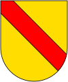
coat of arms
The coat of arms of the former municipality of Jettkofen, which has been in use since July 28, 1927, shows a golden ear of wheat and a silver sickle crossed diagonally in blue.
Culture and sights
Buildings
In Jettkofen there is a " field cross " (Am Gunzenhauser Weg, parcel 335), the " Chapel of St. Wolfgang and Katharina " (Einharter Strasse, parcel 23), the " former mill " (Mühlgasse 6; 1832) , consisting of a " fountain from fountain stock and shell "(Ostracher Strasse, between No. 9 and 13), a" wayside cross "(Tafertsweiler Strasse, parcel 147; 1882) as well as the" memorial column to the battle of Ostrach "(parcel 697) under monument protection .
Chapel of St. Wolfgang and Katharina
The date of the construction of the first chapel in Jettkofen is not known, since the 13th century Jettkofen had belonged to the parish of Ostrach as a church branch. A chapel was mentioned for the first time in 1568, and in 1579 a reconstruction or a new building was consecrated by the Constance Auxiliary Bishop Balthasar in honor of Our Lady , Saint Wolfgang and Saint Catherine . In 1775 the chapel got a new bell, between 1895 and 1985 the building was renovated five times.
Tri-border region
At the foot of the Klausenberg ( 603.4 m above sea level ), north of Jettkofen ( coordinates ), there was one of four three-country corners in the Ostrach district in 1806 , the suburbs of which were in Baden , Hohenzollern and Württemberg , where the three countries combined common boundary point encountered. This point is marked by a border post with a sign from the Ostrach Border Stone Museum and the three coats of arms of the former countries. The other three-country corners are at Magenbuch , Laubbach and Wangen .
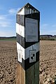
Border post
to bathe
Hohenzollern

Württemberg


Economy and Infrastructure
traffic
Citizen bus

The Ostracher Citizens' Bus complements local public transport and improves, among other things, the mobility of people with disabilities. The bus runs three days a week according to a fixed schedule between the center of Ostrach and Jettkofen, Wagen, Bernweiler, Einhart, Levertsweiler, Lausheim and Magenbuch.
The citizen bus is financed by the municipality of Ostrach and operated by the citizen bus association as well as volunteer drivers and helpers.
Others
Ostrach gauge "Jettkofen / Ostrach"
To the south, on Repperweiler Strasse over the Ostrach , at river kilometer 16.0 is the Jettkofen / Ostrach gauge of the Baden-Württemberg flood forecast center and the Baden-Württemberg State Agency for the Environment, Measurements and Nature Conservation (LUBW); The operator is the Tübingen regional council .
literature
- Walter Kempe: From the history of Jettkofen . In: Hohenzollerischer Geschichtsverein (Ed.): Hohenzollerische Heimat, 40th year, No. 2 / June 1990 , pp. 24–31.
Web links
Individual evidence
- ↑ Jettkofen on the website of the municipality of Ostrach , accessed on March 9, 2015
- ↑ Information from the municipality of Ostrach from January 11, 2011.
- ↑ Information from the municipality of Ostrach in the Ostrach Border Stone Museum
- ^ Federal Statistical Office (ed.): Historical municipality directory for the Federal Republic of Germany. Name, border and key number changes in municipalities, counties and administrative districts from May 27, 1970 to December 31, 1982 . W. Kohlhammer, Stuttgart / Mainz 1983, ISBN 3-17-003263-1 , p. 550 .
- ↑ Jettkofen in the description of the Saulgau District Office from 1829, Chapter B34
- ↑ Population of the municipality of Ostrach (as of July 31, 2014)
- ↑ Landesdenkmalamt Baden-Württemberg, "Directory of immovable architectural and cultural monuments and objects to be examined" (in Ostrach); As of June 28, 2011
- ↑ Information board of the Ostrach boundary stone museum on the surveying trail
- ↑ Flyer of the municipality of Ostrach: "CITIZEN BUS CONNECTS - CITIZENS DRIVE CITIZENS", November 2014
Locations: Burgweiler | Jettkofen | Kalkreute-Spöck | Laubbach | Stomach book Lausheim | Tafertsweiler | Cheeks | Far hard
Sub-locations: Bachhaupten | Bernweiler | Flugglers | Egg mill | Einhart | Eschendorf | Gunzenhausen | Habsthal | Rooster Nest | Kalkreute | Laubbach | Lausheim | Levertsweiler | Stomach book | Mettenbuch | Oberochsenbach | Oberweiler | Ochsenbach | Spöck | Tafertsweiler | Ulzhausen | Unterweiler | Waldbeuren | Wirnsweiler | Zoznegg
Hamlet: Dichtenhausen | Freudenberg | Rothenbuehl