
Stomach book Lausheim
|
Stomach book Lausheim
municipality Ostrach
Coordinates: 47 ° 57 ′ 48 ″ N , 9 ° 18 ′ 53 ″ E
|
|
|---|---|
| Area : | 1.65 km² |
| Residents : | 262 (Jul 31, 2014) |
| Population density : | 159 inhabitants / km² |
| Incorporation : | April 1, 1972 |
| Postal code : | 88356 |
| Area code : | 07585 |
Magenbuch-Lausheim is one of eight localities in the Baden-Württemberg community of Ostrach in the Sigmaringen district in Germany .
geography

Magenbuch-Lausheim is about five kilometers northwest of the main town of Ostrach. Neighboring towns are Levertsweiler , Bernweiler , Einhart , Wangen , Jettkofen , Ostrach , Kalkreute , Pfullendorf and Mottschieß .
Expansion of the area
The total area of the Magenbuch-Lausheim district covers around 1651 hectares (as of July 31, 2014). The local area is drained via the Störenbach, which flows through the Lausheimer Weiher, and the Reichenbach, which later flows into it, eastwards to the Ostrach (Danube) .
structure
The village of Magenbuch-Lausheim consists of the sub-villages Lausheim and Magenbuch .
Protected areas
North of Lausheim, on the edge of the Weithart , lies the Lausheimer Weiher, about 13.5 hectares in size . The family-owned pond is used for fishing and swimming. Since 2014 there have been problems with beavers , which cross the entire area with ditches and dams.
history

Lausheim
The place was probably first mentioned in 1266 as "Luzhaim". Since the end of the 13th century Lausheim belonged to the Salem Imperial Abbey .
There are three interpretations of the origin of the place name:
- Lusses were community shares that were originally distributed to fellow villagers after the lot.
- A Lausgütlein is the smallest fraction of a divided farm.
- Laus , Middle High German Lüs , Lüz or Lüze can mean something like "hiding place" or "hiding place" for game or hunter, but also "ambush"
Over the centuries, the spellings Luzhain (1259), Luzhaim (1266), Lüzhain (1274), Lushain (1324), Lusshain (1399), Luhshain (1494), Lushaym (1514), Laußen (1593 and 1700), Lausheimb (1734) and Lausheim used to this day .
Stomach book
In 1216 Maginbuoch or Magenboch was first mentioned in a document. Since 1324 the county of Sigmaringen exercised high jurisdiction. The local rule and jurisdiction lay with the Imperial Abbey of Salem until 1803 . Then the village came to the House of Thurn and Taxis , in 1806 to the Principality of Hohenzollern-Sigmaringen , with this in 1850 to Prussia . Until 1862, Magenbuch belonged to the Hohenzollern Oberamt Ostrach and was incorporated with it into the Oberamt Sigmaringen , which opened up in the Sigmaringen district in 1925 .
Stomach book Lausheim
In the course of the regional reform in Baden-Württemberg , the municipality of Magenbuch and Lausheim were incorporated into Ostrach on April 1, 1972.
Population development
In 2012 256 inhabitants were counted, today 262 people live in the village (as of July 31, 2014).
politics
Mayor
The mayor of Magenbuch-Lausheim is Hubert Frank (as of March 2015).
coat of arms

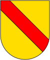
The coat of arms of the former municipality of Magenbuch shows a growing red ram in a split shield above in silver, and below a double-row red and silver slanting bar in black.
Culture and sights
Buildings
Lausheim The Catholic branch chapel Sankt Rupert in Lausheim is a small, Romanesque building with a semicircular apse from the 12th century. The windows were enlarged in the 18th century. The furnishings include an altar from around 1700 and some sculptures from the 14th to 18th centuries, including a painting of Saint Ida of Toggenburg from 1797. Patronage : September 24th
Stomach book
- The Catholic parish church of St. Pankratius in Magenbuch was mentioned in 1263 and rebuilt in 1725 by the local builder Lukas Schindler . Today it appears as a hall with a choir that has just closed. Altarmensa and tabernacle were built around 1500, the structure with paintings in the 17th century. The furnishings also include some sculptures from the 16th to 18th centuries. In the rectory there are two paintings depicting holy bishops from the school of Bartholomäus Zeitblom . Patronage: May 12th
- There is a small monument on the forest path near the forest hut built in 1975.
Tri-border region
To the east of Magenbuch there was one of four three-country corners in the Ostrach district in 1806 , the suburbs of which were in Baden , Hohenzollern and Württemberg , at which the three countries met a common border point. This point is marked by a border post with a sign from the Ostrach Border Stone Museum and the three coats of arms of the former countries. The other three-country corners are at Jettkofen , Laubbach and Wangen .

Border post
to bathe

Hohenzollern

Württemberg


Citizen bus

The Ostracher Citizens' Bus complements local public transport and improves, among other things, the mobility of people with disabilities. The bus runs three days a week according to a fixed schedule between the center of Ostrach and Jettkofen, Wagen, Bernweiler, Einhart, Levertsweiler, Lausheim and Magenbuch.
The citizen bus is financed by the municipality of Ostrach and operated by the citizen bus association as well as volunteer drivers and helpers.
literature
- Historical round stomach book (ed.): Festschrift 800 years stomach book - 750 years Lausheim , 76 pages, June 2016.
Lausheim
- Walter Kempe and Hermann Frank: From the history of Lausheim, part 1. In: Association for history, culture and regional studies Hohenzollern (ed.): Hohenzollerische Heimat. Volume 45, No. 3 / September 1995. pp. 42-45.
Stomach book
- Friedrich Eisele: The gentlemen from Magenbuch. In: Hohenzollerische Jahreshefte 2. 1935, pp. 130–162.
- Josef Strobel: The gentlemen from Magenbuch. In: Association for History, Culture and Regional Studies Hohenzollern (Ed.): Hohenzollerische Heimat, 2nd year, No. 4 / October 1952. (PDF) p. 59 f.
- Josef Strobel: The gentlemen from Magenbuch (continuation and conclusion) . In: Association for History, Culture and Regional Studies Hohenzollern (Ed.): Hohenzollerische Heimat, 3rd year, No. 1 / January 1953. (PDF) p. 12 f.
Web links
Individual evidence
- ↑ Magenbuch-Lausheim on the website of the municipality of Ostrach , accessed on March 9, 2015
- ↑ Top25 Viewer [Top. Map 1: 100000 Baden-Württemberg]
- ↑ Information from the municipality of Ostrach from July 31, 2014.
- ^ Südkurier online: Lausheimer Weiher: From bathing paradise to beaver paradise. , accessed March 9, 2015.
- ↑ Information from the community of Ostrach for Lausheim and Magenbuch in the Ostrach Border Stone Museum
- ^ Federal Statistical Office (ed.): Historical municipality directory for the Federal Republic of Germany. Name, border and key number changes in municipalities, counties and administrative districts from May 27, 1970 to December 31, 1982 . W. Kohlhammer, Stuttgart / Mainz 1983, ISBN 3-17-003263-1 , p. 533 .
- ↑ a b Georg Dehio (Ed.): Handbook of German Art Monuments . Baden-Württemberg I: The administrative districts of Stuttgart and Karlsruhe . Deutscher Kunstverlag, Munich 1993, ISBN 3-422-03024-7 , Magenbuch, p. 430 (first edition: 1966, new edition autumn 2011).
- ↑ Magenbuch in private location database Suehnekreuz.de
- ↑ Information board of the Ostrach boundary stone museum on the surveying trail
- ↑ Flyer of the municipality of Ostrach: CITIZEN BUS CONNECTS - CITIZENS DRIVE CITIZENS. November 2014.
Locations: Burgweiler | Jettkofen | Kalkreute-Spöck | Laubbach | Stomach book Lausheim | Tafertsweiler | Cheeks | Far hard
Sub-locations: Bachhaupten | Bernweiler | Flugglers | Egg mill | Einhart | Eschendorf | Gunzenhausen | Habsthal | Rooster Nest | Kalkreute | Laubbach | Lausheim | Levertsweiler | Stomach book | Mettenbuch | Oberochsenbach | Oberweiler | Ochsenbach | Spöck | Tafertsweiler | Ulzhausen | Unterweiler | Waldbeuren | Wirnsweiler | Zoznegg
Hamlet: Dichtenhausen | Freudenberg | Rothenbuehl