
Scheer
| coat of arms | Germany map | |
|---|---|---|

|
Coordinates: 48 ° 4 ′ N , 9 ° 18 ′ E |
|
| Basic data | ||
| State : | Baden-Württemberg | |
| Administrative region : | Tübingen | |
| County : | Sigmaringen | |
| Height : | 577 m above sea level NHN | |
| Area : | 18.72 km 2 | |
| Residents: | 2490 (December 31, 2018) | |
| Population density : | 133 inhabitants per km 2 | |
| Postal code : | 72516 | |
| Area code : | 07572 | |
| License plate : | SIG | |
| Community key : | 08 4 37 101 | |
| City structure: | 2 districts | |
City administration address : |
Hauptstrasse 1 72516 Scheer |
|
| Website : | ||
| Mayor : | Lothar Fischer | |
| Location of the town of Scheer in the Sigmaringen district | ||
  |
||

Scheer is a town on the Danube in the Sigmaringen district in Baden-Württemberg .
geography
Geographical location

The city is located in the Upper Danube Nature Park . The urban area extends from the last foothills of the Swabian Alb to the beginning of the Swabian Oberland .
Here the Danube, the river formed in the Early Pliocene around 10,000 years ago along the White Jura, looked for a new route through the Ried lowlands . It had previously been buried by the Rhine Glacier and washed out by post-glacial meltwater.
In the "Felsele", a valley between Scheer and Heudorf, the Danube once ran before the Ice Age.
On the last limestone spur on the north side, which the Danube bypasses with a long north loop, Scheer's landmarks rise: the parish church of St. Nikolaus and Scheer Castle. The last mass limestone rocks of the Danube breakthrough valley after the Alb table are located here. The White Jura descends below the town and the valley widens into the soft layers of the Lower Freshwater Molasse .
About 40 percent of the district area is forested.
Neighboring communities
Scheer borders (clockwise) on Mengen , Sigmaringen , Sigmaringendorf and Bingen in the district of Sigmaringen and on Langenenslingen and Altheim in the district of Biberach .
City structure
In addition to the eponymous city center, Scheer also includes the Heudorf district .
| coat of arms | district | Residents | Area (km²) |
|---|---|---|---|
| Scheer (city center) | 2150 | 11.02 | |
| Heudorf | 550 | 7.70 |
history
Prehistory and Antiquity
From the time of 1800 BC. BC to 800 BC The first traces of a settlement date from BC. From this point on, the area was continuously populated. It was then that the eight Celtic burial mounds in the "Lupplet" were built.
The name "Scheer" is derived from the Celtic word "scera" and means rocks that form the last foothills of the Danube breakthrough through the Swabian Alb. This refers to the limestone rocks on which Scheer Castle , the parish church of St. Nikolaus and Bartelstein Castle stand today. Scheer is one of the oldest places in the area. A Celtic primal road from Sigmaringendorf also led south into the Ablachtal and another junction to Blochingen to the Heuneburg . The ford of this Celtic road was about 300 meters upstream from today's Danube bridge. In the community of Scheer, four Hallstatt burial mounds were discovered in 1882 and 1923 and remains of bones, bronze anklets and fibula remains were found.
From about 15 BC The Romans settled in the region until 395 AD . Two Roman roads led across the Scheerer area: from the Ennetach fort on the current country road below the Schlossberg, over the ford of the old Celtic road to today's Laiz to Rottweil , another from Mengen over the ford near Jakobstal, almost dead straight over the Scheerer burial mounds Hitzkofen – Bingen– Feldhausen to Trochtelfingen . During an excavation at four points in the Jakobstal in 1923, the Roman paving was found.
During the construction of the railway in Scheer, graves with bronze jewelry and weapons were found, and these were probably row graves from the Merovingian era.
middle Ages

From 536 to 843 the district of Scheer was in the Franconian Empire in the Alamannischen Westbaar . The Scherragau , Eritgau and Linzgau belonged to this Westbaar . Scheer was probably the main town in the Scherragau. After 843, the time of the East Franconian Empire and the tribal duchy of Swabia followed , which arose at the beginning of the 10th century. In Scheer a "Graf von Ruck" was described (Ruck castles are known from the Lindau and Blaubeuren area). In the 11th and 12th centuries, hill- top castles were increasingly built . The two castles in Scheer (Scheer Castle and Bartelstein Castle), as well as Sigmaringen Castle, are likely to have been built during this period . In 1170, Emperor Friedrich Barbarossa held court days in abundance. In the emperor's entourage, besides Bishop Rudolf, there was also Count Palatine Hugo von Tübingen , who in 1181 became Lord of Scheer, Sigmaringen and Gammertingen .
Count Palatine Hugo von Tübingen died in 1182. His sons, Count Palatine Hugo and Rudolf, initially took over the rule together. After the Montfort family members died out, they also inherited their original home lands Feldkirch , Werdenberg , Sargans and the other possessions in Raetia . When the family was divided, Rudolf received his father's inheritance and became the founder of the Tübingen line. Hugo assumed the Bregenz and Montfort inheritance. The area around Scheer, Sigmaringen and Gammertingen remained joint property. From then on Hugo called himself Count Hugo I von Montfort . He was accompanied to the court day in Ulm in 1218 by a ministerial who called himself Ortolf von Bartelstein . This was the first time a nobleman was named who wrote himself after the castle in Scheer. Count Hugo is also considered to be the builder of the parish church.
Count Hugo I von Montfort died in 1228. His sons divided the rule into a Werdenberger and a Neumontfort line. The founder of the Werdenberg line was Count Hugo II. His brother Count Rudolf I von Montfort, the founder of the Neumontfort line, became ruler in the Scheer area and called himself from then on "Herr zu Feldkirch, Bregenz , Tettnang , Sigmaringen and Scheer".
In the years 1241 to 1258 several towns were founded in the Scheer area: Sigmaringen, Saulgau , Meßkirch , Riedlingen , Mengen and Ehingen . It is believed that Scheer also received Freiburg city rights during this period . At the latest at the end of the 13th century - the castle was already standing on the rock spur - Scheer was elevated to the status of town by the Habsburgs.

In 1260, after the death of Count Rudolf I of Montfort, his domain was redistributed. Count Rudolf II received the rule of Feldkirch, Count Ulrich I the rule of Bregenz and Count Hugo III. the rule of Tettnang. After Count Hugo von Montfort acquired the allodial possession of Count Palatine Hugo III in 1267 . and Rudolf III. of the "Scheerer", he called himself from 1267 "Comes de Schera", and from 1287 Count Hugo von Montfort, Herr zu Scheere. He is considered the first reliably verifiable count who sat at the old Scheer Castle, which later became the palace.
Eighteen years later, in 1278, after the reorganization of the Duchy of Swabia by King Rudolf von Habsburg, a dynasty opposition was formed, which proceeded at war against the king. However, as early as 1281, the king restored order, so that the "Upper Swabian land peace" could be proclaimed in autumn. After that, the king used the increasing debt of the nobility to buy declining noble families and their domains and goods. In 1282 the king bought "Tiengowe and Ergowe" (Diengau and Eritgau) and the villages of Hohentengen and Blochingen, as well as Friedberg Castle z. B. for 1280 marks. After the castle "Vriedeberch", the area was named Friedberg from then on .
In 1285 the dynasty rebellion broke out again. In addition to Count Eberhardt von Württemberg, another 15 counts were involved, including Count Ulrich von Bregenz-Sigmaringen. It is not known whether his brother, Count Hugo Scheerer , was involved in the feud in the course of which the Montfort estates were devastated. The following year the king personally led the fight, and in November 1286 an attempt was made to end the war with a peace.
In July 1287 the king reappeared in Swabia and, in addition to the Count of Württemberg , subjugated the Counts of Tübingen, Montfort and Helfenstein, among others. After the armistice of September 6th, King Rudolf von Habsburg certified in Scheer on October 23, 1287 that his chancellor, Archbishop Heinrich II of Mainz , had brought about an atonement between him and Count Eberhard von Württemberg . The king's stay in Scheer suggests that Count Hugo, as a relative of the king, did not take part in the fighting. On November 2, 1287, Count Hugo donated a property in Reppersweiler to the Habsthal monastery. This was his last official act. Then he sold his Scheer rule to the Habsburgs in 1287 . From the records of the Habsburg possession it can be seen that the king with the castle and town Scheer also Gemmingen, the castle Schatzberg near Egelfingen, the mill and the fishing water in Krauchenwies , the yard behind the Martinskirche in Mengen, goods in Hitzkofen and Bingen and bought the Burgstall (Bittelschieß) . Count Hugo now retired to Tettnang.
In 1289 King Rudolf von Habsburg confirmed the citizens of Scheer their Freiburg city rights. On July 15, 1291, King Rudolf von Habsburg died in Speyer . From 1295 the whole area was subject to a uniform administration with a Vogt as the highest official and presumably based in Scheer. Since then, the city of Scheer has shown tailor's scissors and a star as a sign of royal jurisdiction .
In 1300 the property around Scheer, which also included Ennetach, was recorded in a “Redditus de Schere” (list of goods) and in 1303 it was incorporated into the Habsburg land register . In 1311 the bailiff of the Habsburgs, Schiltung, who had his headquarters in Scheer, called himself "Voget Schiltunch zu der Schaere and elsewhere". In 1312, the Vogt continued to notarize in Scheer, but from then on called himself Vogt Schiltung von Sigmaringen.
After the king's election in 1314, an imperial war broke out. Count Wilhelm sided with the Habsburgs. Duke Leopold of Austria, who stayed in abundance in 1314, pledged the Scheer rule to him for 400 silver marks. In 1342 there was a severe earthquake in the entire Danube valley, which repeated itself several times in 14 days. In that year the plague also spread. An infirmary (Siechensteigle) was built on the mountain to Heudorf. In 1343 the loyal Count and the town of Scheer came into a threatening situation when Eberhard der Greiner defeated Count Konrad von Berg, who was supported by the Austrians, below the Hipfelsberg and, after he had withdrawn to Mengen, stormed and dragged the town.

Count Wilhelm died in 1350. His four sons initially shared the inheritance. After the death of Hugo and Ulrich it was divided in 1354. Count Heinrich von Montfort got the castle and rule Rothenfels, castle, town and rule Tettnang, the castles Argen , Liebenau and Niedersummerau , the bailiwick of the Langnau monastery , the castle and town Scheer, the Diengau, the church orders to Friedberg, Hohentengen and Herbertingen, half of the tax to quantitative, the castle Landau and Ertingen.
In 1405 Count Heinrich von Montfort handed over the town and the Scheer castle to his sons Count Rudolf and Count Wilhelm von Montfort. In 1408, Count Rudolf advanced against the Appenzeller who were feuding with the Bregenz line of the House of Montfort and threatened to attack all of Swabia. When Count Rudolf intervened, the Appenzeller withdrew. On June 15, 1408, his father, Heinrich von Montfort, died. The two sons initially had King Ruprecht confirm their imperial pledges and shared the inheritance. Count Rudolf von Montfort received the Scheer and Diengau pledges. His brother received the other areas.
Just two years later, because of his high debts, Count Rudolf was forced to pledge the county of Friedberg, Burg and Stadt Scheer and the Diengau (Göge) to the knight Wolf von Zillenhard by 1414. The rule of the castle and town of Scheer was still pledged to Heinrich von Reischach . In 1412 Count Rudolf was appointed bailiff of Upper Swabia by Emperor Sigismund . However, in 1414 the Austrians withdrew this bailiff from him after he had pledged the castle and town of Scheer again to the knight Heinrich von Reischach, who was already in power. 1415 was Steward Johann von Waldenburg appointed Governor of Upper Swabia.
Count Rudolf von Montfort died in 1425. Since he was probably single and without descendants, the property fell to his brother, Count Wilhelm von Montfort. In 1433 Kunigunde, the daughter of Count Wilhelm von Montfort, married Eberhard von Waldburg , who had owned Munderkingen, Schongau, Nussplingen, the fortress Kallenberg, Bussen and Wolfegg since 1429. Instead of a dowry, his father-in-law gave him the right to redeem the Grafschaft Scheer with all accessories from the Knights of Reischach. It is not known exactly when he released the deposit from the Reischachs.
1446 was Duke Albrecht VI. from the House of Habsburg regent of the foreland and was also awarded the part of Swabia. He canceled his pledges from Eberhard von Waldburg, especially the Friedberg-Scheer county, although Eberhard had been on Austria's side in the war against the Swiss. Duke Albrecht commissioned Berthold von Stein, the local lords of Uttenweiler , to pay the deposit to Truchsess Eberhard and to hold the pledge. Truchsess Eberhard refused to hand over the pledge because it had been granted to him for life. In April 1447, the impartial Margrave of Baden in Riedlingen was allowed to decide on the dispute. This decided against the Truchsess.
From 1447 to 1452, the von Stein knights ruled the castle and the town of Scheer. In 1450, Duke Sigmund took over the government in the Austrian foothills. Truchsess Eberhard secured him the pledges of the five Danube cities and the fixed buses .
In 1452, the Duke pledged his county and glory of Friedberg to the chief executive Eberhard von Waldburg, including the castle and the town of Scheer, the castle, castle stables, town grounds, courts, compulsory bans, fishing rights, taxes, plus the bailiwick of the villages of Tissen (Groß - and Kleintissen). This pledge agreement was converted into a purchase agreement a few days later. In the same year, the Truchsess received the city of Mengen as a pledge. The property in Scheer was recorded in a land register in 1452. Scheer was now the residential town and administrative seat of the Eberhard line of Truchsessen von Waldburg. In 1454, Duke Sigmund assured Eberhard, Jakob and Georg von Waldburg that neither he nor his heirs would remove the five Danube cities, including the buses , Winterstetten and Ellwangen, from them. Only if all three were to die without male heirs would these cities and lordships revert to the House of Austria.
1460 Truchsess Eberhard entered the service of Duke Sigmund and took part in the war against the Confederates as a member of the knight society " St. Georgenschild " . In 1463, the Sonnenberg line of the Waldburg family , i.e. that of the Eberhard tribe, was elevated to the rank of imperial count by the emperor.
In 1479 Eberhard I. Graf zu Sonnenberg and Truchsess zu Waldburg died. He was buried in Scheer. In 1480 the inheritance was divided among three sons after Count Otto von Sonnenberg (Bishop of Constance) renounced the inheritance. Count Andreas von Sonnenberg received the county Friedberg and the rule Scheer including the Vogtei Sießen, Bachhaupten, Tavertsweiler, Osterdorf and Gunzenhausen. In 1485 he had the early medieval castle torn down and the castle, which is still in good condition, built. In 1486 he entered the service of the Roman-German King Maximilian I , who waged war against France in the Netherlands . Soon he was one of its most distinguished councilors and excellent military leaders.
Early modern age
In July 1505, Count Andreas stayed at the Reichstag in Cologne as a follower of Duke Ulrich von Württemberg . Then he returned to Scheer. In the meantime the new construction of the castle was completed, so that on October 8th the Bishop of Constance could consecrate the castle chapel and the also completed parish church of St. Nicholas. From 1511, the head sessor Wilhelm the Elder ruled Scheer. Under his rule, a "Leibaigenleuthbuch" was created for the first time, in which all serfs were listed and which was continuously supplemented. In 1557, truchess Wilhelm the Younger took over the reign of Scheer.
Wilhelm the Elder Younger died in 1566 after only nine years of reign. As a result, the city received a guardianship government until 1578 Truchsess Christoph Karl took control of Scheer. In 1593, head coach Christoph took over the fortunes of the city. He was followed in 1612 by Truchsess Wilhelm Heinrich, who administered the areas in and around Scheer for 40 years.
In 1652 the Counts Christoph and Hans Ernst von Waldburg ruled, followed in 1658 by the Truchsessen Christoph Karl and Otto, who in turn were replaced in 1663 by the Truchsessen Karl and Maximilian Wunibald. In 1671 there was tension between Christoph Karl and the town hall because of serfdom . An imperial commission of inquiry tried to mediate, but Christoph Karl did not give in. Therefore, in 1672 Truchsess Maximilian took over the guardianship and rule. However, the tensions persisted. The Scheerer citizens refused to pay homage to the new rule. They refused to do labor and did not pay the taxes due to Martini . Thereupon they were ordered to pay homage by the Reich Chamber of Commerce. Also in 1673 the Scheerer citizens stuck to their point of view, whereupon Emperor Leopold ordered the area to be sequestrated . In 1687, Emperor Leopold I, in his capacity as Archduke of Austria , let the Oberamt Scheer take possession of the empire, whereupon Scheer was given the title "Imperial-Archduke" and paid homage to the authorities again.
In 1696, the returned Count Maximilian Wunibald was locked up by the Scheerer citizens in his castle on the left bank of the Danube (Bartelstein Castle). They forced him to make a comparison. This was possible because the upper lordship was under administration from 1696 to 1717 . From 1717 head sessor Josef Wilhelm ruled the Oberamt Scheer , followed in 1756 by Count Leopold August. After his death in 1764, the Scheer county was taken over by the heirs.
In 1785 the County of Scheer came under the sovereignty of the Princes of Thurn and Taxis . In 1798 French soldiers were quartered in Scheer, and there were looting and troop marches. On January 28, 1799, the Danube bridge and a house were torn away during flooding. Another house was half swept away.

Württemberg time
In 1806 Scheer came to the Kingdom of Württemberg on the basis of the Rhine Confederation Act and was assigned to the Oberamt Saulgau . In the same year a royal border customs guard was hired. The city thereby lost its main source of income. From 1825 to 1827 the city fortifications, including the Donautor and the Mengening Gate, were largely demolished. In this context, the city council tried to “warmly demolish” a house at Menger Tor, but it failed. It only earned the Scheerer citizens the nickname "Mußbrenner". The “must burner” has been a well-known Scheer'mer carnival figure ever since. In addition, this deliberate arson also cost the town councilor Hummler the position.
In 1828 the priest and poet Eduard Mörike stayed in Scheer for the first time and visited his brother, the bailiff Karl Mörike.
In 1838 the construction of the new town hall began. The old, dilapidated town hall was sold for demolition for 905 guilders . The new town hall building was billed for a total of 10,500 guilders in 1840. The council servant's apartment and a detention facility were on the first floor, the offices on the first floor and the town council's apartment on the second floor. In 1844 the council decided not to accept any new citizens in Scheer and not to let any local residents marry, since “excessive marrying” was the main cause of the increasing population and the associated impoverishment.
After the March Revolution of 1848, the armament of the people was prescribed by law. Everyone responsible had to procure the weapons himself. However, on July 23, the council and the citizens' committee decided that “all fittings” should be paid for by the city treasury and remain in the possession of the city. In 1849 it was decided to set up a vigilante group .
Since the course of the Danube below the city had shifted by more than 100 meters since 1820, creating a large island, the council decided in 1851 to straighten the river in order to reduce the risk of flooding. The Danube correction was completed in 1851.
In 1866 the railway construction office was quartered in Scheer. At the same time Scheer received a telegraph station and a post office . In November 1870, the Mengen – Scheer section of the Ulm – Sigmaringen railway line was ceremoniously opened, with the result that it was integrated into the rail network of the Württemberg State Railways . Because of the Franco-Prussian War , construction was not continued at first, so Scheer initially remained the terminus of the Ulm - Sigmaringen line. In 1871 construction was continued in the direction of Sigmaringen. On July 26, 1873, the Scheer - Sigmaringen railway line was completed. In 1880 the wooden bridge over the Danube was demolished and replaced by a stone bridge. In 1881 the bridge was inaugurated after the bridge saint had been re-erected.
In January 1899, a severe storm caused great damage to buildings and the forest. The heavy rains that followed caused the Danube to swell sharply on the night of January 14th to 15th. The water rose to four meters above the usual level and completely flooded the city.
From February 1, 1903, the street lighting in Scheer was switched to electricity.
In 1908 Stadtschultheiß Deschler retired after 42 years of service. For his great services he was made an honorary citizen . Karl Josef Rist (born February 2, 1883 in Altshausen) was his successor in the Stadtschultheißenamt. On November 29, 1910, a major fire in the northeast corner of the city destroyed houses on the Graben and the "Hohbühl". With the "Hohbühl" and the aforementioned group of houses that was built on the city wall, a characteristic part of Scheer was lost. The "Hohbühl" was a Gothic building that was built between 1470 and 1480.
On July 31, 1914, at the beginning of the First World War, a military railway guard moved into the Scheer station building. In the course of the First World War, 264 men moved from Scheer. 44 fell, seven were taken prisoner.
On December 24th and 25th, 1918, the city was three feet under water. The water level rose from 0.73 m to 3.75 m. In the 1932 presidential election Scheer counted 804 voters. Of the 659 votes cast, all of which were valid, received: Paul von Hindenburg 550, Adolf Hitler 71, Ernst Thälmann 28, Theodor Duesterberg 10.
Nazi era
On March 21, 1933, the first National Socialist rally took place, which ended with a “bonfire” on the Schachen. On March 31, the municipal council was dissolved by the provisional Reich law for the synchronization of the states . The mayor took over the provisional representation. On May 1st, the then so-called “National Labor Day”, the SA appeared in uniform for the first time . At the crossroads to Heudorf an oak was planted, the " Hitler Oak ". At the request of the residents of Friedhofstrasse (Gemminger Strasse), it was renamed Adolf-Hitler-Strasse.
On June 25, 1935, southern Germany was struck by a severe earthquake. The tremor lasted only 4-5 seconds but was very severe. This main shock was followed by several aftershocks. Scheer was the hardest hit place. Almost no building was left without damage. The castle had become uninhabitable. The courtyard was littered with rubble. The statues that had been on the castle gables for 400 years fell down. The church had cracks the width of a finger. The ceiling paintings in the choir were destroyed. The church wall facing the city was torn and partially slipped.
In 1938 Scheer was assigned to the Saulgau district as part of a regional reform in Württemberg during the Nazi era .
On August 26, 1939 there was mobilization and many Scheerer were called up. On September 11th Scheer had to mourn the first casualty: Hermann Zimmerer, died at the age of 23 in the battle of Osik.
In 1941 the first French prisoners of war were housed in the castle. They were taken to work in the paper mill every day. In 1942 the captured French were assigned to Scheer and replaced by " Eastern workers ", mostly former Russian soldiers who had defected. As a result, they received better treatment than the prisoners of war. The year 1945 began with a very cold January. A soldier was shot dead on the Mengener Strasse for not obeying orders . On April 21st, the bridge was blown up by the SS . The railway bridge followed on April 28th. Around 2 p.m. French tanks drove to Scheer from the direction of Mengen and occupied the city without a fight. A girl ran towards them with a white flag. The city was "released" to the troops who had moved in for three days. The French commandant tolerated the soldiers - Alsatians and mostly Moroccans - looting shops and private homes and raping them numerous times.
As a result of the Second World War, the city of Scheer lamented a total of 55 fallen and 31 missing soldiers, and 237 returned from the war.
post war period
After the end of the war Scheer belonged to the French zone of occupation .
In 1946 the mayor Karl Josef Rist retired after 38 years. Until September 15 his deputy Anton Eisele assumed the position was until the French occupation force i the police sergeant. R. Hans Heiß was appointed honorary mayor. Scheer's last night watchman, Xaver Will, who had held this post since 1913, retired. After that, the position was no longer filled. On July 23, 1946, the new construction of the Danube bridge began. On October 13, 1946, the first election (district election) took place after the war. 427 out of 767 eligible voters took part. The CDU received 7,003 votes, the SPD 748, KPD 179 and DVP 61.
On May 18, 1947, the state of Württemberg-Hohenzollern was officially founded, to which the Saulgau district also belonged to the town of Scheer, after a forerunner of this state with a provisional state secretariat under Carlo Schmid had been established on October 16, 1945 by the occupying power was.
In 1947 the occupying power had still quartered 32 families in Scheer. Houses had previously been confiscated for them, the residents of which had to move out immediately and leave their furnishings behind. In January, 70 evacuees and displaced persons were registered in Scheer . The housing shortage made compulsory management of the apartments necessary. The kindergarten had over 100 children. On October 1st, 32 Scheerer men were forced to build bridges in the presence of the District Administrator.
The Danube Bridge was inaugurated on March 4, 1948. Present were representatives of the French military government and civil German officials from the state and local authorities. On July 7th, the construction of the new railway bridge began.
Ernst Müller took first place in the " Grand Prix of Darmstadt " with his motorcycle, a 250 cm³ DKW machine, and received a special prize for his outstanding motorsport performance.
On January 4, 1949, Georg Eberle, born on December 15, 1900 in Bockighofen , was appointed to the mayor's office. On April 14, 1949, the railway bridge was opened to traffic without any special ceremony. During the year Scheer was assigned 200 displaced persons.
Scheer has been part of the new federal state of Baden-Württemberg since April 25, 1952 .
In 1952 and 1953, a 130 m deep shaft was drilled through the Jurassic rock for the water supply . In the spring of 1953 they found what they were looking for. The new water supply created as a result was put into operation on January 20, 1954. The correction of the Danube in 1960 required a border change with Sigmaringendorf.
On January 3, 1967, Rolf Keller, born in Dornstetten in 1940 , was introduced to his office as mayor. In May 1967 the writer Erich Schneider-Leyer bought the castle and the park from the Prince of Thurn and Taxis for 38,000 DM . The 13 families who lived there were given notice in May 1968.
In 1968 the city coat of arms was changed to its current form. From May the rail freight traffic was relocated to the Mengen station. Erich Schneider-Leyer brought the first Dogo Argentino to Europe at Scheer Castle. He was the first to breed Dogo Argentinos in Europe and Germany.
In 1973 the district reform came into force. Scheer came from the dissolved Saulgau district to the Sigmaringen district. In the course of the community reform , the community of Heudorf came to Scheer on January 1, 1974. In the mayoral election, Mayor Keller was re-elected. In 1975, the Fasnets-Konde presented the Konde fountain they had built on Hindenburgplatz to the public.
On February 7, 1980, the city had the largest Danube flood since the floods of 1919. The water level at the Danube bridge was 2.70 m. The Danube flooded the entire lower town. In 1981 the sewage treatment plant was put into operation. Mayor Keller resigned and took up the post of mayor in Münsingen . His deputy, Wunibald Knor, continued the official business until Gerald Schikorr , who was elected on December 20 and was born in Tuttlingen in 1951 , was appointed mayor on February 1, 1982 by District Administrator Binder.
On May 28, 1983, the last scheduled train stopped in Scheer. After that, the station was closed. In 1999, Mayor Gerald Schikorr was elected Mayor of Blaustein near Ulm. On December 31, he resigned his post after 18 years. His deputy Friedrich Eisele was in charge of official business until a new one was appointed. On March 19, 2000, Jürgen Wild from Albstadt-Ebingen was elected the new mayor of Scheer and Heudorf.
After 16 years in office, Jürgen Wild was no longer a candidate. Lothar Fischer from Scheer, who took office on May 2, 2016, was elected as his successor.
Population development
| year | 1823 | 1858 | 1880 | 1905 | 1925 | 1933 | 1954 | 1961 | 1969 | 1979 | 1985 | 1995 | 2000 | 2005 | 2010 | 2015 |
| Residents | 860 | 1000 | 1097 | 1121 | 1200 | 1251 | 1585 | 1666 | 1780 | 2250 | 2315 | 2697 | 2668 | 2627 | 2553 | 2523 |
Incorporations

The community Heudorf bei Mengen was incorporated into Scheer on January 1st, 1974. The name of the place is probably derived from the topographical location. Heudorf lies at an altitude of 588 m and has about 550 inhabitants.
Heudorf was first mentioned in a document in 1231. The first traces of settlement come from the Celtic era.
politics
Municipal council
The local elections on May 26, 2019 resulted in a voter turnout of 60.0% (2014: 50.1%) to the election of 15 local councils belonging to individual voter communities. Four of the 15 councilors are women. An additional member is the mayor, who is the chairman of the committee.
mayor
On February 14, 2016, Lothar Fischer was elected with 50.32 percent of the valid votes with seven opposing candidates in the first ballot.
- 1908–1946: Karl Josef Rist
- 1946–1949: Hans Heiss
- 1949–1967: Georg Eberle
- 1967–1981: Rolf Keller
- 1981–1999: Gerald Schikorr
- 2000–2016: Jürgen Wild (CDU)
- since 2016: Lothar Fischer
coat of arms
|
|
Blazon : "In red under a silver fish (huchen) a silver tailor's scissors with the open blades turned upwards, underneath a six-pointed gold star." |
| Justification of the coat of arms: The scissors stand in this talking coat of arms for the city name. The fish symbolizes the location on the Danau and the star is interpreted as a Habsburg emblem. |
Culture and sights
Scheer is a stop on the Mörike Path, as the poet Eduard Mörike stayed here several times for a long time and also wrote some of his poems here. In addition, the city is on the Upper Swabian Baroque Road and the Danube Cycle Path , one of the most beautiful long-distance cycle routes. An estimated 10,000 cyclists cross the city along the Danube every year. Furthermore, the city is part of the "Upper Swabian Danube" tourist region.
Buildings
- The late Gothic Scheer Castle was built between 1485 and 1496 by Andreas von Sonnenberg from Waldburg. It saw changes in the style of the Renaissance and has not been significantly changed since then. The three-gabled castle is privately owned, inhabited and not accessible.
- The Bartel flintlock was used in place of the Thirty Years War built ruined castle. It has its current form from 1908. It is not accessible, is inhabited and houses holiday apartments.
- The Nikolauskirche , parish church of Scheer, was built in the 14th century as a three-aisled basilica and changed to Baroque style in the middle of the 18th century. In addition to rich stucco decorations and paintings, the sculptures by Joseph Anton Feuchtmayer are part of the furnishings.
- Loretto Chapel
- St. Leonhards Chapel
- St. Anne's Chapel
- St. Oswaldi Chapel
- Condenser well
- The former fruit box at Sigmaringer Straße 13 is a protected cultural monument.
- On the Danube Cycle Path between Sigmaringendorf and Scheer, a new well was built in May 2010 in the “Mengener Au” area. The groundwater was collected via a wooden channel into a wooden trough, both made of beech wood, and from there via the cycle path.
- On the district road 8265, the local connection route from Scheer to Laucherthal, there is a stone cross with paws on the left of the road.
Parks
- Scheer Castle Park
- gallery

Bartelstein Castle above the left bank of the Danube

The limestone caves under Bartelstein Castle
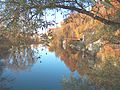
The autumnal Danube above Scheer

The Scheer Palace Park with its ancient trees
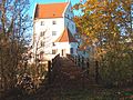
The south side of Scheer Castle seen from the castle park

The northwest view of Scheer
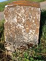
Old boundary stone on the former border with the Kingdom of Prussia

Old boundary stone on the former Württemberg / Prussian border in the Scheer district


Regular events

- May Festival
- May procession
- Corpus Christi procession
- Bridal
- Fasnets buried
- Sound bath festival (annually, beginning of August)
Culinary specialties
Gröst ’s - a food that is mainly consumed on Carnival Monday after the wedding . It consists mainly of offal ( liver , kidney , heart , tripe ).
Economy and Infrastructure
traffic
-_Bahn%C3%BCbergang-_Richtung_Ulm_6.11.2010.jpg)
_aus_7.11.2010.jpg)
Scheer is on the Ulm – Sigmaringen railway line. However, there are currently no trains stopping in the city. The city's former train station was converted into a hotel after its abandonment.
The city is also on the federal highway 32 between Herbertingen and Sigmaringen.
The public transport is in the Verkehrsverbund Neckar-Alb-Donau integrated (NALDO).
Scheer is connected to cities such as Vienna and Bratislava as well as the Atlantic and the Black Sea via the Danube Cycle Route and the European long-distance EuroVelo 6 cycle route .
Established businesses
- Seal factories
- Last production
- Plastics processing
- Facade systems
- Frozen ready meals
Public facilities
- Retirement and nursing home St. Wunibald
- OWB dormitory for people with disabilities
- Kinderhaus "Familienzentrum Sonnenschein" in Scheer, Kindergarten Heudorf
- Multipurpose halls in Scheer and Heudorf
education

The local elementary school is called the Countess Monika School . It is named after the founder of the local poor and school fund, Countess Anna Maria Monika von Waldburg-Trauchburg zu Friedberg and Scheer. The school is located on the Kirchberg below the St. Nikolaus church.
The primary school in the district of Heudorf was closed at the beginning of the 21st century due to falling student numbers. The Heudorf children have been attending school in Scheer ever since. There is a kindergarten each in Scheer and Heudorf.
Personalities
Honorary citizen
- Karl Deschler (born December 2, 1841 in Geislingen / Steige; † December 14, 1914), 1866–1908 city school in Scheer, in 1908 made an honorary citizen of Scheer.
sons and daughters of the town
- Otto Truchsess von Waldburg-Trauchburg (1514–1573) was a cardinal and bishop of Augsburg
- Franz Heim (1792–1845), chemist and physician
- Editha Pröbstle (* 1948), graphic artist and sculptor
Personalities with connections to the city
- Franz Xaver Clavel (1729–1793), Oberamtmann in Scheer
- Eduard Mörike (1804–1875), poet, stayed from February to May 1828 with his brother Karl, bailiff in Thurn and Taxis' service in Scheer, in order to be clear about his talent as a poet. Several works were created during this time. Mörikestrasse is a reminder of this incident.
- Dietmar Schlee (1938–2002), politician, grew up in Scheer
- Fred Arendt, art and portrait painter
- Ernst Müller , motorcycle racing driver, won the Darmstadt Grand Prix in 1948
- Markolf Hoffmann (* 1975), writer, grew up in Scheer
literature
- Walter Bleicher: Chronicle of the former residence town Scheer / Danube. Geigerdruck, Horb am Neckar 1989, ISBN 3-89264-326-1 .
Individual evidence
- ↑ State Statistical Office Baden-Württemberg - Population by nationality and gender on December 31, 2018 (CSV file) ( help on this ).
- ↑ a b c d e The panorama trail around Scheer . P. 49f. In: Wanderbar ... the most beautiful routes. Experience the Sigmaringen district . Sigmaringen district office, Schönebeck printing company, Meßkirch 2004.
- ↑ a b c To spread the word! Did you know that ... In: Südkurier on August 17th, 2011
- ↑ a b Federal Statistical Office (ed.): Historical municipality register for the Federal Republic of Germany. Name, border and key number changes in municipalities, counties and administrative districts from May 27, 1970 to December 31, 1982 . W. Kohlhammer, Stuttgart / Mainz 1983, ISBN 3-17-003263-1 , p. 549 .
- ↑ State Statistical Office of Baden-Württemberg - Preliminary results of the 2019 municipal council elections: City of Scheer , accessed on October 10, 2019
- ↑ Baden-Württemberg State Archives
- ↑ Tourist routes . In: Swabian Alb! traveling there, of course, the nature place to go . ed. from the Swabian Alb Tourism Association. Bad Urach 2010; P. 10 f.
- ↑ Vera Romeu (from right): Birth: The new region is called Upper Swabian Danube. Sigmaringendorf, Krauchenwies, Mengen, Scheer, Hohentengen and Herbertingen are to merge. In: Schwäbische Zeitung from February 19, 2011.
- ^ Kurt Kugler: Rest Area. A new fountain adorns the Danube Cycle Path . In: Schwäbische Zeitung of May 11, 2010.
- ^ Scheer in the private location database Suehnekreuz.de.
- ↑ Bernhard Losch: The hall stone crosses in Baden-Württemberg . In: Preservation of monuments in Baden-Württemberg, 1st year, issue 4, 1972 . Pp. 28-38.
- ↑ webmaster: EuroVelo 6: explore the European rivers by bike! - EuroVelo. Retrieved April 29, 2017 .
- ^ Official Journal of the City of Scheer. (PDF) Stadt Scheer, October 27, 2017, accessed on December 23, 2017 .
Web links

Bad Saulgau | Beuron | Bingen | Gammertingen | Herbertingen | Herdwangen-Schönach | Hettingen | Hohentengen | Illmensee | Inzigkofen | Krauchenwies | Leibertingen | Quantities | Messkirch | Neufra | Ostrach | Pfullendorf | Sauldorf | Scheer | Schwenningen | Sigmaringen | Sigmaringendorf | Stetten am kalten Markt | Veringenstadt | Forest