
Bärenthal
| coat of arms | Germany map | |
|---|---|---|

|
Coordinates: 48 ° 4 ' N , 8 ° 56' E |
|
| Basic data | ||
| State : | Baden-Württemberg | |
| Administrative region : | Freiburg | |
| County : | Tuttlingen | |
| Local government association: | Danube Heuberg | |
| Height : | 669 m above sea level NHN | |
| Area : | 12.69 km 2 | |
| Residents: | 484 (December 31, 2018) | |
| Population density : | 38 inhabitants per km 2 | |
| Postal code : | 78580 | |
| Area code : | 07466 | |
| License plate : | DOES | |
| Community key : | 08 3 27 004 | |
| LOCODE : | DE B4J | |
| Address of the municipal administration: |
Kirchstrasse 8 78580 Bärenthal |
|
| Website : | ||
| Mayor : | Tobias Keller | |
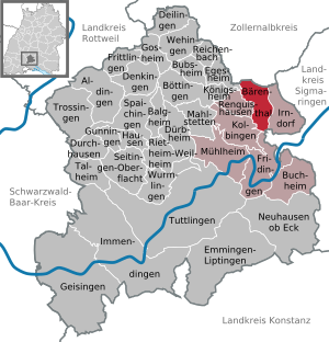
| Location of the municipality of Bärenthal in the Tuttlingen district | ||
  |
||

With fewer than 500 inhabitants, Bärenthal is the smallest municipality in the Tuttlingen district in Baden-Württemberg , Germany .
geography

Geographical location
The state-approved resort town of Bärenthal is located in the Obere Donau Nature Park on the Großer Heuberg at 650 m to 950 m above sea level. NHN . On the boundaries of the municipality of the united Upper and Lower Bära for Bara , in Fridingen on the Danube in the Danube flows, and is within the valley houses.
Although the total area of the municipality of Bärenthal encompasses around 1270 hectares, due to the small number of inhabitants it is one of the smallest independent municipalities in Baden-Württemberg.
Almost 70 percent of the community area is covered by forest.
Neighboring communities
The community borders in the north on Nusplingen in the Zollernalb district , in the east on Irndorf , in the south on Beuron in the district of Sigmaringen and Fridingen an der Donau , in the west on Kolbingen and Renquishausen and in the northwest on Egesheim .
Community structure
The community of Bärenthal includes the village of Bärenthal, the hamlets Ensisheim and Gnadenweiler and the Karlswahl homestead.
history
Already from the time of prehistory and early history, finds were found in the Bärenthal district that indicate human settlement. Two bronze age bracelets were found at the end of the 20th century . After the Celts came the Romans. The Bärenthal was located in the Roman Empire in the protected hinterland of the Alblimes . The finds of Roman coins with the inscription of Emperor Trajan date from this time . The Romans in turn were ousted by the Alamanni . In December 2007, human skeletons were found during development work in the “Eschle” industrial park. Since 2008, these 100 or so graves for men, women and children have been archaeologically excavated (as of September 2010). Together with the three early medieval iron swords discovered during the construction work on Landesstraße 440 in 1967, they allow conclusions to be drawn about a larger Franconian-Alemannic settlement. In addition to the graves, the remains of a stone church (north-east corner) were found in 2009 and the remains of a mortar mill, a pit house and post holes in 2010 , which are evidence of settlement between the 7th and 11th centuries.
The place "Bärenthal" was first mentioned in 1092. Since the 14th century, the Beuron monastery increasingly acquired property in the Bärenthal area. In 1459 Marquard von Werenwag sold Burgstall and the village of Ensisheim to Renhard von Melchingen . Jobst Nikolaus I (Hohenzollern) bought the castle and the village of Ensisheim from Melchior von Tierberg and Heinrich Rieber in 1477 . There was also a prison there. In 1751 the Hohenzollerns sold Ensisheim to the monastery.
In the course of the First Coalition War (1792–1797) the place fell victim to the angry Soldateska of the French Rhine-Moselle Army, commanded by General Moreau and retreating from Bavaria to the Upper Rhine, on October 7, 1796; Eight residents of Bärenthal are said to have been murdered by French soldiers that day, while 21 buildings in the village fell victim to the flames, including the rectory and the manor house of the Beuron monastery along with the associated barns and stables.
In the course of secularization , the village came to the Principality of Hohenzollern-Sigmaringen in 1803 and became Prussian with this in 1849 as part of the Hohenzollern Lands . From 1806, Bärenthal initially belonged to a Hohenzollern Oberamt , the Obervogteiamt Beuron , which became part of the Oberamt Wald in 1830 . The Oberamt Wald also existed from 1850 to 1862 under Prussian rule and was then incorporated into the Oberamt Sigmaringen , from which the Sigmaringen district emerged in 1925 .
After 1945 the former Prussian district of Sigmaringen belonged to the state of Württemberg-Hohenzollern , which was added to the state of Baden-Württemberg in 1952. During the district reform in Baden-Württemberg in 1973 , Bärenthal was assigned to the Tuttlingen district on January 1, 1973 .
politics
Administrative association
The community is a member of the community administration association Donau-Heuberg , based in Fridingen an der Donau .
Municipal council
The municipal council in Bärenthal has eight members. It consists of the voluntary councilors and the mayor as chairman. The mayor is entitled to vote in the municipal council. In the local elections on May 26, 2019, the local council was elected by majority vote. Majority voting takes place if no or only one nomination has been submitted. The applicants with the highest number of votes are then elected. The turnout was 70.1% (2014: 66.8%).
mayor
On July 10, 2011, Tobias Keller was elected honorary mayor of the municipality of Bärenthal with 59.57 percent of the vote, with a turnout of 78.93 percent. His inauguration took place on September 5, 2011. He replaced Roland Ströbele after 31 years in his office, who retired after 51 years in public service.
- until 1980: Karl Franz
- 1980–2011: Roland Ströbele ( CDU )
- since 2011: Tobias Keller
coat of arms
|
|
Blazon : "In a split shield above in gold a striding blue bear, below in blue the golden lowercase letter 'b', the shaft of which ends in a cross." |
| Crest Reason: The on a proposal of the State Archives Sigmaringen in 1947 and granted by the Home Office on May 8, 1957 crest, along with the flag, stands by the bear talking for place names, which, however, from the river Bara is derived. The 'b' with the cross at the end of the shaft is the characteristic coat of arms of the Beuron monastery , which acquired ownership and lordship since the 14th century and in 1751 the lower jurisdiction over the place. The colors are also taken from the monastery coat of arms. |
Banner and flag
 |
Banner: "The banner is blue-yellow striped lengthways with the coat of arms above the middle." |
 |
Hoisted flag: "The flag has blue and yellow stripes with the coat of arms in the middle." |
Environment and Regulation
The resort of Bärenthal is embedded in the landscape of the deep Bäratal. The very large, only one-tenth populated area of the small town is "framed" on all sides by dense mixed forests. The river Bära flows leisurely on the largely natural, wide valley floor of the district - except at high tide.
The district of Bärenthal, which is built on by commercial space and residential buildings, is surrounded by the FFH protection zone, which is 9/10 of the boundary . The protection zone comes close to the built-up areas on all sides. Bärenthal can therefore practically not expand, because only intervening measures are permitted in the protection zone, "which do not significantly affect the habitat types of flora and fauna !"
Culture and sights
- The municipality is affiliated with the "Donaubergland" tourist association.
- The hardly accessible karst phenomenon, the moon milk hole near Bärenthal, was a Stone Age habitat. The peculiarities of the cave are pearl sinter coatings and walls with fresh moon me (white, plastic-soft limescale).
- "Hüttenberg nature reserve". The nature reserve begins on the above-average "warm slope zone" directly above the housing development of Bärenthal with a juniper heather . Sheep will graze on it to keep the various grasslands free of tree vegetation. Between the structurally diverse, near-natural species of beech, several larger pillars of hard mass limestone cliffs protrude, which are characterized by a special combination of “rock-typical plant communities”, some of which are in need of protection.
- In Bärenthal-Ensisheim there is the historic Schlößlemühle (2.1 km north of the main municipality of Bärenthal), whose main mill used to be operated with Europe's largest overshot wooden water wheel (diameter 12 m) and its auxiliary mill, which is driven by a restored undershot water wheel can (now closed).
- From the lime-rich rivulets of numerous karst springs on the slopes of the Bära valley , a lot of lime has been precipitated again and has layered several large areas and formed tufa limestone bars.
- On the western slope of the river valley, the largest, lens-shaped tufa layer of the natural area " Hohe Schwabenalb " has been proven. Here the tuff limestone is extracted and sold in a last part-time quarry.
- To the south of the large, lenticular limestone deposit, there is the natural monument “Tuff Stone Cascades”. A small waterfall flows down into the valley in several stages. The precipitated limestone remains on the cascades as a still wet sediment "limestone tuff".
- In the former large quarry in Bärenthal-Ensisheim, two well-preserved, high tufa walls are still preserved, from which the porosity of the petrified sediment can still be seen very well.
Buildings

The parish church of St. John was built in 1758 in the baroque style. After the baroque high altar was temporarily removed during a church renovation in 1883 and modern fittings were added during a renovation in 1956, the original baroque appearance was restored in a further renovation, which was completed in 1989.
The pilgrimage chapel of Our Lady of Europe on the Gnadenweiler is a sacred building of the 21st century: the foundation stone was laid on November 3, 2006, the sanctuary of Mary was consecrated on June 9, 2007.
religion
Bear valley population is predominantly Roman Catholic denomination . The Catholic parish is part of the Archdiocese of Freiburg via the Sigmaringen-Meßkirch deanery . In 1720 about 40 people had to leave the place because of their conversion to Protestantism and emigrate to Wurmberg in Württemberg. Prince Karl Anton von Hohenzollern-Sigmaringen has hired a Protestant preacher for Protestant church members, and Protestant services have been celebrated in the castle chapel in Sigmaringen since 1840. In 1860, the Evangelical parish of Sigmaringen, responsible for Bärenthal, was established in Hohenzollern. In the Protestant church services in Hohenzollern, the old Prussian form of worship can continue to exist on request. In 1951 the Protestants moved to Tuttlingen. The independent parish of Mühlheim an der Donau was founded by the Upper Church Council on December 6, 1963 , after the Ministry of Culture recognized the new parish as a public corporation in a letter of June 24, 1963. The Protestant residents of the Bärenthal community were assigned to her.
Sports
The municipalities of Bärenthal, Irndorf , Nusplingen and Schwenningen created a joint network of trails for winter sports enthusiasts in 2011 . After the connection of the newly created cross-country ski trail on Gnadenweiler to the Indorfer cross-country ski trail network was created, a large area for cross-country skiing was created through the merger with the existing Nusplinger and Schwenninger trails through the Irndorfer Hardt .
Honorary citizen
- Notker Hiegl , Benedictine, longtime local pastor and clergyman, "European of the year 2007"
- 2011, July 26: Roland Ströbele (* 1943), city treasurer and honorary mayor of the municipality of Bärenthal (1980–2011), mayor of the city of Fridingen (Danube) (1977–1994), member of the state parliament for the constituency of Tuttlingen / Schwarzwald-Baar (1984 –1996) and honorary president of the Euro-Bärentaler (appointed July 2011).
See also
literature
- Notker Hiegl OSB (Ed.): A village celebrates. Memories of the 900 year celebration of the Bärenthal community. Beuron [1993].
Individual evidence
- ↑ State Statistical Office Baden-Württemberg - Population by nationality and gender on December 31, 2018 (CSV file) ( help on this ).
- ^ The state of Baden-Württemberg. Official description by district and municipality. Volume VI: Freiburg administrative region. Kohlhammer, Stuttgart 1982, ISBN 3-17-007174-2 , pp. 646-647.
- ↑ Jutta Klug stairs, Joachim Wahl: An industrial area full of surprises - early medieval cemetery in Bärenthal, Tuttlingen district . In: Archaeological excavations in Baden-Württemberg 2008 . Theiss, Stuttgart 2009, ISBN 978-3-8062-2257-9 , pp. 186-191.
- ↑ Holdings Ho156 T1 No.16 on Landesarchiv-BW.de
- ↑ inventory Ho156 No.17 (b) on Landesarchiv-BW.de
- ↑ Holdings Ho177 T2 No. 9 on Landesarchiv-BW.de
- ↑ Jens Florian Ebert: The horror days of Irndorf and Bärenthal in October 1796 and the retreat of the French Rhine-Moselle army by today's Tuttlingen district , Tuttlinger Heimatblätter NF 77 (2014), pp. 57-98.
- ↑ Preliminary results of the 2019 municipal council elections at the State Statistical Office
- ↑ Kurt Loescher (loe): Municipal council meeting. Inauguration of Tobias Keller. In: Südkurier from August 19, 2011.
- ↑ Yvonne Havenstein (hav): Tobias Keller becomes Bärenthal's new mayor . In: Schwäbische Zeitung. July 10, 2011.
- ↑ Natura 2000: Impairments, conservation and development measures of habitat types and habitats of species for the implementation of the Fauna-Flora-Habitat Directive in Baden-Württemberg, State Institute for Environmental Protection Baden-Württemberg, Karlsruhe, 2002. The technical document is available as a PDF file [1]
- ↑ LGRB profile geotope moon milk hole [2]
- ↑ Profile natural monument, extensive, Baden-Württemberg "Waterfall with lime spring corridor" [rips-dienste.lubw.baden-wuerttemberg.de/rips/ripsservices/apps/naturschutz/schutzgebiete/steckbrief.aspx?id=3279002000080]
- ^ The Beck reform movement from 1712 to 1719 , bärenthal.de, accessed on February 27, 2018.
- ↑ https://waldenser.org/portfolio-item/wurmberg/
- ↑ Archived copy ( memento of the original from October 19, 2014 in the Internet Archive ) Info: The archive link was automatically inserted and not yet checked. Please check the original and archive link according to the instructions and then remove this notice.
- ↑ Michael Hescheler (fxh): Star architect brings Prussian elegance to the city. The town church is 150 years old - the congregation presents the anniversary program . In: Schwäbische Zeitung from December 21, 2011
-
↑ Antonia Lezerkoss: Church: Liturgy of the old Prussian way . Südwest Presse Online , February 3, 2017, accessed on February 18, 2018.
Dagmar Stuhrmann: Church: Exhibition “Evangelical in Hohenzollern” stops in Ebingen . Südwest Presse Online, January 26, 2017, accessed on February 18, 2018.
Hechingen: A farewell full of sadness . Schwarzwälder Bote , February 13, 2013, accessed on February 18, 2018. - ↑ Joint trail created . In: Südkurier. January 5, 2011.
- ↑ Wolf-Dieter Bojus: A very large station. ( Page no longer available , search in web archives ) Info: The link was automatically marked as defective. Please check the link according to the instructions and then remove this notice. In: Wochenblatt. July 28, 2011.
Web links

Aldingen | Balgheim | Bärenthal | Böttingen | Bubsheim | Buchheim | Deilingen | Denkingen | Dürbheim | Durchhausen | Egesheim | Emmingen-Liptingen | Fridingen an der Donau | Frittlingen | Geisingen | Gosheim | Gunningen | Hausen ob Verena | Immendingen | Irndorf | Kolbingen | Koenigsheim | Mahlstetten | Mühlheim an der Donau | Neuhausen ob Eck | Reichenbach am Heuberg | Renquishausen | Rietheim-Weilheim | Seitingen surface | Spaichingen | Talheim | Trossingen | Tuttlingen | Wehingen | Wormlings