
Rietheim-Weilheim
| coat of arms | Germany map | |
|---|---|---|

|
Coordinates: 48 ° 2 ' N , 8 ° 46' E |
|
| Basic data | ||
| State : | Baden-Württemberg | |
| County : | Tuttlingen | |
| Height : | 682 m above sea level NHN | |
| Area : | 11.98 km 2 | |
| Residents: | 2824 (Dec. 31, 2018) | |
| Population density : | 236 inhabitants per km 2 | |
| Postal code : | 78604 | |
| Primaries : | 07424, 07461 | |
| License plate : | DOES | |
| Community key : | 08 3 27 056 | |
| Address of the municipal administration: |
Rathausplatz 3 78604 Rietheim-Weilheim |
|
| Website : | ||
| Mayor : | Jochen Arno | |
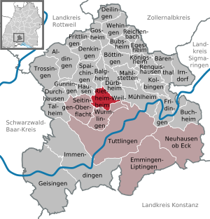
| Location of the municipality of Rietheim-Weilheim in the Tuttlingen district | ||
  |
||

Rietheim-Weilheim is a municipality in the Tuttlingen district in Baden-Württemberg .
geography
Geographical location
Rietheim-Weilheim is on the edge of the Großer Heuberg on the southwest Swabian Alb . The vast majority of the community is located in the Faulenbach valley .
Neighboring communities
The cities of Spaichingen and Balgheim border in the north, Dürbheim in the east and the district town of Tuttlingen via the Nendingen district , Wurmlingen in the south and Seitingen-Oberflacht and Hausen ob Verena in the west . Rietheim-Weilheim only touches the boundaries of Nendingen and Mühlheim at a single point in the Ursental .
Community structure
Rietheim-Weilheim consists of the formerly independent communities of Rietheim and Weilheim.
The former municipality of Rietheim includes the village of Rietheim, the hamlet of Bulzingen, which was incorporated in 1934 and is probably the oldest district, as well as the hamlets of Heuchen, Höfle, Lupbühl, Rußberg and Schmidten and the homestead Kehlen.
The village of Weilheim belongs to the former community of Weilheim. In the area of the former community of Weilheim, the now lost Fürstenstein Castle is located .
Rietheim is about one kilometer away from Weilheim, Rußberg is about 1.5 km as the crow flies from Rietheim and about 2 km as the crow flies from Weilheim. The actual distance to the Rußberg, which is located on the Heuberg-Alb plateau, is, however, much greater, as the difference in altitude of around 300 meters is bridged with serpentines .
history


| The municipality of Rietheim-Weilheim was created on January 1, 1975 through a merger of the two previously independent municipalities of Rietheim and Weilheim in order to avoid incorporation by the city of Tuttlingen . In 1986, Rietheim-Weilheim celebrated their 1200th anniversary together. |
politics
Municipal council
The municipal council consists of 12 people (as of 2014-2019), 7 of them from Rietheim and 5 from Weilheim, plus the mayor as chairman of the council. In the election, the procedure of the false partial location selection is used. There are no political groups.
mayor
Traugott Hauser (CDU, * 1947) was mayor from 1975 to 2007.
Jochen Arno (CDU) has been mayor of Rietheim-Weilheim since 2007; he had previously been mayor of Gunningen since 2000 .
coat of arms
_COA.svg)
|

|
|
|
Coat of arms: left Rietheim,
re. Weilheim before the merger in 1975 |
||
|
|
Blazon : "In a split shield in front in gold (yellow) three right back, five-ended black stag poles one above the other, behind in silver (white) a half red cross at the gap." |
| Justification of the coat of arms: The coat of arms approved on June 29, 1979 refers to the former territorial affiliation of both districts with the Württemberg stag sticks and the half cross of the Hochstift Konstanz . |
Banner and flag
 |
Banner: "The banner is black and yellow striped lengthways with the coat of arms above the middle." |
 |
Hoisted flag: "The flag has black and yellow stripes with the coat of arms in the middle." |
Culture and sights
The municipality is affiliated with the "Donaubergland" tourist association.
Parish Church of St. George
At the beginning of the 14th century, the foundation stone for the Gothic style chapel, which was dedicated to St. George , was laid in what is now the Weilheim district . The tower is the oldest part of today's church; the chapel was only raised to a parish church in 1776. The tower or its onion-shaped roof is a landmark of Weilheim and a distinctive feature of the Faulenbachtal. In the past, extensive renovation, refurbishment and modernization measures were carried out inside and outside - most recently in 1993.
Evangelical parish church
The New Year's Eve chapel was built in today's Rietheim district as early as the year 1000. In 1835, a large part of the chapel was demolished as old and dilapidated, but the tower remained. In the same year the church was rebuilt in a simple style, this structure has survived to the present day. Between 1963 and 1964, the interior of the church was renovated and modernized. To celebrate its 150th anniversary, the New Year's Church was renovated in 1985, with the exterior remaining unchanged.
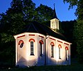
Maria-Hilf chapel
At the end of the 19th century, the Maria-Hilf-Chapel was built by the citizens of Weilheim. Doggererz was mined there until 1861 for the blast furnaces in Ludwigsthal . Women and children were forbidden from entering the 3.5 km long tunnel excavated by Untersteiger Bosch on June 13, 1857. The lighting is done with petroleum. Before starting work, the men stood around the hole and said an Our Father. The provisional assessor Steinheil archived in file E 244 Bü 96 on February 23, 1858 a floor plan and elevation of the status of the mine work in the iron stone seam near Weilheim, in black and red ink, in the format 57.7 × 64.8 cm , drawn.
The chapel has recently also shone in the spotlights at night.

Parish Church of St. George
Maria-Hilf chapel

New Year's Chapel

.jpg)

Economy and Infrastructure
traffic
Rietheim-Weilheim is located on the Gäubahn and has had a rail connection again since the ring train was introduced in 2003. There is one stop each in Rietheim and Weilheim. The ring train connects the two suburbs in time with Tuttlingen , Immendingen and Leipferdingen on the Wutachtalbahn . At Rottweil station , passengers traveling on the Ringzug have a connection to regional transport ( RE ) in the direction of Stuttgart or Singen. Rietheim-Weilheim is part of the TUTicket transport association .
Companies
The municipality is an important industrial location in the region with more than 2000 jobs and training positions, 1700 commuters and 600 outbound commuters. Rietheim-Weilheim is best known for the Marquardt Group , a manufacturer of switching and automotive systems, and WERMA Signaltechnik, a manufacturer of optical and acoustic signaling devices.
Tax rates
In 2012, the municipality had the lowest assessment rates in the entire Tuttlingen district for all three types of municipal tax: property tax A, property tax B and trade tax .
Personalities
- Erich Hauser (1930–2004), sculptor
- Ewald Marquardt (* 1931), entrepreneur
- Jakob Marquardt (1928–2007), entrepreneur
- Robin Haller (* 1986), handball player
Individual evidence
- ↑ State Statistical Office Baden-Württemberg - Population by nationality and gender on December 31, 2018 (CSV file) ( help on this ).
- ^ The state of Baden-Württemberg. Official description by district and municipality. Volume VI: Freiburg region Kohlhammer, Stuttgart 1982, ISBN 3-17-007174-2 . Pp. 680-681
- ^ Federal Statistical Office (ed.): Historical municipality directory for the Federal Republic of Germany. Name, border and key number changes in municipalities, counties and administrative districts from May 27, 1970 to December 31, 1982 . W. Kohlhammer, Stuttgart / Mainz 1983, ISBN 3-17-003263-1 , p. 518 .
- ↑ Result of the 2014 municipal council election , see also http://www.rietheim-weilheim.de/index.php?id=83
- ↑ Holdings B40 Bü1232 on Landesarchiv-BW.de
- ^ Inventory E 244 Bü 96 on Landesarchiv-BW.de
- ↑ Statistical reports Baden-Württemberg (edition of June 26, 2013) ( Memento of the original of February 22, 2014 in the Internet Archive ) Info: The archive link was inserted automatically and has not yet been checked. Please check the original and archive link according to the instructions and then remove this notice.
Web links

Aldingen | Balgheim | Bärenthal | Böttingen | Bubsheim | Buchheim | Deilingen | Denkingen | Dürbheim | Durchhausen | Egesheim | Emmingen-Liptingen | Fridingen an der Donau | Frittlingen | Geisingen | Gosheim | Gunningen | Hausen ob Verena | Immendingen | Irndorf | Kolbingen | Koenigsheim | Mahlstetten | Mühlheim an der Donau | Neuhausen ob Eck | Reichenbach am Heuberg | Renquishausen | Rietheim-Weilheim | Seitingen surface | Spaichingen | Talheim | Trossingen | Tuttlingen | Wehingen | Wormlings