Wurmlingen (Tuttlingen district)
| coat of arms | Germany map | |
|---|---|---|

|
Coordinates: 48 ° 0 ' N , 8 ° 47' E |
|
| Basic data | ||
| State : | Baden-Württemberg | |
| Administrative region : | Freiburg | |
| County : | Tuttlingen | |
| Height : | 665 m above sea level NHN | |
| Area : | 15.43 km 2 | |
| Residents: | 3812 (Dec. 31, 2018) | |
| Population density : | 247 inhabitants per km 2 | |
| Postal code : | 78573 | |
| Area code : | 07461 | |
| License plate : | DOES | |
| Community key : | 08 3 27 054 | |
| Address of the municipal administration: |
Obere Hauptstrasse 4 78573 Wurmlingen |
|
| Website : | ||
| Mayor : | Klaus Schellenberg ( CDU ) | |
| Location of the community of Wurmlingen in the Tuttlingen district | ||
Wurmlingen is a municipality in the Tuttlingen district in Baden-Württemberg . Apart from the village of the same name, no other localities belong to the municipality of Wurmlingen.
geography
Geographical location
The municipality of Wurmlingen is located near the confluence of the Faulenbach in the Elta in a wide basin of the western Swabian Alb directly at the 48th degree north latitude. The district area includes parts of the Faulenbach and Eltatals, which are located at an altitude of approx. 650 m above sea level. NHN are located, also parts of the plateau of the Swabian Alb (approx. 850 to 890 m above sea level ).
Neighboring communities
The community borders in the north on Rietheim-Weilheim , in the east and south on the district town of Tuttlingen and in the west on Seitingen-Oberflacht . The Wurmlingen district also touches the districts of four neighboring communities (Tuttlingen, Mühlheim an der Donau , Dürbheim and Rietheim-Weilheim) at a single point in Ursental .
history
Roman times: manor and Roman bath
In Wurmlingen there are the remains of a Roman manor and a Roman bath . At the time of the Great Migration , the Alemanni used this bath in connection with a wooden house, one of the rare specific uses of Roman facilities by the Teutons. The remains of the bath building are preserved under a protective house.
Middle Ages: Alemannic settlement and local foundation
In an Alemannic burial ground in the area of today's railway station Wurmlingen Mitte, the spear blade from Wurmlingen was recovered in 1929 (when the railway line was expanded to two tracks at that time) . Wurmlingen was first mentioned in a document on March 30, 797 in a deed of donation from the St. Gallen monastery as "Wurmeringa". The name goes back to the proper name Wurmhari or Wurmheri (cf. -ingen ). Wurmlingen Castle stood on the district .
A historical connection to Wurmlingen near Rottenburg could not be proven for a long time. However, a document indicates a connection: the brothers Albert, Friederich and Heinrich von Wurmlingen, known as the Hohin, lords of Wurmlingen and ministerials to the Counts of Zollern , sold their vineyard in Pfaffenberg (Kapellenberg) to Wurmlingen near Rottenburg on December 7, 1252 with the consent of her master, Count Friedrich von Zollern , to the Kirchberg convent .
Early modern times: Konzenberg rule
During the early modern period , Wurmlingen was the central place of the Konzenberg rule (cf. Konzenberg Castle ), which was owned by the cathedral chapter of the Diocese of Constance and, in addition to Wurmlingen, also included several neighboring villages. This centuries-long membership of the cathedral chapter still shapes the townscape today with its castle and the neo-classical St. Gallus church next to the simple old farmhouses that have long been used as residential houses. In 1803 Wurmlingen and Konzenberg fell to Baden , then in 1806 to Württemberg , with the administration by the Tuttlingen District Office .
Modern times
The rural character remained until the turn of the 20th century. Due to the strong growth of the leather processing and medical technology industry in nearby Tuttlingen since the completion of the Stuttgart – Tuttlingen – Singen railway , many residents have found jobs there. Notable industry developed in Wurmlingen itself only after the end of the Second World War, mostly from small-scale craft roots (graphic, paper processing industry, medical technology, automotive suppliers).
During the Baden-Württemberg regional reform in the early 1970s, Wurmlingen remained independent despite efforts by Tuttlingen to incorporate Wurmlingen. The favorable location on the outskirts of the prosperous industrial city of Tuttlingen and the growth of the local industrial companies enabled the municipality of Wurmlingen to develop prosperously with minimal per capita debt. The community has been debt free since 2002.
Events in recent history
On July 27, 1934, a Swissair passenger plane ( Curtiss AT-32C Condor CH-170) crashed into a wooded area ( Russberg ) east of the village. The plane was on its way from Zurich to Berlin . Among the twelve fatalities was the first stewardess in Europe, Nelly Diener .
politics
Administrative community
Wurmlingen belongs to the agreed administrative community of the city of Tuttlingen.
Municipal council
After the local elections on May 25, 2014, the municipal council has 14 members in addition to the mayor as chairman.
| CDU | 8 seats |
| BfW 1 | 6 seats |
1 citizen for wormlings
badges and flags
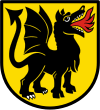
| Blazon : "In gold, a standing, fire-breathing black dragon, turned to the left." | |
| Justification for the coat of arms: The official seals used by the municipality in 1930 already contain the lindworm as a seal image, but without a shield. As a “talking” image for the place name, it was also suitable for a regular municipal coat of arms, the colors of which were determined by the municipality in 1935 at the suggestion of the Stuttgart archive department. The black and gold tinging is likely to have its model in the Württemberg colors. Wurmlingen, which belonged to the Konzenberg dominion until 1802, was swapped from Baden to Württemberg in 1806. |
 |
Banner: "The banner is black and yellow striped lengthways with the coat of arms above the middle." |
 |
Hoisted flag: "The flag has black and yellow stripes with the coat of arms in the middle." |
Culture and sights
The municipality is affiliated with the "Donaubergland" tourist association. Wurmlingen is located on the Neckar-Alb-Aare Roman road .
Buildings
- Roman bath (remains under a shelter)
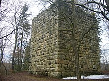
- Konzenberg ruins , 2 kilometers southwest of the village
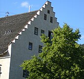
- The oldest building still in use is the so-called Hohbiehl (built around 1300) with its characteristic stepped gables .
- The former castle (built 1600–1602) now houses part of the local community school (Konzenbergschule).
- The so-called old bailiwick (originally built around 1500, demolished in 1985 and reconstructed true to the original) is used as a club house. There is a rural museum in the attic.
- Catholic St. Gallus Church, built 1782–1784 under the Fürstenberg master builder and court chamber councilor Franz Joseph Salzmann in the classicistic style.
Mardi Gras
Three characters play an important role in the Wurmlinger Fasnet : Hansele, Fox and Krattenweible. These emerged in the 1970s, e.g. Partly based on historical models: The Hansele is a white fool , the fox a "Blätzlenarr", who wears the colors green, yellow, blue and red. The largest group of the Wurmlinger fools are the Krattenweible.
Economy and Infrastructure
In addition to four companies with more than 100 employees, there are a large number of small businesses. The Hirsch Brewery Honer, founded in 1782, is regionally known .
The community has a total of 1200 jobs. Nevertheless, the number of in-commuters (880) is clearly exceeded by that of out-commuters (1050).
traffic
Wurmlingen is on federal highway 14 and on the Gäubahn . The trains of the ring train stop , which connect Wurmlingen every hour on weekdays with Tuttlingen , Immendingen , Leipferdingen as well as with Spaichingen and Rottweil . Wurmlingen is also connected to Tuttlingen city traffic by line 8 and is integrated into the TUTicket transport association . The station Tuttlingen is located about three kilometers from Wurmlinger town center.
Personalities
Sons and daughters of the church
- Fidelis Butsch (1805–1879), antiquarian
- Alfred Heizmann (1949–2017), teacher, dialect poet and carnival speaker
Personalities associated with the community
- Franz Egger (1882–1945), Catholic pastor, opponent of National Socialism; spent the last year of his life in Wurmlingen
- Hans Volle (* 1939), former district administrator of the Tuttlingen district; lives in Wurmlingen
Individual evidence
- ↑ State Statistical Office Baden-Württemberg - Population by nationality and gender on December 31, 2018 (CSV file) ( help on this ).
- ^ Description of the Tuttlingen Regional Office, Chapter B23 .
- ↑ See Ludwig Uhlands Schriften 8, 334 ff.
- ↑ quoted from leo-bw.de discover regional studies leobw .
- ^ District and municipal coats of arms in Baden-Württemberg Volume 3 Freiburg region, page 127 from 1989 ISBN 3-8062-0803-4


