
Aldingen
| coat of arms | Germany map | |
|---|---|---|

|
Coordinates: 48 ° 6 ' N , 8 ° 42' E |
|
| Basic data | ||
| State : | Baden-Württemberg | |
| Administrative region : | Freiburg | |
| County : | Tuttlingen | |
| Height : | 650 m above sea level NHN | |
| Area : | 22.17 km 2 | |
| Residents: | 7555 (December 31, 2018) | |
| Population density : | 341 inhabitants per km 2 | |
| Postal code : | 78554 | |
| Area code : | 07424 | |
| License plate : | DOES | |
| Community key : | 08 3 27 002 | |
| LOCODE : | DE ALN | |
| Address of the municipal administration: |
Marktplatz 2 78554 Aldingen |
|
| Website : | ||
| Mayor : | Ralf Fahrländer | |
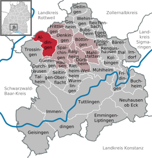
| Location of the municipality of Aldingen in the Tuttlingen district | ||
  |
||

Aldingen is the fourth largest municipality in the Tuttlingen district in Baden-Württemberg .
geography
Geographical location
Aldingen is 583 to 806 meters above sea level on the eastern edge of the Baar plateau at the foot of the Swabian Alb on the Prim .
Neighboring communities
The community borders the city of Rottweil and Frittlingen in the north, Denkingen in the east, the city of Spaichingen in the south and the city of Trossingen and Deißlingen in the Rottweil district in the west . The community is a member of the agreed administrative community of the city of Spaichingen.
Community structure
The municipality of Aldingen with the municipality of Aixheim , which was incorporated in 1975, includes six villages, hamlets, farms and houses. The village of Aixheim, the hamlet of Neuhaus and the houses Neueichhof, Neuhof and Täfermühle belong to the former municipality of Aixheim. The village of Aldingen and the desert areas Dellingen, Unterwahl and Winzingen are located in the municipality of Aldingen in the territory of 1974 . Amrizhausen, Heidenbühl and Ramsen are in the area of the former municipality of Aixheim .
climate
A weather station is operated in Aldingen. The annual mean temperature is around 8.2 degrees Celsius. The total precipitation amounts to 850 mm and the sun shines an average of 1700 hours per year. The climate can be classified as rather mild for this altitude.
history
Early history
As the ending -ingen suggests, Aldingen is an Alemannic settlement. During the restoration of the Mauritius Church, archaeological investigations uncovered findings that the settlement can be traced back to the 4th century. Post holes in a wooden church from around 700 were uncovered. A stone church was built on this site in the late 11th century.
The place was first mentioned in 802 or 803 in a deed of donation from the St. Gallen monastery . In 1444 Aldingen came to the then County of Württemberg and was assigned to the Tuttlingen office. Aldingen became a Protestant town in the period of the Reformation in 1534. Schlößlesbühl Castle was once located in the area .
Territory affiliation
In the Kingdom of Württemberg , the place was assigned to the Oberamt Spaichingen in 1810 . During the district reform during the Nazi era in Württemberg , the community came to the Tuttlingen district in 1938 . In 1945 the place became part of the French occupation zone and was thus assigned to the newly founded state of Württemberg-Hohenzollern , which was incorporated into the state of Baden-Württemberg in 1952.
Incorporations
On January 1, 1975, the previously independent community of Aixheim was incorporated into Aldingen.
religion
The Protestant parish includes the parishes of Aldingen, Aixheim, Denkingen and Frittlingen. Since 1964 there is again a Catholic church in Aldingen with a Catholic parish since 1980. The Catholic parish of Aldingen is organized in the pastoral care unit Klippeneck-Primtal.
Since 2003 there has been a mosque for the Islamic citizens of the area in the neighboring town of Spaichingen.
politics
Municipal council
The municipal council consists of the elected voluntary councilors and the mayor as chairman. The mayor is entitled to vote in the municipal council.
The local elections on May 26, 2019 led to the following preliminary final result.
| Parties and constituencies |
% 2019 |
Seats 2019 |
% 2014 |
Seats 2014 |
% 2009 |
Seats 2009 |
||
| FW | Free voters | 42.3 | 7th | 41.9 | 7th | 42.4 | 8th | |
| CDU | Christian Democratic Union of Germany | 36.8 | 7th | 37.5 | 7th | 42.6 | 8th | |
| SPD | Social Democratic Party of Germany | 20.9 | 4th | 20.6 | 4th | 15.0 | 2 | |
| total | 100.0 | 18th | 100.0 | 18th | 100.0 | 18th | ||
| voter turnout | 49.6% | 44.6% | 46.8% | |||||
mayor
| Banner, coat of arms and flag | |

|

|

|
|
In December 2013 Ralf Fahrländer succeeded Reinhard Lindner. He had held the office for 35 years.
badges and flags
Blazon : "In gold (yellow) a green linden tree on green ground." Heraldically correct it should read: "In gold (yellow) on a green hill a green linden tree."
Justification of the coat of arms: The coat of arms awarded in 1930 is derived from the oldest seal image of the place from 1797, which showed a deciduous tree accompanied by four stars with a stag pole placed across the trunk, including two diagonally crossed branches. The meaning of the linden tree is unclear. Proof of a previous place of jurisdiction could not be found.
Flag: The banner or the hoist flag is green-yellow stripes lengthways or crossways with the coat of arms above or in the middle. The flag was awarded on August 17, 1970 by the Ministry of the Interior.
Culture and sights
The municipality is affiliated with the "Donaubergland" tourist association.
Museum and community meeting place in Aldingen
Since 2002 there has been a museum and community meeting place for local history in Aldingen .
Economy and Infrastructure
Aldingen is an industrial community. Mainly metal processing companies are located here, but there are also electronic and electrotechnical companies as well as companies for tool and apparatus construction. The skilled trades and specialist retailers are also represented by high-performance businesses.
traffic

Aldingen is located on the Gäubahn and has been a train stop again since the ring train was introduced in 2003. The Aldingen station, which was closed for passenger traffic in 1977, is today one of the most successful ring train stops, where around 1000 passengers get on and off every working day. The high number of passengers at Aldingen train station can also be attributed to the fact that Aldingen is an important link between the ring train and bus services. In Aldingen, where the ring trains from the direction of Rottweil intersect with those from the direction of Tuttlingen at minute 30, bus services to Trossingen and the Heuberg are offered shortly after the arrival of the ring trains . Every working day, the ring train connects Aldingen every hour with Rottweil, where there is an intercity connection to Stuttgart every two hours , as well as with Spaichingen, Tuttlingen, Immendingen and Leipferdingen . Aldingen is part of the TUTicket transport association .
Aldingen is on the federal highway 14 between Rottweil and Tuttlingen. This provides a good connection to the neighboring city of Spaichingen. State and district roads connect the community with Trossingen, Schura , Aixheim and Denkingen.
Sons and daughters of the church

- Berchtold Haller (1492–1536), reformer of the city of Bern
- Link brothers : Johann Link (1821–1871) and Paul Link (1821–1891), organ builders
literature
- Helmut Müller (Ed.): Mauritius Church Aldingen. Aldingen, 1979, 141 pp.
Web links
Individual evidence
- ↑ State Statistical Office Baden-Württemberg - Population by nationality and gender on December 31, 2018 (CSV file) ( help on this ).
- ^ The state of Baden-Württemberg. Official description by district and municipality. Volume VI: Freiburg District Kohlhammer, Stuttgart 1982, ISBN 3-17-007174-2 , pp. 654–656.
- ^ Claus Ahrens: The early wooden churches of Europe. Darmstadt 2001, p. 6.
- ↑ StiASG , Urk. I 159. Online at e-chartae , accessed on June 12, 2020.
- ^ Federal Statistical Office (ed.): Historical municipality directory for the Federal Republic of Germany. Name, border and key number changes in municipalities, counties and administrative districts from May 27, 1970 to December 31, 1982 . W. Kohlhammer, Stuttgart / Mainz 1983, ISBN 3-17-003263-1 , p. 518 .
- ↑ Preliminary final result of the Aldingen municipal council election 2019
- ↑ http://www.schwaebische.de/region_artikel,-969-Prozent-fuer-Ralf-Fahrlaender-_arid,5544392_toid,685.html
- ↑ Description of the coat of arms
- ^ Flag of the municipality of Aldingen

Aldingen | Balgheim | Bärenthal | Böttingen | Bubsheim | Buchheim | Deilingen | Denkingen | Dürbheim | Durchhausen | Egesheim | Emmingen-Liptingen | Fridingen an der Donau | Frittlingen | Geisingen | Gosheim | Gunningen | Hausen ob Verena | Immendingen | Irndorf | Kolbingen | Koenigsheim | Mahlstetten | Mühlheim an der Donau | Neuhausen ob Eck | Reichenbach am Heuberg | Renquishausen | Rietheim-Weilheim | Seitingen surface | Spaichingen | Talheim | Trossingen | Tuttlingen | Wehingen | Wormlings