
Talheim (Tuttlingen district)
| coat of arms | Germany map | |
|---|---|---|
_COA.svg)
|
Coordinates: 48 ° 1 ′ N , 8 ° 40 ′ E |
|
| Basic data | ||
| State : | Baden-Württemberg | |
| Administrative region : | Freiburg | |
| County : | Tuttlingen | |
| Height : | 755 m above sea level NHN | |
| Area : | 13.12 km 2 | |
| Residents: | 1224 (December 31, 2018) | |
| Population density : | 93 inhabitants per km 2 | |
| Postal code : | 78607 | |
| Area code : | 07464 | |
| License plate : | DOES | |
| Community key : | 08 3 27 048 | |
| Address of the municipal administration: |
Kirchbrunnen 6 78607 Talheim |
|
| Website : | ||
| Mayor : | Martin Hall | |
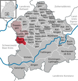
| Location of the municipality of Talheim in the Tuttlingen district | ||
  |
||

Talheim is a municipality in the district of Tuttlingen in Baden-Württemberg with around 2500 inhabitants.
geography
Geographical location
Talheim is located on the eastern edge of the Baar plateau at the foot of the 977 meter high Lupfen , the westernmost foothill of the Swabian Alb . On the other side (south) is the 940 meter high Himmelberg, which already belongs to the Bad Dürrheim district of Öfingen . Seitingen-Oberflacht is located directly to the north behind the Lupfen
Neighboring communities
The community borders in the north on Durchhausen , in the east on the Oberflacht district of the Seitingen-Oberflacht community , in the southeast on the Eßlingen district of the district town of Tuttlingen , in the south on the Immendingen district of Ippingen and in the west on the Öfingen district of the spa town of Bad Dürrheim and on Tuningen , both in the Schwarzwald-Baar district .
Community structure
The municipality of Talheim includes the village of Talheim and the Götzenlocher Hof, Obere Mühle and Untere Mühle farms. In the municipality which are deserted villages Asp and Ötishofen and dialed castles Burg Klingenberg , Lupfen and Reifenberg .
history

Talheim was first mentioned in a document as Talhan in 973 . The place belonged to the Counts of Lupfen . In disputes with the emperor, the counts lost their rights and the village came to the Lords of Friedingen via the Free Imperial City of Rottweil , who sold it to Württemberg in 1444 . Since then, Talheim has been part of Württemberg without interruption.
Talheim was incorporated into the city of Trossingen by a state law on January 1, 1975. The municipality brought an action against this law before the Baden-Württemberg State Court , which declared it to be invalid by judgment of April 2, 1976. Talheim was thus independent again and subsequently voluntarily entered into an agreed administrative partnership with the city of Trossingen .
politics
mayor
On October 24, 2004, Martin Hall was elected Mayor of Talheim with around 45 percent of the vote in the second ballot, with a turnout of 75.3 percent. Hall succeeded Manfred Härle, who was elected Mayor of Salem on March 28, 2004 . He had held the office since 2001, succeeding Helmut Fröhlich, who had not stood for election after four terms in office.
- 1919–1945: Martin Kohler (WBWB, NSDAP)
- 1945–1965: Wilhelm Ulrich
- 1966–2001: Helmut Fröhlich (SPD)
- 2001-2004: Manfred Härle (CDU)
- since 2004: Martin Hall
coat of arms
|
|
Blazon : "In gold (yellow) a rooted green fir, the trunk of which is covered by a standing red cattle." |
| Justification of the coat of arms: The coat of arms last approved by the Ministry of the Interior on November 3, 1964 is derived from a mayor's office seal from 1930, which showed the beef and the fir in the oval seal field. The motifs remind of the agricultural character of the community to this day. |
Banner and flag
.svg) |
Banner: "The banner is yellow-red striped lengthways with the coat of arms above the middle." |
.svg) |
Hoisted flag: "The flag has yellow and red stripes with the coat of arms in the middle." |
Culture and sights
The municipality is affiliated with the "Donaubergland" tourist association. Talheim has a swimming lake, a local museum, a fishing pond and allotments.
Personalities
Sons and daughters of the church
- Matthias Schneckenburger (1804–1848), Protestant theologian, professor in Bern
- Max Schneckenburger (1819–1849), poet of the patriotic song Die Wacht am Rhein
- Johann Martin Vosseler (1842–1905), member of the Württemberg state parliament
- Martin Kohler (1894–1973), politician (WBWB, NSDAP), member of the Reichstag and Landtag
Individual evidence
- ↑ State Statistical Office Baden-Württemberg - Population by nationality and gender on December 31, 2018 (CSV file) ( help on this ).
- ^ The state of Baden-Württemberg. Official description by district and municipality. Volume VI: Freiburg region Kohlhammer, Stuttgart 1982, ISBN 3-17-007174-2 . Pp. 668-669
- ^ Federal Statistical Office (ed.): Historical municipality directory for the Federal Republic of Germany. Name, border and key number changes in municipalities, counties and administrative districts from May 27, 1970 to December 31, 1982 . W. Kohlhammer, Stuttgart / Mainz 1983, ISBN 3-17-003263-1 , p. 518 and 535 .
- ↑ cas / dim: Hall follows Härle . In: Südkurier from October 25, 2004
Web links

Aldingen | Balgheim | Bärenthal | Böttingen | Bubsheim | Buchheim | Deilingen | Denkingen | Dürbheim | Durchhausen | Egesheim | Emmingen-Liptingen | Fridingen an der Donau | Frittlingen | Geisingen | Gosheim | Gunningen | Hausen ob Verena | Immendingen | Irndorf | Kolbingen | Koenigsheim | Mahlstetten | Mühlheim an der Donau | Neuhausen ob Eck | Reichenbach am Heuberg | Renquishausen | Rietheim-Weilheim | Seitingen surface | Spaichingen | Talheim | Trossingen | Tuttlingen | Wehingen | Wormlings