
Klingenberg Castle (Talheim)
| Klingenberg ruins | ||
|---|---|---|
 |
||
| Alternative name (s): | Reiffenberg Castle | |
| Creation time : | Second half of the 13th century | |
| Castle type : | Höhenburg, hillside location | |
| Conservation status: | Ramparts and ditches | |
| Place: | Talheim - "Reifenberg" | |
| Geographical location | 48 ° 0 '9.6 " N , 8 ° 41' 4" E | |
| Height: | 799.7 m above sea level NN | |
|
||

The former Klingenberg Castle , whose historical name was Reiffenberg , is the stable of a hilltop castle on the Reifenberg, 1960 meters south-east of the church of Talheim in the Tuttlingen district in Baden-Württemberg .
Geographical location
On the K 5944 east of Talheim at "Unterer Mühle" there is an underpass under the B 523. At the forest, follow the eastern path over the Reifenberg towards the west. Shortly after a cut with a brook, the path turns north. There the ruins are located at 799.7 m, around 40 meters east of the path in the forest.
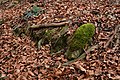
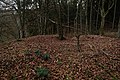
Today ramparts and moats still exist from the former castle complex .
history
Reiffenberg Castle, built during the second half of the 13th century, the castle name Klingenberg is not historically documented, was the seat of the Lords of Reiffenberg named after the castle and mentioned between 1268 and 1395. They were servants of the barons von Wartenberg and those of the Fürstenbergers . The Reiffenberg settlement, which has now disappeared, was located below the castle complex. The castle, which was presumably sold before the middle of the 14th century, was sold in 1437 as the "Burgstall" including accessories by the Counts of Lupfen to Heinrich and Rudolf von Friedingen. In 1444 it was owned by Württemberg . Around the year 1600 it was called again as Burgstall.
description
The roughly square, around 25 × 28 meters large and about 700 square meters measuring castle site is 799.7 m above sea level. NN height on a small ledge in the lower slope area on the northeast corner of the tire mountain. The east side of the castle plateau drops steeply to the valley of the Krähenbach , on the remaining sides the terrain rises to 947.6 m above sea level. NN high summit of the tire mountain, and was poorly protected here by nature. To protect the castle complex , a U-shaped ditch up to 20 meters wide and nine meters deep was created on these sides as an approach obstacle.
On the castle plateau, some remains of former buildings can still be seen, on the western side, which is most endangered by the elevation of the foreland, there was a probably trapezoidal or square, tower-shaped building. This building had a side length of nine to ten meters and an internal area of probably around 30 to 35 square meters. In addition, traces of other buildings have been preserved, including a circular wall in the form of ramparts running around the edges of the castle plateau. The earlier access to the castle was probably near the tower. There are no known readings from the castle complex, apart from the remains of bricks.
photos

dig

Stone in the ditch

Rest of the curtain wall
Rest of the curtain wall
On the castle stables


literature
- Max Miller , Gerhard Taddey (ed.): Handbook of the historical sites of Germany . Volume 6: Baden-Württemberg (= Kröner's pocket edition . Volume 276). 2nd, improved and enlarged edition. Kröner, Stuttgart 1980, ISBN 3-520-27602-X .
- Hans-Wilhelm Heine: Studies on weir systems between the young Danube and western Lake Constance . In: Landesdenkmalamt Baden-Württemberg (Hrsg.): Research and reports on the archeology of the Middle Ages in Baden-Württemberg. Volume 5 . Stuttgart 1978, ISSN 0178-3262 , pp. 105-106 and 156.
Web links
Individual evidence
- ^ Source history: Hans-Wilhelm Heine: Studies on weir systems between the young Danube and western Lake Constance , p. 105
- ^ Source history: Hans-Wilhelm Heine: Studies on weir systems between the young Danube and western Lake Constance , pp. 105 and 156


Castles: Jagdschloss Bachzimmer | Balgheim Castle | Bronnen Castle | Emmingen Castle | Ensisheim Palace | Ifflinger Schloss (Fridingen Castle) | Geisingen Castle | Lower Castle (Immendingen) | Upper Castle (Immendingen) | Möhringen Castle (Old and New Castle) | Mühlheim rear castle | Front Mühlheim Castle | Neuhohenberg Castle (Granegg Castle) | Rietheim Castle (Upper Castle) | Wartenberg Castle | Wurmlingen Castle
Castles and ruins: Burgstall Aixheim | Castle ruins Altfridingen | Altrietheim Castle | Amtenhausen Castle | Burgstelle Bachtal | Baldenberg Castle | Bärenthal castle ruins | Castle ruins Bräunisburg (Neuwartenberg) | Burghalde Dürbheim | Burghalde Kolbingen | Castle ruins Burgstall | Castle ruins Burgstallhöhle | Darrendobel Castle | Durchhausen Castle | Ehrenburg | Espach Castle (Freudeneck) | Fürstenstein Castle | Geisingen Castle (Gisingen) | Court Customs Castle | Granegg castle ruins | Heidenburg (Geisingen) | Heidenburg (Bachzimmer) | Heidenburg (Ippingen) | Hewenegg Castle | Burgrest Hewenegg | Hohenkarpfen Castle | Hohenlupfen Castle | Homburg | Castle ruins Honberg | Section attachment Hörnekapf | Immendingen Castle | Burghöhle Kaiserstandfelsen (cave at Scheuerlehof) | Kallenberg castle ruins | Klingenberg Castle | Kolbingen Castle | Konzenberg Castle | Kraftstein castle ruins | Krinnerfels Castle | Lehenbühl Castle | Leipferdingen Castle | Lengenfels castle remains | Castle ruin Luginsfeld | Burgstelle Möhringen | Neuhausen Castle | Neu-Sunthausen Castle | Reifenberg Castle | Rietheim Castle | Rockenbusch castle remains | Schallon Castle | Section reinforcement Schänzle | Schänzle | Schenkenberg Castle | Schlößlesbühl Castle | Castle ruins Schwandorf | Spaltfels Castle | Burgstall stone | Stiegelesfels castle ruins | Trossingen Castle (Sattlersbühl) | Castle Wallenburg | Walterstein Castle | Wartenberg castle ruins | Wartenberg Castle (Alt-Wartenberg) | Castle ruins Wasserburg | Wehingen castle ruins (Harrasburg) | Weststätten Castle | Wurmlingen Castle (Schanze on the Aienbuch) | Ziegelhöhlenburg castle ruins