
Konzenberg Castle
| Konzenberg Castle | ||
|---|---|---|
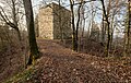
 Konzenberg Castle - View of the keep |
||
| Castle type : | Höhenburg, spur location | |
| Conservation status: | ruin | |
| Standing position : | Free nobles | |
| Construction: | Humpback cuboid | |
| Place: | Wormlings | |
| Geographical location | 47 ° 59 '20 " N , 8 ° 44' 43" E | |
| Height: | 783.2 m above sea level NN | |
|
||

The castle Konzenberg is the ruin of a Spur castle at 783.2 m above sea level. NN in the area of the municipality of Wurmlingen near Tuttlingen in the Tuttlingen district .
Geographical location
The Konzenberg ruins are located about 2 kilometers east of Eßlingen and 3 kilometers southwest of Wurmlingen on a spur pointing to west-northwest, which is bordered by the Eltatal in the north and by the brook valley formed by the Krähenbach in the southwest .
history

The castle was built in the high Middle Ages, probably by the noble free von Wartenberg . It was first mentioned in a document in 1239 and at that time it was already in the possession of the noble noblemen of Hirschegg, whose father had married Prince Konrad I. Udilhild von Wartenberg.
Konrad Prince of Konzenberg III. In 1300 he sold the castle and its accessories to Bishop Heinrich II of Konstanz, who in 1301 acquired the jurisdiction (Vogtei) Wurmlingen (with Weilheim ) and part of the Vogtei von Frittlingen and made it the dominion of Konzenberg .
In 1460, the Bailiwick of Wurmlingen with the Konzenberg Fortress was pledged by the Constance Monastery to the Constance Dompropstei, which united it with the neighboring property of the Dompropst and administered it uniformly from Wurmlingen. In 1614, the Dompropstei acquired the property of the lordship, including the Konzenberg Castle, which was used as a prison at times, and which was then secularized in 1802/03 . In 1820 the castle was sold for demolition and later turned into ruins.
The remainder of the keep of the castle consists of mighty limestone - humpback ashlars .
description
The remains of a massive donjon , remains of the surrounding wall and trenches , some 13 meters high, exist from the castle, some of which are provided with ramparts.
The keep has a base area of about 12 by 13 meters and 4 meters thick walls. Its access is about 10 meters above sea level. It was built from hump blocks from the Hegau, and one corner stone has a coat of arms.
The surrounding wall forms a slender trapezoid , the length of which on the spur sides is a little more than 50 meters. The walls securing the spur area and the spur tip are about 16 meters (spur tip) and 23 meters (spur side) long. The surrounding wall is covered in the interior with the exception of a few stone remains. Parts of the masonry can still be seen from the outside.
The complex is enclosed by trenches, the neck trenches are significantly deeper than the trenches on the sides of the spur.
The spur side of the castle was also protected by a fore. The spur was secured by a wall with a ditch about 150 meters from the neck ditch. The spur sides from this wall up to the neck ditch were also secured with ramparts and ditches, whereby the outwork was made considerably lower than the fortification of the castle. The western and northern ramparts of the Vorwerk are now broken through by forest paths.
Access to the ruin is via a path from the north over the neck ditch, or via a recent forest path from the spur area.
photos

Keep with access

Coat of arms on the keep

Hewn humpback blocks

Inner courtyard with remains of the surrounding wall

Wall remains of the surrounding wall
Access, to the right and left of it the neck ditch

Ditch and rampart towards Bächetal

Ditch and rampart of the Vorwerk towards Bächetal


literature
- Arthur Hauptmann: Castles then and now - castles and castle ruins in southern Baden and neighboring areas . Verlag Südkurier, Konstanz 1984, ISBN 3-87799-040-1 , pp. 231-234.
- Hans-Wilhelm Heine : Studies on weir systems between the young Danube and western Lake Constance . In: Landesdenkmalamt Baden-Württemberg (Hrsg.): Research and reports on the archeology of the Middle Ages in Baden-Württemberg. Volume 5 . Stuttgart 1978, ISSN 0178-3262 , p. 110.
- Max Miller (ed.): Handbook of the historical sites of Germany . Volume 6: Baden-Württemberg (= Kröner's pocket edition . Volume 276). Kröner, Stuttgart 1965, DNB 456882928 , p. 763.
Web links
- Schummerungskarte Source: LGL, www.lgl-bw.de
- Konzenberg Castle at www.alleburgen.de
- Konzenberg Castle at www.burgenwelt.org


Castles: Jagdschloss Bachzimmer | Balgheim Castle | Bronnen Castle | Emmingen Castle | Ensisheim Palace | Ifflinger Schloss (Fridingen Castle) | Geisingen Castle | Lower Castle (Immendingen) | Upper Castle (Immendingen) | Möhringen Castle (Old and New Castle) | Mühlheim rear castle | Front Mühlheim Castle | Neuhohenberg Castle (Granegg Castle) | Rietheim Castle (Upper Castle) | Wartenberg Castle | Wurmlingen Castle
Castles and ruins: Burgstall Aixheim | Castle ruins Altfridingen | Altrietheim Castle | Amtenhausen Castle | Burgstelle Bachtal | Baldenberg Castle | Bärenthal castle ruins | Castle ruins Bräunisburg (Neuwartenberg) | Burghalde Dürbheim | Burghalde Kolbingen | Castle ruins Burgstall | Castle ruins Burgstallhöhle | Darrendobel Castle | Durchhausen Castle | Ehrenburg | Espach Castle (Freudeneck) | Fürstenstein Castle | Geisingen Castle (Gisingen) | Court Customs Castle | Granegg castle ruins | Heidenburg (Geisingen) | Heidenburg (Bachzimmer) | Heidenburg (Ippingen) | Hewenegg Castle | Burgrest Hewenegg | Hohenkarpfen Castle | Hohenlupfen Castle | Homburg | Castle ruins Honberg | Section attachment Hörnekapf | Immendingen Castle | Burghöhle Kaiserstandfelsen (cave at Scheuerlehof) | Kallenberg castle ruins | Klingenberg Castle | Kolbingen Castle | Konzenberg Castle | Kraftstein castle ruins | Krinnerfels Castle | Lehenbühl Castle | Leipferdingen Castle | Lengenfels castle remains | Castle ruin Luginsfeld | Burgstelle Möhringen | Neuhausen Castle | Neu-Sunthausen Castle | Reifenberg Castle | Rietheim Castle | Rockenbusch castle remains | Schallon Castle | Section reinforcement Schänzle | Schänzle | Schenkenberg Castle | Schlößlesbühl Castle | Castle ruins Schwandorf | Spaltfels Castle | Burgstall stone | Stiegelesfels castle ruins | Trossingen Castle (Sattlersbühl) | Castle Wallenburg | Walterstein Castle | Wartenberg castle ruins | Wartenberg Castle (Alt-Wartenberg) | Castle ruins Wasserburg | Wehingen castle ruins (Harrasburg) | Weststätten Castle | Wurmlingen Castle (Schanze on the Aienbuch) | Ziegelhöhlenburg castle ruins