Aixheim
|
Aixheim
Aldingen municipality
|
|
|---|---|
| Coordinates: 48 ° 6 ′ 30 ″ N , 8 ° 40 ′ 37 ″ E | |
| Height : | 664 m above sea level NN |
| Residents : | 1243 (2016) |
| Incorporation : | 1st January 1975 |
| Postal code : | 78554 |
| Area code : | 07424 |
Aixheim is a district of the municipality of Aldingen in the northern district of Tuttlingen in Baden-Württemberg .
geography
Geographical location
Aixheim is located at the eastern end of the Baar on the edge of the Swabian Alb , about two kilometers northwest of Aldingen and five kilometers northeast of Trossingen , at an altitude of 664 m above sea level. NN and has 1285 inhabitants (as of January 31, 2012).
history
The place was first mentioned by name in 1086 as Aichcshain, later as Aidisain . In the Middle Ages, the Rottenmünster monastery gained control of most of the village and, in 1624, also high jurisdiction . After the secularization of the monastery, Aixheim became part of Württemberg in 1803 . The place was an independent municipality in the Württemberg Oberamt Spaichingen , since 1938 in the Tuttlingen district. As part of the Baden-Württemberg regional reform , Aixheim was incorporated into Aldingen on January 1, 1975.
politics
coat of arms
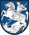
| Blazon : "In blue a silver St. George on a silver horse, fighting a silver dragon" | |
Culture and sights
Buildings
- The Burgstall Aixheim describes a castle that was probably built around 1000 by the local nobility of Aixheim , whose moats were still visible in the 19th century.
Economy and Infrastructure
The agriculture still plays a role in Aixheim, although crafts and trade were located. However, the vast majority of those in work commute to work outside the town.
education
Aixheim has a Catholic rectory, a Catholic kindergarten and a primary school .
leisure
The sports facilities in Aixheim include a rifle house, a sports field with a sports center, a skater area and a gymnasium and festival hall.
Web links
- Ortschronik ( Memento from September 29, 2007 in the Internet Archive )
Individual evidence
- ↑ Numbers, data, facts ( Memento from May 9, 2016 in the Internet Archive ), aldingen.de, accessed March 20, 2016
- ^ Federal Statistical Office (ed.): Historical municipality directory for the Federal Republic of Germany. Name, border and key number changes in municipalities, counties and administrative districts from May 27, 1970 to December 31, 1982 . W. Kohlhammer, Stuttgart / Mainz 1983, ISBN 3-17-003263-1 , p. 518 .

