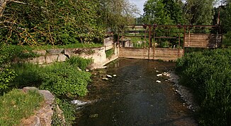
Faulenbach (Elta)
| Faulenbach | ||
|
Estuary into the Elta |
||
| Data | ||
| Water code | DE : 11144 | |
| location |
Swabian Alb
|
|
| River system | Danube | |
| Drain over | Elta → Danube → Black Sea | |
| origin | 1 km west of Dürbheim 48 ° 3 ′ 19 ″ N , 8 ° 46 ′ 35 ″ E |
|
| Source height | approx. 695 m above sea level NHN | |
| muzzle | in Wurmlingen from the left into the Elta coordinates: 47 ° 59 '50 " N , 8 ° 46' 48" E 47 ° 59 '50 " N , 8 ° 46' 48" E |
|
| Mouth height | approx. 657 m above sea level NHN | |
| Height difference | approx. 38 m | |
| Bottom slope | approx. 4.7 ‰ | |
| length | 8 kilometers | |
| Catchment area | 28.362 km² | |
| Flowing lakes | Egelsee | |
The Faulenbach is an 8 km long left and northern tributary of the Danube flowing Elta in Baden-Wuerttemberg .
geography
course
The Faulenbach rises in the Dürbheimer Moor , about one kilometer west of the municipality of Dürbheim on the municipal boundary to Balgheim , which lies on the other side of the European main watershed , around which the headwaters of the Neckar tributary Prim lies. The Faulenbach flows south in a wide valley, crosses the village of Rietheim and passes the village of Weilheim in the municipality of Rietheim-Weilheim on the eastern edge . It then reaches Wurmlingen . There it flows south of the town center after 8.0 km from the left into the Elta, which joins the Danube just two kilometers further down.
Catchment area
Large parts of the stream and the eastern part of the mostly narrower, 28.4 km² catchment area on this side lie in the Upper Danube Nature Park . The largest part of the natural area belonging to the subunit Baar-Alb and Upper Danube Valley of the Swabian Alb lies in water protection areas. On the north-eastern edge there is a strip of the Dürbheimer Berg protected landscape area . The 54 hectare nature reserve Dürbheimer Moor encompasses the valley from in front of the Egelsee to the old fish ponds south of Dürbheim.
Tributaries and lakes
From the source to the mouth. Selection.
-
 Flows through the Egelsee west of Dürbheim, 7.3 ha
 - Mühlbach , from the left and northeast from Dürbheim, 1.7 km
-
 Passes old fish ponds on the left of the river south of Dürbheim, by far the largest with 0.9 ha
 - Bear pit, from the right and west in northern Würmlingen, 1.8 km
Individual evidence
- ↑ a b c d e f State Institute for the Environment Baden-Württemberg (LUBW) ( notes )
- ↑ Friedrich Huttenlocher : Geographical Land Survey: The natural space units on sheet 178 Sigmaringen. Federal Institute for Regional Studies, Bad Godesberg 1959. → Online map (PDF; 4.3 MB)
- ^ Alfred G. Benzing: Geographical land survey: The natural space units on sheet 186 Konstanz. Federal Institute for Regional Studies, Bad Godesberg 1964. → Online map (PDF; 4.1 MB)
literature
- Topographic map 1: 25,000 Baden-Württemberg, as single sheet No. 7918 Spaichingen and No. 8018 Tuttlingen
Web links
- Map of the course and catchment area of the Faulenbach on: State Institute for the Environment Baden-Württemberg (LUBW) ( information )
- Map of the course and catchment area of the Faulenbach on: Geoportal Baden-Württemberg ( information )
- Measuring table sheet 7918 Spaichingen from 1912 in the Deutsche Fotothek
