Bear
|
Bära upper reaches Upper Bära, Lower Bära |
||
|
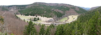
View to the northwest from the Kreidenstein ruins into the Bäratal, which runs from right to left |
||
| Data | ||
| Water code | EN : 1116 | |
| location |
Upper Danube Nature Park
|
|
| River system | Danube | |
| Drain over | Danube → Black Sea | |
|
Sources ( headwaters ) |
Upper Bära in Tieringen 48 ° 11 ′ 47 " N , 8 ° 52 ′ 37" E Lower Bära near Gosheim 48 ° 8 ′ 32 " N , 8 ° 44 ′ 58" E |
|
| Source height | approx. 833 m above sea level NN Lower Bear
|
|
| muzzle | In Fridingen in the Danube coordinates: 48 ° 1 ′ 44 ″ N , 8 ° 56 ′ 4 ″ E 48 ° 1 ′ 44 ″ N , 8 ° 56 ′ 4 ″ E |
|
| Mouth height | 622.6 m above sea level NN | |
| Height difference | approx. 210.4 m | |
| Bottom slope | approx. 8 ‰ | |
| length | 26.3 km with right upper reaches Untere Bära |
|
| Catchment area | 134.5 km² | |
| Discharge at the gauge Fridingen A Eo : 134 km² Location: 1.2 km above the mouth |
NNQ (08/26/1998) MNQ 1938–2006 MQ 1938–2006 Mq 1938–2006 MHQ 1938–2006 HHQ (05/23/1978) |
64 l / s 259 l / s 1.78 m³ / s 13.3 l / (s km²) 18.2 m³ / s 60.3 m³ / s |
The Bara is the head waters of the lower natural environment High Schwabenalb the Swabian Alb in Baden-Wuerttemberg districts Zollernalbkreis and Tuttlingen and ends on the last Baaralb in Fridingen from the left and from the northwest to the north into the Danube .
It arises from the confluence of the left Upper Bära and the right Lower Bära . The Bära, which is 12.7 kilometers long from this point, comes together with its longer and slightly more catchment-rich upper reaches of the Untere Bära to 26.3 kilometers.
Geology and river history
The bear is an ancient river. The Ur-Bära is probably even older than the Urdonau . It poured its water and the river gravel (“Juranagelfluh” gravel) into the barley sand channel , which was the main drainage channel before the Danube was formed. In the past, every now and then very large Bära body of water created a wide, deep valley.
Upper Bear
The Obere Bära rises in the west of the Swabian Alb , directly on the European main watershed , near the Alb eaves at the Meßstetter village of Tieringen . Just half a kilometer northwest of its uppermost course, the young Schischem , which drains over the Neckar to the Rhine, pulls its headwaters to the northwest on the other edge of the village of Tieringen.
The Obere Bära runs 12.8 kilometers south, drains an area of 50.9 km² on the surface and crosses the following municipalities and cities:
- Tieringen (district of Meßstetten )
- Oberdigisheim (district of Meßstetten)
- Unterdigisheim (district of Meßstetten)
- Nusplingen
Tributaries
- from the source to the confluence.
The highest source of the Upper Bära at less than 850 m above sea level. NHN on the eastern edge of Tieringen on the path of the K 7143 to Meßstetten - Hossingen . From here the Obere Bära flows the first three quarters of a kilometer down the slope to the southwest, as soon as it has reached the middle of the valley range that is divided with the Schlicher, then initially southeast.
- Fohbach , from the right to below 785 m above sea level. NHN halfway to Oberdigisheim, 1.9 km. Arises from a source of forest blades at Heidenhof.
- Kohlstattbrunnenbach , from the right to 770.2 m above sea level. NN in Oberdigisheim, 3.8 km and 8.0 km². Rises at around 870 m above sea level. NHN of the source Kohlstattbrunnen in a forest blade west of Geyerbad. Runs through something before the beginning of Obderdigisheim at less than 800 m above sea level. NHN a reservoir, 3.5 hectares. It also flows a little downwards via a short flood relief channel going off in the center of the village and twisted in the settlement area.
- Burtelbach , from the left to almost 750 m above sea level. NHN in Unterdigisheim, 2.9 km and 12.7 km². Arises at over 805 m above sea level. NHN in a damp valley floor south of Hossingen and soon after experiences brief inflow from other sources on the floor of a side valley.
- Sägebach , from the right to 720.8 m above sea level. NN in the beginning of Nusplingen. 0.4 km and 3.7 km². Arises at about 750 m above sea level. NHN at the foot of the slope of the Upper Bära Valley immediately after a short dry valley.
- Tellenbach , from the right to over 715 m above sea level. NHN in Nusplingen, 0.7 km and 3.4 km². Arises at about 750 m above sea level. NHN at the foot of the slope under the Uhufelsen directly in front of an approaching dry valley.
- (Two inlets from the Hagenbrunnen at the foot of the slope), from the left above and below the river bridge in the village, both 0.2 km. Arise at over 740 m above sea level. NHN .
- Rauzenbach / Abendbach, from the right to about 713 m above sea level. NHN in Nusplingen, 0.5 km. Arises at a little over 750 m above sea level. NHN at the foot of the slope under the fir rock on the southern edge of the dry valley mouth. Also has a flood discharge that flows further down the valley.
- (Exit of an engine duct), to the right. Takes up further spring foot springs and flows after 1.0 km shortly before the confluence of the two Bära upper reaches from the left into the Lower Bära.
Confluence with the right and longer Lower Bära on the Galgenwiesen at almost 690 m above sea level. NHN .
Lower bear
The Untere Bära rises north of the outskirts of Gosheim at the southern foot of the Lemberg , the highest mountain in the Swabian Alb. Here, too, the origin is close to the major watershed, the less significant competition on the other side drains via its tributary Starzel and the Prim also to the Neckar.
The Lower Bära initially runs east, then after a slight curve southeast, is 13.6 kilometers long, superficially drains an area of 52.4 km² and crosses the following communities and cities:
Tributaries
- from the source to the confluence.
Source of the Lower Bära at almost 835 m above sea level. NHN about 200 meters north of the outskirts of Gosheim next to the county road to Wilflingen (K 5905). The Lower Bära initially flows east not far from the northern edge of the settlement of Gosheim.
- Schwellbach , from the right and southwest to about 805 m above sea level. NHN on the northern edge of the industrial park in the northeast of Gosheim, 0.7 km. Developed in the local area between Wehinger and Daimlerstraße .
- Hinterhaldenbach , from the left and northwest to below 795 m above sea level. NHN after the sports fields of Gosheim, 2.0 km. Arises at about 890 m above sea level. NHN at the southeast foot of the Lemberg .
- (Waldhangbach), from the right and south immediately after the previous one, 0.7 km. Arises on the slope under the high forest at over 870 m above sea level. NHN .
- Mühlbach , partly also Delkhofener Mühlbach , from the left and north to 783.3 m above sea level. NN east of the center of Wehingen , 4.3 km and 9.0 km². Arises below 820 m above sea level. NHN a little south of the Lange Straße on the edge of Deilingen . From this inflow onwards, the Lower Baera runs more and more to the southeast.
- Stebbach , from the left and north to 757.9 m above sea level. NN shortly before the Wehingen district of Harras , 4.3 km. Arises at about 885 m above sea level. NHN in the Riedertal .
- Harrasbach , from the left and north to 751.6 m above sea level. NN shortly after the Wehinger district Harras , 4.8 km and 8.4 km. Arises at about 890 m above sea level. NHN in the Hell Valley east of the Bol .
- Reichenbach , from the left and north to about 740 m above sea level. NHN through Reichenbach am Heuberg , 1.8 km. Rises at about 830 m above sea level. NHN north of the place Reichenbach the weaver fountain .
- Anhauser Bach , from the right and west to below 720 m above sea level. NHN in Egesheim , 1.9 km and 4.6 km. Rises at about 750 m above sea level. NHN slope springs on the Bürgle east below Bubsheim .
- Seetalbach , from the right and southwest to over 710 m above sea level. NHN , 0.7 km. Rises at about 750 m above sea level. NHN on the bottom of a side valley north of Königsheim .
Confluence with the left and shorter Upper Bära on the Galgenwiesen at almost 690 m above sea level. NHN .
Bear
Upper and Lower Bära unite in the so-called Galgenwiesen around four kilometers above the town of Bärenthal to form the Bära. This runs, without taking up any significant tributaries, in moderate loops of the valley a further 12.7 kilometers south-southeast, superficially drains an additional area of 31.2 km² and crosses the district of Bärenthal before it finally crosses into the Fridinger district and there near the Stadtmühle flows into the upper Danube from the left in a south-westerly direction, at the point where it enters the approximately eleven kilometer long Fridinger Danube loop.
Protected areas

The entire catchment area of the Bära is part of the Upper Danube Nature Park .
The Upper Bära rises in the conservation area no. 4.17.042 Great Heuberg and it flows to the confluence with the Lower Bara.
Shortly afterwards, the protected landscape area No. 3.27.062 Bäratal begins . From around one kilometer below the municipality of Bärenthal, the river runs to the confluence with the Danube in LSG No. 3.27.060 Danube valley with Bära and Lippach valleys .
The valley floors almost continuously, many valley slopes and, from the confluence onwards, all parts mentioned as well as some areas of the high plateau of the western Swabian Alb above the Bäratal are FFH- protected.
The nature reserve Galgenwiesen is located in the area of the confluence of the Upper and Lower Bära. The Hüttenberg nature reserve is located directly above Bärenthal on the Bäratalhang .
power plant
The Danube and Bära power the Fridingen hydropower plant built in 1915 . The upper water of the power plant is the Mühlkanal of the Fridinger Stadtmühle at the mouth of the Bära and a channel from the Bära, the lower water is led through a 1.4 kilometer long tunnel about 150 meters below the mountain to the east and there at the east portal of the Schanz tunnel of the Tuttlingen railway line –Inzigkofen already diverted into the Danube on the Beuron district ( 48 ° 2 ′ 9.47 ″ N , 8 ° 57 ′ 24.39 ″ E ). As a result, the gradient of at least 12 meters of the Danube on the approximately eleven kilometers long Friedinger Danube loop can also be used, which it runs through in between. With the exception of a small amount, the water from the Danube and the Bära in this tunnel is diverted past the Fridingen sinking points in the Danube loop.
Individual evidence
LUBW
Official online waterway map with a suitable section and the layers used here: Runs and catchment areas of the three Bäras
General introduction without default settings and layers: State Institute for the Environment Baden-Württemberg (LUBW) ( notes )
- ↑ a b Height according to the contour line image on the topographic map background layer .
- ↑ a b c d e f Height according to blue lettering on the background layer of the topographic map .
- ↑ a b c d e f Length according to the waterway network layer ( AWGN ) .
- ↑ Catchment area after the layer aggregated areas 04 .
- ↑ a b c catchment area after the aggregated areas layer 05 .
- ↑ Length of the Fridinger Danube loop according to the stationing data of the water network layer (AWGN) , stationing data.
- ↑ Height difference according to the contour line image on the background layer topographic map .
Other evidence
- ^ A b Friedrich Huttenlocher : Geographical land survey: The natural space units on sheet 178 Sigmaringen. Federal Institute for Regional Studies, Bad Godesberg 1959. → Online map (PDF; 4.3 MB)
- ^ Deutsches Gewässerkundliches Jahrbuch Danube region 2006 Bavarian State Office for the Environment, p. 83, accessed on October 4, 2017, at: bestellen.bayern.de (PDF, German, 24.2 MB).
- ↑ www.windkraft-journal.de
- ↑ Karl Falko Hahn Danube loop supplies power suedkurier.de . In: Südkurier . December 2, 2005
literature
- Topographical map 1: 25,000 Baden-Württemberg, as single sheet No. 7719 Balingen, No. 7818 Wehingen, No. 7819 Meßstetten and No. 7919 Mühlheim an der Donau
Web links
- Measuring table sheets in the Deutsche Fotothek :
- 7719 Balingen / Thanheim from 1911
- 7818 Wehingen (Württ.) Wilflingen (Preuss.) From 1911
- 7819 Schwenningen from 1883
- 7919 Buchheim from 1883


