
Achberg
| coat of arms | Germany map | |
|---|---|---|

|
Coordinates: 47 ° 37 ' N , 9 ° 42' E |
|
| Basic data | ||
| State : | Baden-Württemberg | |
| Administrative region : | Tübingen | |
| County : | Ravensburg | |
| Height : | 523 m above sea level NHN | |
| Area : | 12.92 km 2 | |
| Residents: | 1743 (December 31, 2018) | |
| Population density : | 135 inhabitants per km 2 | |
| Postal code : | 88147 | |
| Area code : | 08380 | |
| License plate : | RV, SLG , ÜB , WG | |
| Community key : | 08 4 36 001 | |
| LOCODE : | DE AC2 | |
| Address of the municipal administration: |
Kirchstrasse 9 88147 Achberg |
|
| Website : | ||
| Mayor : | Johannes Aschauer | |
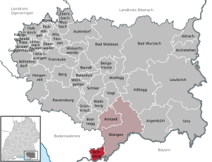
| Location of the municipality of Achberg in the Ravensburg district | ||
  |
||


The municipality of Achberg is located in the Argental on the Baden-Württemberg- Bavarian border in the south of the Ravensburg district . The community name goes back to Achberg Castle . There is an administrative community with the city of Wangen im Allgäu and the municipality of Amtzell .
geography
Community structure
The municipality of Achberg consists of the parish villages Esseratsweiler and Siberatsweiler as well as the hamlets Doberatsweiler, Pechtensweiler, Gunderatweiler, Liebenweiler, Baind, Bahlings, Isigatweiler, Regnitz and Duznau. There are also the residential areas Buflings, Englitz, Siggenreute, Storeute, Frauenreute and Rankenbühl. Another place to live is Achberg, consisting of the castle with the official building and domain.
Esseratsweiler and Siberatsweiler and the areas belonging to them belong as former parts of Hohenzollern under canon law to the Archdiocese of Freiburg, but have been looked after by the diocese Rottenburg-Stuttgart since 2007.
Protected areas
Within the municipal area, the three are currently protected areas " evil one ", " Hermann Weiher " and " Regnitzer pond " and the conservation area " Achberg " reported. (As of February 1, 2011)
history
Pechtensweiler is mentioned in a document as the first district in 839. Achberg is mentioned in documents for the first time in 1194. The lords of Achberg were vassals of the Counts of Veringen in 1197 and 1239 . The Lords of Achberg were followed by the Truchsessen von Waldburg (1235–1335) and the Lords of Molpertshaus (1335–1352). From 1352 the rule was an Austrian fiefdom , 1366-1392 the place was owned by the Öder family. In 1412 the Counts of Königsegg followed , and in 1530 the Barons of Syrgenstein . 1691 Achberg was sold to the Teutonic Order by Josef Franz Ferdinand von Syrgenstein . Until 1805 it was under the Altshausen Land Commandery of the Deutschordensballei Schwaben-Alsace-Burgundy .
In the course of secularization , Bavaria took possession of the Achberg rulership in December 1805 , but the 1806 Rhine Confederation Treaty gave the castle and rulership to the Principality of Hohenzollern-Sigmaringen . When the principality fell to Prussia in 1850 , Achberg, as the southernmost part of the Hohenzollern Lands, became the southernmost part of Prussia. During the German War , Achberg was briefly occupied by Bavarian troops in 1866 . From 1806 to 1854 the Obervogteiamt Achberg , congruent with the municipality, was its own Hohenzollern Oberamt . It then belonged to the Oberamt Sigmaringen , which in 1925 became the Sigmaringen district . On January 1, 1969, Achberg was awarded to the district of Wangen in the course of the district and community reform and joined the district of Ravensburg on January 1, 1973.
politics
mayor
Mayor is Johannes Aschauer (independent). He was re-elected for the second time in April 2013; Aschauer came with a turnout of 72.97% to 71.62 percent of the valid votes.
Municipal council
The municipal council election on May 25, 2014 brought the following result:
| list | Voting share | Seats | +/- |
| Citizen List | 58.3% | 5 | (−2) |
| Green open list | 26.6% | 3 | (± 0) |
| Achberg list | 8.6% | 1 | (+1) |
| Responsible citizens of Achberg | 6.5% | 1 | (+1) |
The turnout was 61.95%, which is 2.62 percentage points higher than in the 2009 local elections. The local council still consists of seven men and three women.
coat of arms
Description of the coat of arms : A black cross with paw ends in silver over a green three-mountain topped with a silver wavy strip .
The coat of arms and the flag colors black and white were awarded to the municipality on October 7, 1968. The black Teutonic Cross is a reminder of membership of the Teutonic Order, the mountain and the wavy bar make the coat of arms "talking" (Berg an der Ach).
Until 1968, the municipality had a coat of arms that showed an eight-pointed black star in gold over a green eight mountain. With this unusual coat of arms, the community name was misinterpreted as "Achtberg" in terms of folk etymology. The star probably had no other meaning and was used exclusively for decorative purposes.
Cultural monuments

The Achberg Castle is used today in the possession of the district Ravensburg and exhibitions from the rich art collection of the circle as well as for special exhibitions and concerts.
Sons and daughters of the church
- Franz Johann Vogt von Altensumerau and Prasberg (1611–1689), Prince-Bishop of Constance
- Fidelis Dehm OFM Conv. (1825-1883); Franciscan Terminorit , Titular Bishop of Colophon and Apostolic Visitator in Romania .
- Wolfgang Sander (* 1944), educator
See also
Web links
Individual evidence
- ↑ State Statistical Office Baden-Württemberg - Population by nationality and gender on December 31, 2018 (CSV file) ( help on this ).
- ↑ Jurisdiction agreement on the regulation of legal matters in diocesan exclaves between the Archbishop of Freiburg and the Bishop of Rottenburg-Stuttgart of December 5, 2006
- ^ Günther Bradler: Studies on the history of ministeriality in the Allgäu and in Upper Swabia. Göppingen 1973. p. 236.
- ^ State archive Sigmaringen: Authority and inventory history Obervogteiamt Achberg
- ↑ http://www.achberg.de/de/Rathaus/Wahlen
- ↑ Result of the election at the State Statistical Office of Baden-Württemberg ( memento from August 8, 2014 in the Internet Archive ) - accessed on August 8, 2014
- ↑ Heinz Bardua: District and community arms in Baden-Württemberg . Volume 4. ISBN 3-8062-0804-2 , p. 29

Achberg | Aichstetten | Aitrach | Altshausen | Amtzell | Argenbühl | Aulendorf | Bad Waldsee | Bad Wurzach | Baienfurt | Baindt | Mountain | Bergatreute | Bodnegg | Boms | Ebenweiler | Ebersbach-Musbach | Eichstegen | Meat cheeks | Fronreute | Green cabbage | Guggenhausen | Horgenzell | Hoßkirch | Isny im Allgäu | Kisslegg | Königseggwald | Leutkirch im Allgäu | Ravensburg | Riedhausen | Schlier | Unterwaldhausen | Vogt | Waldburg | Wangen im Allgäu | Vineyard | Wilhelmsdorf | Wolfegg | Wolpertswende