
Amtzell
| coat of arms | Germany map | |
|---|---|---|

|
Coordinates: 47 ° 42 ' N , 9 ° 45' E |
|
| Basic data | ||
| State : | Baden-Württemberg | |
| Administrative region : | Tübingen | |
| County : | Ravensburg | |
| Height : | 556 m above sea level NHN | |
| Area : | 30.57 km 2 | |
| Residents: | 4213 (December 31, 2018) | |
| Population density : | 138 inhabitants per km 2 | |
| Postal code : | 88279 | |
| Area code : | 07520 | |
| License plate : | RV, SLG , ÜB , WG | |
| Community key : | 08 4 36 006 | |
| LOCODE : | DE ATZ | |
| Address of the municipal administration: |
Waldburger Strasse 4 88279 Amtzell |
|
| Website : | ||
| Mayor : | Clemens Moll ( CDU ) | |
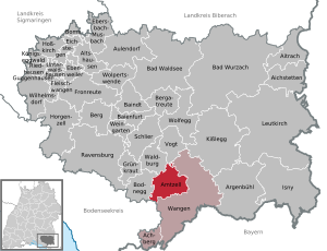
| Location of the municipality of Amtzell in the Ravensburg district | ||
  |
||

Amtzell is a community with 124 individual farmsteads and hamlets in Upper Swabia and is known as the "Western gateway to the Allgäu ". In a description of the Oberamt Wangen from 1841 it is stated that the community (at that time still Pfärrich) is "the most parceled out of the whole kingdom".
There is an administrative community with the city of Wangen im Allgäu and the municipality of Achberg .
geography
location
Amtzell is about halfway between the cities of Ravensburg and Wangen im Allgäu on federal highway 32 . It lies in a typical moraine landscape of the foothills of the Alps. In good weather conditions, the panorama of the Swiss and Vorarlberg alpine chains is perfectly visible. Hops are also grown in the lower parts of the municipality .
Neighboring communities
Neighboring communities are Bodnegg , Neukirch , Vogt , Waldburg and the city of Wangen im Allgäu.
Protected areas
Three nature reserves ( Ebersberger Weiher , Herzogenweiher , Krottental-Karbach ) and two landscape protection areas ( Karbachtal , young moraine landscape between Amtzell and Vogt ) are designated within the municipality . (As of April 1, 2010)
history


Until recently it was suspected that Amtzell was a foundation of the St. Gallen monastery , which is indicated by the part of the name -zell (derived from cella ). The inhabitants are often called Zeller in dialect . Feuds from this monastery in Pfärrich, Karbach and Schattbuch underpinned the thesis. The district of Karbach, for example, was first mentioned in a document from the St. Gallen monastery in 853. Recent research calls into question the St. Gallic ancestry. An ecclesia in Annencelle was mentioned for the first time in 1275 in a document from the Diocese of Constance .
In 1257 Heinrich von Ravensburg donated the place to the Weißenau monastery . In 1360 the court and the bailiff's rights were acquired. Then it passed into the possession of the von Hartnang family. In 1594 the Humpis von Waltrams ruled, in 1670 the lords von Altmannshausen and from 1749 the von Reichlin-Meldeggs over the town of Amtzell. The parcels of the current municipality belonged to many rulers, including the Weingarten Monastery , the Weißenau Monastery, the Altshausen Teutonic Order , the Truchsessen von Waldburg and some to Upper Austria . In 1806 Amtzell came to the Kingdom of Württemberg and was assigned to the Altdorf Oberamt as a separate municipality, but was added to the Wangen Oberamt as early as 1810 due to the dissolution of this Oberamt . In 1826 it was incorporated into Pfärrich. The municipal administration moved into the former castle in Amtzell in 1844, which meant that the municipality name also changed to Amtzell, which in turn led to animosity that lasted for decades. In 1938, several enclaves belonging to the then dissolved Eggenreute municipality were assigned to the municipality. During the administrative reform in 1973, the issue of ex- and enclaves was finally resolved. Until its dissolution on January 1, 1973, the community belonged to the district of Wangen .
The Second World War claimed many victims among the drafted soldiers (107 killed, 53 missing), but hardly among civilians. On July 19, 1944, a driverless aircraft of the Allies, presumably shot down in the bombing of Friedrichshafen, crashed into the Stahrenberg farm. Four people were killed. When French soldiers advanced on Wangen, resistance was offered in Geiselharz on April 29, 1945, which resulted in the settlement being bombarded and cremated.
See also Pfaffenweiler ruins .
Religions
There is a Roman Catholic and an Evangelical pastoral office in Amtzell .
politics
Municipal council
In Amtzell, the municipal council is elected using the spurious selection of a part of town. The number of local councils can change due to overhang mandates . The municipal council in Amtzell has 13 members after the last election (unchanged). The local elections on May 26, 2019 led to the following preliminary final result. The municipal council consists of the elected voluntary councilors and the mayor as chairman. The mayor is entitled to vote in the municipal council.
| Parties and constituencies | % 2019 |
Seats 2019 |
% 2014 |
Seats 2014 |
||
|---|---|---|---|---|---|---|
| CDU | Christian Democratic Union of Germany | 32.6 | 4th | 35.4 | 5 | |
| UL | Independent list of Amtzell-Pfärrich | 28.6 | 4th | 25.9 | 3 | |
| BAP | Citizens for Amtzell and Pfärrich | 20.8 | 3 | 21.4 | 3 | |
| SPD | Social Democratic Party of Germany | 9.1 | 1 | 17.2 | 2 | |
| OBL | Open Colorful List | 8.9 | 1 | - | - | |
| total | 100 | 13 | 100 | 13 | ||
| voter turnout | 70.2% | 59.7% | ||||
Mayor and mayor
The following mayors held office in the municipality of Pfärrich (until 1844) and then Amtzell (until 1933 " Schultheißen "):
- 1568–1599: Hans Huetter (from Winkelmühle)
- 1600–1601: Jerg Merlin (from Ruzenweiler)
- 1616–1632: Martin Weyhe (from Ibele)
- 1637–1652: Jakob Stüblin (from Pfärrich)
- 1652–1671: Gregorius Möhrlin (from Pfärrich)
- 1671–1687: Ludwig Phillipp Scherrich (from Pfärrich)
- 1687–1688: Georg Heinrich Mauch (from Pfärrich)
- 1688–1689: Michael Schedler (from Hankelmann)
- 1708–1735: Johann Jakob Schedler (from Unterhelbler)
- 1735–1752: Franz Anton Unold (from Karbach)
- 1752–1755: Peter Jocham (from Bremen)
- 1755–1767: Franz Anton Unold (from Karbach)
- 1767–1779: Johann Michael Renauer (from Schnabelau)
- 1779–1809: Johann Cornelius Unold (from Karbach)
- 1809–1811: Franz Xaver König (from Pfärrich)
- 1811–1837: Dominicus Pflegehar (from sphere)
- 1837–1840: Michael Wucher (from Oberhelbler)
- 1840–1844: Josef Wucher (from Büchel)
- 1844-1860: ?? Mayr (from Toblach / Tyrol)
- 1860–1876: Konrad Amann (from Schnabelau)
- 1876–1889: Josef Baptist König (from Pfärricherhöf)
- 1889–1913: Gallus Riedesser (from Neuravensburg )
- 1914–1933: Ludwig Steimle (from Pfullingen)
- 1933–1946: Julius Karle (from Buchau)
- 1946–1948: Josef Duller (from Geiselharz)
- 1948–1966: Gebhard Stilz (from Amtzell)
- 1966–1986: Walther Schmid (from Leutkirch)
- 1986–2010: Paul Locherer (from Burgrieden)
- since 2010: Clemens Moll (from Bad Saulgau)
coat of arms
The coat of arms, which has existed since 1938, shows a bear as a symbol for the (today rather controversial) former affiliation to the St. Gallen Monastery , the Montfort flag reminds of the rule of the Counts of Montfort , who had a strong influence over centuries with their residences in Tettnang, Bregenz and Feldkirch exercised.
Parish partnership

Amtzell has maintained a community partnership with the French community of Cosne-d'Allier in Auvergne since 1971 . In addition, there has been a friendship with Eichstetten am Kaiserstuhl in Baden-Württemberg since 1993 . The community maintains other friendly relationships with Oberlichtenau , part of the city of Pulsnitz in Saxony, and with the market town of Kammern im Liesingtal , Styria (Austria).
Culture and sights


Amtzell is located on Mühlenstraße Oberschwaben , which leads past many sights.
Buildings
The parish church of St. Johannes Evangelist & Mauritius , documented as early as 1250, is a late medieval basilica that was redesigned in Baroque style in 1758. The foundation walls of the tower are probably of Romanesque origin, as is the font. The church was renovated in 1972/73. During a further renovation in 1999, Clemens Hillebrand also designed the floor around the altar with stone inlays, which represent the four rivers of Paradise . The epitaph for Joachim von Sirgenstein († 1588) is well worth seeing .
Located east of Amtzell in Pfärrich is the parish church of the Birth of Mary, founded around 1350 as a chapel and consecrated as a pilgrimage church in 1386 . It is an early example of baroque wall pillar construction based on the Vorarlberg model.
Clubs and customs
Oldest clubs are the band was founded in 1764 Amtzell who in 1774 first mentioned Justinigrenadiere that today as vigilantes occur Amtzell and together with the founded in 1924, marching band at the fair, the Corpus Christi procession and together with the established in 1911 bloodriders group Amtzell on Weingartener Blutritt participate.
In 1996 the fool's guild Amtzeller Ramseweible eV was founded to maintain the customs , and in 2006 it was accepted into the Alemannic Fool's Ring (ANR). In addition, there has been the Narrenverein Schlossgoischter eV, which still exists today, since 1993
Regular events
- Fool's jump on "Bromigen Friday" (Friday before Carnival Sunday)
- The “fool's jump” has been held in Amtzell since the 1960s, when it was carried out by the “mosquito splashes”. Since 1997 the fool's guild Amtzeller Ramseweible eV has been organizing the parade with an average of 55 groups of rabbits and music bands from the area as well as from Vorarlberg and Switzerland.
- Easter market on the Saturday before Palm Sunday
- Justinifest on Whit Monday
- Mauritius Festival on the 3rd weekend in September
- Christmas market on the Saturday before the 1st Sunday in Advent
Economy and Infrastructure
traffic
The town of Amtzell is located on the federal highway 32 , which was moved from the town center to a bypass in 1998. The community u. a. connected with Ravensburg , Wangen im Allgäu and Isny and belongs to the Bodensee-Oberschwaben Verkehrsverbund (bodo) . Access to the motorway network is via the A 96 , which leads from Munich to Lindau (exit Wangen-West) . From Amtzell to Wangen there is a cycle path along the B 32.
education
With the rural school center in Amtzell there is a primary and a community school in the village .
Personalities
Honorary citizen
- 1954: Alfons Stübe, former pastor of Amtzell
- 2018: Walther Schmid, former mayor of Amtzell
Sons and daughters of the church
- Franz Anton Kiene (1777–1847), organ builder
- Reinhold Roth (* 1953), motorcycle racing driver, Vice World Champion 1987 and 1989
literature
- Ludwig Frisch: Municipality of Amtzell then and now . Self-published, Amtzell-Buchreute 1974.
- Georg Müller: Parish. History of a pilgrimage church . Working group for the history of the municipality of Amtzell, Amtzell 1991.
- Georg Müller: Amtzell. Castle and knighthood . Working group for the history of the municipality of Amtzell, Amtzell 1994.
- Walther Schmid (Ed.): Amtzell. Pictures from days gone by . Geiger, Horb 1986, ISBN 3-924932-90-5 .
Web links
Individual evidence
- ↑ State Statistical Office Baden-Württemberg - Population by nationality and gender on December 31, 2018 (CSV file) ( help on this ).
- ↑ Election information for the municipal data center

Achberg | Aichstetten | Aitrach | Altshausen | Amtzell | Argenbühl | Aulendorf | Bad Waldsee | Bad Wurzach | Baienfurt | Baindt | Mountain | Bergatreute | Bodnegg | Boms | Ebenweiler | Ebersbach-Musbach | Eichstegen | Meat cheeks | Fronreute | Green cabbage | Guggenhausen | Horgenzell | Hoßkirch | Isny im Allgäu | Kisslegg | Königseggwald | Leutkirch im Allgäu | Ravensburg | Riedhausen | Schlier | Unterwaldhausen | Vogt | Waldburg | Wangen im Allgäu | Vineyard | Wilhelmsdorf | Wolfegg | Wolpertswende