
Boms
| coat of arms | Germany map | |
|---|---|---|

|
Coordinates: 47 ° 58 ' N , 9 ° 31' E |
|
| Basic data | ||
| State : | Baden-Württemberg | |
| Administrative region : | Tübingen | |
| County : | Ravensburg | |
| Local government association: | Altshausen | |
| Height : | 638 m above sea level NHN | |
| Area : | 9.56 km 2 | |
| Residents: | 664 (Dec 31, 2018) | |
| Population density : | 69 inhabitants per km 2 | |
| Postal code : | 88361 | |
| Area code : | 07581 | |
| License plate : | RV, SLG , ÜB , WG | |
| Community key : | 08 4 36 019 | |
| LOCODE : | DE 42B | |
| Address of the municipal administration: |
Kirchstrasse 1 88361 Boms |
|
| Website : | ||
| Mayor : | Peter Wetzel | |
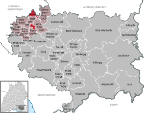
| Location of the municipality of Boms in the Ravensburg district | ||
  |
||


Boms is a municipality in the district of Ravensburg in Baden-Württemberg in Germany .
Since 1972 the community has been a member of the Altshausen community administration association based in Altshausen .
geography
location
Boms lies between Bad Saulgau and Altshausen on the main European watershed .
Neighboring communities
Boms borders on Bad Saulgau in the district of Sigmaringen and on Altshausen , Ebenweiler , Ebersbach-Musbach and Eichstegen in the district of Ravensburg .
structure
In addition to Boms, the villages of Hundsücken, Schwarzenbach and Glochen and, in an exclave, the villages of Litzelbach and Haggenmoos belong to the municipality. Ingenhart also belonged to the municipality (now to Altshausen) until 1833.
history
Until the 18th century
In today's municipality there were two Roman manors near Glochen and in the Apsenwald.
The suburb of Schwarzenbach was first mentioned in 1128 as Suerzebach . Local nobility is documented from 1127 to 1311. Ulrich, Ritter von Schwarzenbach , a ministerial of the Counts of Nellenburg, called himself Hundsrukke in 1230 after what is now Hundsücken .
Boms was first mentioned as Bams in 1275 , then in 1353 under the current name of Boms . The origin of the name is unclear, a derivation of bameze = tree material is suspected. Boms and its surroundings were divided into numerous small parcels and rulership areas, including areas belonging to Friedberg-Scheer , the Upper Austrian Bailiwick of Swabia , the area of the Lords of Königsegg , the Kommende Altshausen of the Teutonic Order Swabia-Alsace-Burgundy and the monasteries Weingarten and Schussenried . From 1414 to 1683, Boms gradually came almost entirely into the possession of the Altshausen Teutonic Order through purchases. Until it was pledged to the Teutonic Order in 1759, the authority in the front of Austria, Geigelbach, held the sovereign rights.
19th and 20th centuries
In the course of secularization , the area of the Kommende Altshausen first became part of the Kingdom of Bavaria in 1806 , then part of the Kingdom of Württemberg in 1810 , where it had been part of the Saulgau District Office since 1813 .
On July 25, 1869, the Hochberg station on the Herbertingen – Isny railway line was opened near Boms , and its operations were later discontinued.
Until 1972 Boms belonged to the district of Saulgau , after its dissolution the municipality became part of the district of Ravensburg on January 1, 1973.
Population development
- 1829: 370 inhabitants
- 1900: 458 inhabitants
- 1961: 460 inhabitants
- 1969: 466 inhabitants
- 1970: 455 inhabitants
- 1991: 490 inhabitants
- 1995: 498 inhabitants
- 2005: 578 inhabitants
- 2010: 619 inhabitants
- 2015: 627 inhabitants
Religions
Around 400 Catholics currently live in Boms, who belong to the Catholic parish of the Assumption of Mary in Boms (Saulgau deanery). The Evangelical Lutheran believers belong to the Protestant parish Altshausen.
mayor
In November 2016, Peter Wetzel was re-elected with 86% of the vote.
Municipal council
After the 2014 election, the municipal council has eight members, seven men and one woman.
Culture and sights
Buildings
- Parish Church of the Assumption of Mary : A church of St. Urban in Boms was first mentioned in a document in 1275, and in 1361 it was donated to Habsthal Abbey by caste governor Hartuid Kröwel . Since 1558 the place was looked after by the St. Katharinen Chaplaincy in [Saulgau]. In 1728 the Habsthal Abbey sold the patronage and ownership rights to the Altshausen Teutonic Order. It was not until 1869 that Boms was raised to an independent parish. In 1882 the church was rebuilt and consecrated to Our Lady of La Salette . Today it bears the title "Assumption of Mary". A La Salette chapel is located in the Schwarzenbach district.
- Village community center from 1998
- Village fountain by Dagmar Geiger
Economy and Infrastructure
With around 400 hectares of arable land and 350 hectares of permanent grassland, Boms is characterized by agriculture , and there are 162 hectares of private forest. Many residents commute to Bad Saulgau and Altshausen.
traffic

Boms is connected to Bad Saulgau, Altshausen, Aulendorf and Ravensburg by bus lines . The community belongs to the Bodensee-Oberschwaben transport association ( bodo ).
Boms is located on the federal highway 32 between Bad Saulgau and Altshausen, around six kilometers south of Bad Saulgau.
education
There is no school in Boms, elementary school students attend the elementary school in Altshausen. There is a kindergarten in the community.
literature
- Chronicle of the Ravensburg district. Landscape, history, customs, art . Chroniken-Verlag Boxberg, Hinterzarten 1975
- Oskar Sailer (ed.): The district of Ravensburg . Theiss, Stuttgart 1976 ISBN 3-8062-0145-5
- Johann Daniel Georg von Memminger: Description of the Oberamt Saulgau . New edition. Unchangeable photomechan. Reprint [d. Edition] Stuttgart u. Tübingen, Cotta, 1829. Reprint Magstadt (near Stuttgart): Horst Bissinger KG Verlag und Druckerei, 1982. (Descriptions of the Württemberg authorities, vol. 6). ISBN 3-7644-0006-4 ( full text on Wikisource )
Web links
Individual evidence
- ↑ State Statistical Office Baden-Württemberg - Population by nationality and gender on December 31, 2018 (CSV file) ( help on this ).
- ↑ http://www.boms.de/de/rathaus/gemeinderat/

Achberg | Aichstetten | Aitrach | Altshausen | Amtzell | Argenbühl | Aulendorf | Bad Waldsee | Bad Wurzach | Baienfurt | Baindt | Mountain | Bergatreute | Bodnegg | Boms | Ebenweiler | Ebersbach-Musbach | Eichstegen | Meat cheeks | Fronreute | Green cabbage | Guggenhausen | Horgenzell | Hoßkirch | Isny im Allgäu | Kisslegg | Königseggwald | Leutkirch im Allgäu | Ravensburg | Riedhausen | Schlier | Unterwaldhausen | Vogt | Waldburg | Wangen im Allgäu | Vineyard | Wilhelmsdorf | Wolfegg | Wolpertswende