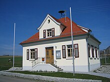
Guggenhausen
| coat of arms | Germany map | |
|---|---|---|

|
Coordinates: 47 ° 54 ' N , 9 ° 27' E |
|
| Basic data | ||
| State : | Baden-Württemberg | |
| Administrative region : | Tübingen | |
| County : | Ravensburg | |
| Local government association: | Altshausen | |
| Height : | 637 m above sea level NHN | |
| Area : | 8.25 km 2 | |
| Residents: | 189 (December 31, 2018) | |
| Population density : | 23 inhabitants per km 2 | |
| Postcodes : | 88379, 88373 | |
| Area code : | 07503 | |
| License plate : | RV, SLG , ÜB , WG | |
| Community key : | 08 4 36 040 | |
| Address of the municipal administration: |
Hauptstrasse 6 88379 Guggenhausen |
|
| Website : | ||
| Mayor : | Jochen Currle | |
| Location of the community of Guggenhausen in the Ravensburg district | ||
Guggenhausen is the smallest municipality in the Ravensburg district in Baden-Württemberg . The community is a member of the Altshausen community administration association based in Altshausen .
Community structure
In addition to Guggenhausen (with around 20 houses including the town hall), the hamlets and courtyards Bauhof, Brunnen, Egg, Haslach, Königsegg, Luegen, Muttenhaus and Wendenreute belong to the municipality.
history
Celtic burial mounds have been identified in the hamlets of Brunnen and Egg .
Guggenhausen was first mentioned in a document as Guginhusin in 1251 , the name probably goes back to the personal name Gucko . For the year 1264 donations from the treasurer Heinrich von Bigenburg of possession in the place to the monastery of Baindt are documented.
The Königsegg Castle was the ancestral castle of a branch of the Lords of Fronhofen , who called themselves Lords of Königsegg from 1251 , came into the possession of the whole place in the 14th century and in the course of time larger areas in the area and near Aulendorf and between Oberstaufen and Immenstadt acquired. In the middle of the 17th century they moved their residence to Königseggwald , their county fell in 1806 to the Kingdom of Württemberg , which assigned it to the Saulgau District Office. The ancestral castle in Königsegg was converted into an estate in the 19th century, a castle chapel in the east wing with a renaissance holy water font was preserved. Königsegg Castle was part of the municipality of Hoßkirch until 1850 and has since been an exclave of Guggenhausen with its eastern surroundings .
Until 1972 Guggenhausen belonged to the Saulgau district . With its dissolution, the community became part of the Ravensburg district on January 1, 1973.
Population development
- 1825: 186 inhabitants
- 1900: 200 inhabitants
- 1961: 199 inhabitants
- 1970: 196 inhabitants
- 1974: 196 inhabitants
- 1991: 202 inhabitants
- 1995: 216 inhabitants
- 2005: 200 inhabitants
- 2010: 181 inhabitants
- 2015: 179 inhabitants
politics
mayor
Erich Köberle was confirmed as honorary mayor on November 9, 2008 with 84.8 percent of the votes cast; there was no opposing candidate. Köberle has been running the community since 1993; He works full-time at the Biberach district office.
coat of arms
The municipal coat of arms, awarded on August 26, 1980, reminds of the coat of arms of the Counts of Königsegg-Aulendorf with its red and gold diamonds . The blue base of the shield symbolizes the Guggenhauser Weiher with its waves.
Blazon : Above a blue corrugated shield base of gold (yellow) and red with three divisions roughened diagonally.
Economy and Infrastructure
Guggenhausen is shaped by agriculture . Almost half of the municipal area is arable land, another 195 hectares are permanent grassland; there are also around 70 hectares of forest area.
The Guggenhauser Weiher , where a grinding and sawmill was operated, was created around 1840 . The pond, which has a water surface of 10.1 hectares, is used by sport fishermen today.
traffic
Guggenhausen is connected to Wilhelmsdorf , Ostrach , Altshausen and Bad Saulgau by bus lines . The community is part of the Bodensee-Oberschwaben transport association ( bodo ). Until 1971, the Königsegg district had a train station on the Altshausen – Schwackenreute railway line .
Individual evidence
- ↑ State Statistical Office Baden-Württemberg - Population by nationality and gender on December 31, 2018 (CSV file) ( help on this ).
literature
- Chronicle of the Ravensburg district. Landscape, history, customs, art . Chroniken-Verlag Boxberg, Hinterzarten 1975.
- Oskar Sailer (ed.): The district of Ravensburg . Theiss, Stuttgart 1976, ISBN 3-8062-0145-5


