Schnaitkapf
| Schnaitkapf | ||
|---|---|---|
|
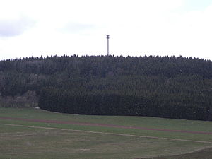
View from Kreisstraße 8213 to the Schnaitkapf |
||
| height | 920.3 m above sea level NN | |
| location | Baden-Württemberg | |
| Mountains | Swabian Alb | |
| Coordinates | 48 ° 6 '3 " N , 8 ° 57' 54" E | |
|
|
||
| particularities | Highest elevation in the district of Sigmaringen | |
The Schnaitkapf (also Schnaitkopf ) is 920.3 m above sea level. NHN the highest elevation in the Sigmaringen district in Baden-Württemberg .
Location and surroundings
The mountain is located west of Schwenningen on the Heuberg and thus belongs to the Swabian Alb . On the summit of the Schnaitkapf there is a transmission tower, at the foot of which is the Wilhelmshütte, a shelter built in 1939 with a barbecue area.
height
The highest elevation in the Sigmaringen district is the Schnaitkapf in the north near Schwenningen at 920.3 m above sea level. NHN , the highest mountain that does not belong to the Swabian Alb, is 833 meters above sea level. NN the highest in the south.
Individual evidence
- ^ Schwenningen in the local lexicon of the Baden-Württemberg State Archives
- ↑ Map services of the Federal Agency for Nature Conservation ( information )
- ↑ Chronology of the Schwenningen community in key words ( memento of the original from October 16, 2011 in the Internet Archive ) Info: The archive link has been inserted automatically and has not yet been checked. Please check the original and archive link according to the instructions and then remove this notice. ; Retrieved December 14, 2011

