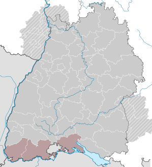
Hochrhein-Bodensee region
| logo | map |
|---|---|

|
|
| Basic data | |
| State : | Baden-Württemberg |
| Administrative region : | Freiburg |
| Administrative headquarters : | Waldshut-Tiengen |
| Area : | 2,755.88 km² |
| Residents : | 684,583 (December 31, 2018) |
| Population density : | 248 inhabitants / km² |
| Regional breakdown: | 3 counties |
| Regional association | |
| Association chairman: | Marion Dammann |
| Association Director: | Karl Heinz Hoffmann-Bohner |
| Address of the regional association: | Im Wallgraben 50 79761 Waldshut-Tiengen |
| Website : | www.hochrhein-bodensee.de/ |
| map | |

|
|
The Hochrhein-Bodensee region is one of twelve spatial planning and planning regions in Baden-Württemberg . It includes the district of Lörrach , the district of Waldshut and the district of Konstanz .
Regional planning
The regional association Hochrhein-Bodensee was set up as a public corporation on January 1, 1973 as the body responsible for regional planning in the region . It is one of twelve regional associations in Baden-Württemberg , two of which are also responsible beyond state borders. The association assembly of the regional association Hochrhein-Bodensee was constituted for the first time on November 22, 1973. The office of the regional association is located in Waldshut-Tiengen .
Population development
The population figures are census results (¹) or official updates from the Baden-Württemberg State Statistical Office ( main residences only ).
|
|
|
Spatial planning
In the Hochrhein-Bodensee region there are the regional centers of Constance and (as a dual center) Lörrach / Weil am Rhein . The following middle areas exist , the delimitation of which can be found in the articles on the respective cities:
- Bad Säckingen
- Constancy
- Loerrach / Weil
- Radolfzell
- Rheinfelden
- Schopfheim
- To sing
- Stockach
- Waldshut-Tiengen
The border between the central areas of Lörrach / Weil and Müllheim ( southern Upper Rhine region ) in the area of the municipalities of Bad Bellingen and Schliengen was left open.
Division of space

According to data from the State Statistical Office , as of 2015.
Association chairperson
- 1973–1980: Werner Dierks
- 1980–2009: Bernhard Wütz ( former district administrator of the Waldshut district)
- 2009–2014: Tilman Bollacher , District Administrator
- since 2014: Marion Dammann , district administrator of the Lörrach district
Association directors
- 1973–1989: Theo Zengerling
- 1989–2003: Franz Schwendemann
- since 2003: Karl Heinz Hoffmann-Bohner
Web links
Individual evidence
- ↑ State Statistical Office Baden-Württemberg - Population by nationality and gender on December 31, 2018 (CSV file) ( help on this ).
- ↑ Survey of land according to type of actual use in 2015

