Oberbueren
| Oberbueren | |
|---|---|
| State : |
|
| Canton : |
|
| Constituency : | Wil |
| BFS no. : | 3424 |
| Postal code : | 9245 |
| Coordinates : | 730 316 / 256903 |
| Height : | 500 m above sea level M. |
| Height range : | 479–662 m above sea level M. |
| Area : | 17.73 km² |
| Residents: | 4448 (December 31, 2018) |
| Population density : | 251 inhabitants per km² |
| Website: | www.oberbueren.ch |
| Location of the municipality | |
Oberbüren is a municipality in the Fürstenland ( constituency of Wil ), canton of St. Gallen , Switzerland .
geography

With the villages of Oberbüren (2116 E.), Niederwil (1297 E.) and Sonnental (522 E.) and the hamlet of Staubhusen, the municipality is located at the confluence of the Glatt and the Thur . It is crossed by the A1 Geneva - St. Margrethen motorway and accessed via the Uzwil – Oberbüren exit; the Hauptstrasse 7 passes through Oberbüren.
The highest point in the municipality is the Schentis near Sidenberg in the Niederwil part of the municipality ( 660 m above sea level ). The lowest point is 484 m above sea level. M. an der Thur, on the border with the municipality of Niederbüren.
Oberbüren is surrounded by seven neighboring communities, namely Zuzwil SG , Niederhelfenschwil , Niederbüren , Gossau SG , Flawil , Oberuzwil and Uzwil .
history
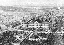
To the northeast of the Glatt estuary over a steep slope on the Thur is the Benedictine Abbey of St. Gallenberg , also popularly known as Glattburg Monastery . Traces of early Celtic settlements from the Bronze Age (approx. 1000 BC) were found here. Coin finds near Sonnental and on the Glattburg as well as a treasure find in Hörbimoos near Ufhofen are evidence of the Roman era. Traditional documents from the St. Gallen monastery mention Gebertschwil 745 as chiperativilare for the first time , Glattburg 788 as clataburuhc and Oberbüren 817 as purias . Today's community was created when the canton of St. Gallen was founded in 1803 from the parishes of Oberbüren and Niederwil and the village of Durstudlen, which belonged to the parish of Henau. Durstudlen, later Thurstuden, was renamed Sonnental in 1880 .
From 1843 the cold water sanatorium Bad Buchenthal existed in the municipality on the Glatt . It was under the direction of spa doctors and attracted guests from far and wide. A fire in 1907 put an end to the bathroom. In 1904, the Thur Bridge, designed by Robert Maillart , was built near Billwil . In 1958/1959 August Fust opened a company in Oberbüren that dealt with household goods, from which the later Dipl. Ing. Fust emerged .
In 2007, Oberbüren was the scene of the kidnapping of Ylenia Lenhard .
Attractions
literature
- Markus Kaiser: Oberbüren (SG). In: Historical Lexicon of Switzerland .
- Josef Grünenfelder: Benedictine Abbey St. Gallenberg Glattbrugg, Oberbüren. (Swiss Art Guide, Volume 714). Ed. Society for Swiss Art History GSK. Bern 2002, ISBN 3-85782-714-9 .
Web links
Individual evidence
- ↑ Permanent and non-permanent resident population by year, canton, district, municipality, population type and gender (permanent resident population). In: bfs. admin.ch . Federal Statistical Office (FSO), August 31, 2019, accessed on December 22, 2019 .
- ↑ StiASG , Urk. I 2. Online at e-chartae , accessed on June 25, 2020.
- ↑ StiASG , Urk. I 101. Online at e-chartae , accessed on June 25, 2020.
- ↑ StiASG , Urk. II 26. Online at e-chartae , accessed on June 25, 2020.


