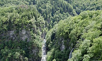
Rovana
|
Rovana Rovana di Campo |
||
|
The Rovana |
||
| Data | ||
| Water code | CH : 4915 | |
| location | Italy | |
| River system | Po | |
| Drain over | Maggia → Ticino → Po → Adria | |
| origin | Confluence of Rio Colobiasca and Rio della Stuffa 46 ° 16 '22 " N , 8 ° 26' 46" O |
|
| Source height | approx. 1415 m slm | |
| muzzle | at Cevio in the Maggia coordinates: 46 ° 18 ′ 30 ″ N , 8 ° 36 ′ 36 ″ E ; CH1903: 690 225 / 129211 46 ° 18 '30 " N , 8 ° 36' 36" O |
|
| Mouth height | 401 m above sea level M. | |
| Height difference | approx. 1014 m | |
| Bottom slope | approx. 52 ‰ | |
| length | 19.4 km | |
| Catchment area | 110.7 km² | |
| Left tributaries | Rovana di Bosco | |
| Communities | Campo , Cerentino , Linescio , Cevio | |
The Rovana (also Rovana di Campo) is a 19.4 km long right tributary of the Maggia , which arises in Italy and runs mainly on Swiss territory. It drains the Valle di Campo and its side valleys, including the Valle di Bosco , which is drained by its main tributary, the Rovana di Bosco . Along with the Bavona and the Melezza, it is the most important tributary of the Maggia.
course
The Rovana is created by the confluence of the Rio Colobiasca and Rio della Stuffa at about 1415 m slm directly on the border. The Rio Colobiasca rises on Pizzo dei Croselli at about 2420 m slm and the Rio della Stuffa on Pizzo Quadro at about 2467 m slm
It now flows together in a north-easterly direction through the Valle di Campo and tangent to Campo and Niva . At Collinasca it takes up the Rovana di Bosco, passes Linescio and after a further 7 kilometers it flows into the Maggia opposite Visletto .
In the upper reaches of the Rovana there is a geological slide and creep area, which affects the places Campo and Cimalmotto .
history
Since 1780 there has been documentation of landslide activity in the area of Campo. In 1818 the river bed was still 30 m below Campo. In 1851 there were 506 inhabitants in Campo. The intensive logging that then began destroyed the river bed. In 1858 all the houses in Campo were torn apart and in 1859 rafting was finally banned. In 1867/68 a rock fall on the right bank forced the river to the endangered left side of the valley. Severe bank erosion and demolitions were the result.
In 1892 the Rovana had deepened over 105 m. Around 1900 there were 291 inhabitants in Campo, in 1970 only 102. Subsequent landslides and floods in 1987 with effects as far as Locarno reduced the population to 59 in 1990.
Modern
In 1993/94 renovation measures began with drainage tunnels, diversion tunnels, surface water drainage, slope foot protection and relocation of the rovana bed on the right side of the valley. A 1800 m long diversion tunnel of the Rovana alone cost 20 million CHF.
According to a report from 2002, 90 million Swiss francs were invested in constructions because if the high plateau of Campo slid down, the valley could become clogged and the whole Ascona Delta threatened.
Web links
- Rovana on the ETHorama platform
Individual evidence
- ↑ a b c individual records on the geoserver of the Swiss federal administration
- ↑ Hydrological Atlas of Switzerland of the Federal Office for the Environment FOEN, Table_13
- ↑ a b c d J. Zeller and F. Tognini The Rovana in the canton of Ticino: Small cause big effect Interpraevent 1996, Volume 2, pp. 169–179
- ↑ Flood - diversion tunnel of the Rovana IM Maggia Engineering AG, undated
- ^ Villages on the way into the abyss Neue Zürcher Zeitung, August 18, 2002
