Tambogroup
| Tambogroup | |
|---|---|
|
Group on the south-eastern edge of the Western Alps |
|
|
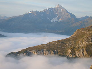
The Tambohorn beyond the Hinterrhein Valley. |
|
| Highest peak | Tambohorn ( 3279 m above sea level ) |
| location | Switzerland / Italy border area |
| part of | Western alps |
| Coordinates | 733 751 / 114856 |
| surface | 2,600 km² |
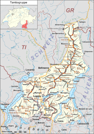
The Tambogruppe is a mountain group in the border area between Switzerland and Italy . It is located in the southeast of the Western Alps and extends to the cantons of Graubünden and Ticino , as well as the Lombard provinces of Varese , Como and Sondrio .
Location & area
The area is bounded (clockwise from the north) by the Hinterrhein , Hüscherenbach , Splügenpass , Liro , Mera , eastern arm of Lake Como , the Po plain , Lake Maggiore , Ticino , Moësa and the San Bernardino Pass and covers an area of 2600 km 2 .
If the group is limited by two large northern Italian lakes , Lake Lugano is in between. From here a long, uninterrupted chain stretches northwards, which always forms the border between Switzerland in the west and Italy in the east, to the eponymous Pizzo Tambo , where, together with the main Alpine ridge, it turns towards the Splügen Pass . It is, so to speak, the central point of the Alps, because on this saddle the north-south running west-east Alps border and the west-east running ridge line between the north and south Alps intersect. This is an early historical transition.
The north-south expansion of the group is considerable, as it extends from the Rhine forest north of the main Alpine ridge ( watershed ) to the Po Valley .
Groups & summits
The tambo group is divided into the following seven subgroups:
- Tambo-Curciusa-Group with the Pizzo Tambo (Tambohorn) 3279 m above sea level. M.
- Piz Pombi chain with the Piz Corbet 3,025 m above sea level. M.
- Pizzo-Paglia-Gruppe with the Pizzo-Paglia 2593 m above sea level. M.
- Camogè-Támaro group with the Monte Tamaro 1960 m above sea level. M.
- Varese foothills with the Monte Campo dei Fiori 1227 m above sea level. M.
- Generoso-Intelvi Group with Monte Generoso 1701 m above sea level. M.
- Alta Brianza with Monte San Primo 1682 m above sea level. M.
Valleys & places
The dividing valleys are relatively short throughout, so there are only a few places in the interior of the mountain range, such as Lugano and Porlezza ; on its edge are Splügen , Lecco , Como , Varese , Luino and Bellinzona . Its lowest point is on the shores of Lake Maggiore at 193 m slm , which is a difference to the highest of 3086 m.
Web links
Evidence & Notes
- ^ A b Ernst Höhne: Knaur's Lexicon for Mountain Friends / The Alps between Matterhorn and Lake Constance . Droemer Knaur, Munich 1987, ISBN 3-426-26223-1 , p. 272 ff .
- ↑ a b Assigned to the Adula Alps according to SOIUSA & Swiss Alpine Club (SAC) .
- ^ Assigned to the Glarus Alps according to SOIUSA & SAC .
- ↑ a b According to SOIUSA & SAC assigned to the Vares Prealps (SOIUSA) as part of the Lugano Prealps (SOIUSA) .
- ↑ a b Assigned to the Comer Prealps (SOIUSA) according to SOIUSA & SAC .

