
Hüscherabach
| Hüscherabach | ||
 The Hüscherabach in front of the confluence with the Hinterrhein. In the background the village of Splügen. |
||
| Data | ||
| Water code | CH : | |
| location | Canton of Graubünden ; Switzerland | |
| River system | Rhine | |
| Drain over | Hinterrhein → Rhine | |
| source | Splügenpass 46 ° 30 ′ 40 ″ N , 9 ° 19 ′ 5 ″ E |
|
| Source height | approx. 2370 m above sea level M. [1] | |
| muzzle | in the Hinterrhein Coordinates: 46 ° 33 ′ 7 ″ N , 9 ° 19 ′ 16 ″ E ; CH1903: 744 364 / 157358 46 ° 33 '7 " N , 9 ° 19' 16" O |
|
| Mouth height | 1451 m above sea level M. | |
| Height difference | approx. 919 m | |
| Bottom slope | approx. 15% | |
| length | approx. 6 km | |
| Communities | Rheinwald | |
The Hüscherabach (also Hüscherenbach ) is a brook in the Swiss canton of Graubünden . It has a length of about 6 kilometers.
Surname
The name of the stream is derived from the locality name Bi da Hüschera ( Walser German for “ near the houses”), a group of houses that is opposite the village of Splügen in the area of today's valley station of the mountain railway and next to which the stream flows before it enters the Hinterrhein flows out.
course
The Hüscherabach is formed from numerous nameless side streams that flow together in a wide basin on the north side of the Splügen Pass. Among other things, it also absorbs the water from the Bergseelis above the top of the pass. At an altitude of 1846 m above sea level. M. , below the serpentines of the pass road, the actual stream has formed from it. It flows north and after about one kilometer it passes the Isabrüggli, where the hiking trail to the Suretta lakes begins at the bus stop . After about another kilometer, it crosses under the marble bridge , after a steep bottleneck, crosses the road again and flows into the Hinterrhein in the village of Splügen.

Upper course in the valley basin on the north side of the Splügen Pass

Inflow from the east

At the Isabrüggli car park

Marble bridge
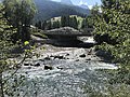
Confluence with the Hinterrhein


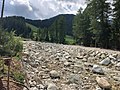
Flooding in summer 2019
On June 12, 2019, heavy rainfall fell on the north side of the Splügen Pass. The water collected in the valley basin, flowed through the funnel of the bottleneck above the village, whereby the gradient increased the pressure of the strongly swollen brook. At the exit of the ravine, the creek tore half of the parking lot and a VW bus parked there with it. The two men who had stayed there were rescued just in time. Then the brook damaged the road bridge, washed away the abutments and tore part of the road with it. Then it flooded the small forest to the left and right of the stream and tore numerous trees and the wooden footbridge with it. The A 13 motorway was also flooded, but not further damaged.

September 2013

Wooden bridge, September 2013
The same place in August 2019
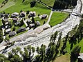
On the right the makeshift bridge, on the right the remains of the road bridge


Web links
Individual evidence
- ^ Rätisches Namenbuch , Volume 2: Etymologies. Edited and edited by Andrea Schorta. Bern 1964, p. 426 f.
- ↑ Wanderland.ch
- ↑ www.tagblatt.ch
- ↑ grheute.ch