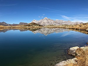
Upper Suretta Lake
| Upper Suretta Lake | ||
|---|---|---|

|
||
| Facing south. To the right of the middle above the bank is the Seehütte. In the background the Teurihorn . | ||
| Geographical location | Municipality of Splügen GR , Canton of Graubünden , Switzerland | |
| Drain | Strahlentobelbach | |
| Location close to the shore | Splügen GR | |
| Data | ||
| Coordinates | 746 842 / 155830 | |
|
|
||
| Altitude above sea level | 2266 m above sea level M. | |
| surface | 5.6 ha | |
| length | 330 m | |
| width | 150 m | |
The Ober Surettasee is a mountain lake southeast above the village of Splügen in the canton of Graubünden .
The name is derived from Rhaeto-Romanic sur , the Rhaeto-Romanic name of the village of Sufers , to which the area around the Suretta lakes once belonged. The lake used to be called "Rietboden Bergsee".
The lake is located east of the Räzünscher Alps at an altitude of 2266 m above sea level. M. in the area of the municipality of Splügen. The lake is located on the western flank of the Seehorn ( 2762 m above sea level ). Three kilometers south, which rises Surettahorn ( 3026 m above sea level. M. ).
The unattended lake hut is located on the northern shore of the lake. In summer there is a small three-seater rowing boat organized by the Viamala Tourist Office, which can be used free of charge. A few meters to the south is the small Turrasee, whose water flows through a small pond into the Upper Surettasee.
70 meters west below the Upper Surettasee is the somewhat smaller Under Surettasee (altitude: 2192 m above sea level ). The two lakes are connected by the 260 meter long Strahlentobelbach, which flows almost invisibly down between rocks. In the further course the brook flows into the Vorderrhein below Splügen .
The Surettaseen can be reached from Splügen in a steep ascent through the Fugschtwald; the difference in altitude is almost 800 meters. The easier route takes about 1.5 hours from the car park and the «Isabrüggli» post bus station on the road to the Splügen Pass, diagonally up to Under Surettasee. The difference in altitude is 500 meters here.
A few years ago, brook and arctic char were used in all three lakes . However, their population has degenerated so that hardly any fish over 20 cm in length are caught. Fishing is only allowed for residents of the municipality of Splügen and holiday guests with day tickets.
Under Lake Suretta looking west. Links of Pizzo Tambo , the right of Guggernüll
Web links
Individual evidence
- ↑ Andrea Schorta: How the mountain got its name . Terra Grischuna Verlag, Chur and Bottmingen / Basel 1988, ISBN 3-7298-1047-2 , p. 137 .
- ^ Charles Knapp, Maurice Borel, Victor Attinger, Heinrich Brunner, Société neuchâteloise de geographie (editor): Geographical Lexicon of Switzerland . Volume 4: Plessur - Switzerland . Verlag Gebrüder Attinger, Neuenburg 1906, p. 187, keyword Rietboden Bergseen ( scan of the lexicon page ).
- ↑ schweizersee.ch
- ↑ postauto.ch
- ↑ flyfisherbeat.com


