
Suretta maple
| Suretta maple | ||
|---|---|---|
 Suretta maple from the northwest |
||
| height | 3026 m above sea level M. | |
| location | Border canton Graubünden , Switzerland / Province Sondrio , Italy | |
| Mountains | Oberhalbsteiner Alps | |
| Dominance | 5.8 km → Piz Timun | |
| Notch height | 745 m ↓ Pass da Niemet | |
| Coordinates , ( CH ) | 46 ° 30 '34 " N , 9 ° 21' 44" O ( 747 635 / 152 721 ) | |
|
||
| First ascent | Arnold Baltzer with Georg Trepp, July 18, 1869 | |
.jpg) Steinmann on the suretta maple |
||

The Surettahorn ( derived from the village name Sufers , Rhaeto-Romanic Sur with -etta , meaning ‹Suferser Alp›) is a mountain with double peaks east of the Splügen Pass on the border between the Swiss canton of Graubünden and the Italian province of Sondrio at an altitude of 3,026 m above sea level. M. The western, slightly higher summit at 3026 m is Punta Nera ( Italian named for <black lace>); the eastern 3021 m high peak Punta Rossa (Italian for “red tip”, although the peak is strikingly yellow). The transition from one peak to the other is a bit airy, with favorable conditions WS , ¼ hour. A third, less prominent point in the southeast ridge is called Punta Adami ( 2978 m ).
Location and surroundings
The Surettahorn is the namesake of the Suretta Group, a subgroup of the Oberhalbsteiner Alps . The municipal boundaries of Sufers and Splügen in the canton of Graubünden , Switzerland , and the national border with the Italian province of Sondrio meet at the summit .
The neighboring peaks include the Piz Por in the east, the Piz Ursaregls in the southeast and the Inner Schwarzhorn , Mittler Schwarzhorn and the Outer Schwarzhorns in the west.
The farthest visible point ( 44 ° 4 '49.8' N , 7 ° 25 '56.2 " O ) is from Surettahorn 500 meters east of Grand Capelet in the French region Alpes-Côte d'Azur ( 44 km north-northeast of Nice ) and is 309 km away.
The surretta maple has a glacier on the north flank, on the east flank and on the south flank. Only the glacier on the south side is listed on the national map with the name Ghiacciaio di Suretta .
Valley locations are Monte Spluga, Splügen and Sufers . Frequent starting points are the Splügen Pass and the Alpi di Suretta.
South is the Surettahorn to 2753 m of Bivacco Suretta , a refuge of CAI .
Routes to the summit
Summer routes
Over the north ridge
- Starting point: Splügen Pass ( 2114 m ), Bodmenstafel on Splügenstrasse ( 1768 m ), Sufner Schmelzi ( 1340 m ) or Innerferrera ( 1480 m )
- Via: Surettajoch ( 2858 m )
- Difficulty: WS – ZS (when the snow has melted, climbing II )
- Time required: 3½ hours from the Splügen Pass, 4¼ hours from Bodmenstafel, 5½ hours from Sufner Schmelzi or 5½ hours from Innerferrera
Over the northeast ridge
- Starting point: Sufner Schmelzi ( 1340 m )
- Via: Punta Rossa
- Difficulty: WS
- Time required: 5 ¼ hours
Over the Suretta glacier

- Starting point: Innerferrera ( 1480 m )
- Via: Bocchetta de Pinerocolo
- Difficulty: WS
- Time required: 5 ¼ hours
Over the southeast ridge
- Starting point: Innerferrera ( 1480 m ) or Lago di Montespluga ( 1905 m )
- Via: Pass da Suretta ( 2580 m )
- Difficulty: L
- Time required: 5½ hours from Innerferrera or 3½ hours from Lake Montespluga (1½ hours from Pass da Suretta)
Through the southern flank

- Starting point: Splügenpass ( 2114 m ) or Lago di Montespluga ( 1905 m )
- Via: Bivacco Suretta
- Difficulty: L
- Time required: 3 ½ hours from the Splügen Pass or 3 ¼ hours from Lago di Montespluga (1 hour from Bivacco Suretta)
Through the western snow couloir
- Starting point: Splügenpass ( 2114 m ) or Lago di Montespluga ( 1905 m )
- Via: Bivacco Suretta
- Difficulty: L
- Time required: 3 ½ hours from the Splügen Pass or 3 ¼ hours from Lago di Montespluga (1 hour from Bivacco Suretta)
Through the southern flank of the Inner Schwarzhorn
- Starting point: Splügenpass ( 2114 m )
- Difficulty: L
- Time required: 3 ¼ hours
Winter routes
From Splügen
Direct descent through the Wannacouloir to Splügen
Only in safe conditions, especially in firn, a wonderful direct descent to Bodma
From Monte Spluga
Can also be reached from the Splügen ski area.
- Starting point: Monte Spluga ( 1905 m )
- Via: Splügenpass, Surettajoch
- Exposures: W, NW
- Difficulty: ZS-
- Time required: 3 hours
South descent to Monte Spluga
- End: Monte Spluga ( 1905 m )
- Exposures: W, S
- Difficulty: ZS-
Descent through the Suretta valley to the Sufner Schmelzi
- Destination: Sufner Schmelzi ( 1340 m )
- Exposures: NE, N
- Difficulty: ZS-
gallery

View from the summit to Piz Por
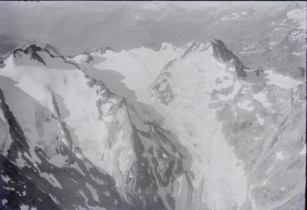
Piz Por (left) and Surettahorn (right). An aerial photo from 1923 from 3400 m
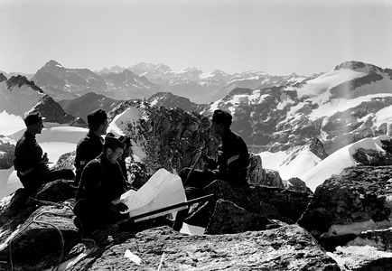
Officers during the First World War on the suretta maple


literature
- Manfred Hunziker: Club guide, Bündner Alps . Obverse. 1st edition. tape III . Verlag des SAC, 1994, ISBN 3-85902-140-0 , p. 106-109 .
- Vital Eggenberger: Ski touring North Grisons . Verlag des SAC, 2008, ISBN 978-3-85902-270-6 , p. 356-360 .
- Vital Eggenberger: Ski tours in Graubünden. To 500 worthwhile summit destinations . 5th edition. Verlag des SAC, 1999, ISBN 3-85902-171-0 , p. 268-270 .
- Fabian Lippuner, David Coulin: Alpine hiking / summit destinations, Graubünden North . Verlag des SAC, 2013, ISBN 978-3-85902-341-3 , p. 180-183 .
- National map of Switzerland, sheet 1255 Splügenpass, 1: 25,000, Federal Office of Topography, 2012 edition.
Web links
Individual evidence
- ↑ Andrea Schorta: How the mountain got its name . Small Rhaetian name book with two and a half thousand geographical names of Graubünden. Terra Grischuna Verlag, Chur and Bottmingen / Basel 1988, ISBN 3-7298-1047-2 , p. 137 .
- ↑ Calculated 360 ° panorama ( U. Deuschle ; information ) of the Suretta maple