Noce (Trentino)
|
Noce German: Nonsbach |
||
|
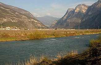
The noce at Mezzolombardo |
||
| Data | ||
| location | Italy | |
| River system | Etsch | |
| Drain over | Adige → Adriatic Sea | |
| River basin district | Eastern Alps | |
| source | at the Corno dei Tre Signori | |
| muzzle | at Zambana in the Adige Coordinates: 46 ° 8 ′ 49 " N , 11 ° 4 ′ 33" E 46 ° 8 ′ 49 " N , 11 ° 4 ′ 33" E
|
|
| length | 105 km | |
| Catchment area | 1,619.26 km² | |
| Outflow A Eo : 1,619.26 km²
|
MQ Mq |
46 m³ / s 28.4 l / (s km²) |
The Noce ( German Nonsbach or Ulz ) is a river in the north Italian Trentino . It rises at the 3360 m slm high Corno dei Tre Signori near the Gavia Pass in the Stelvio National Park and is 105 km long.
First, the Noce flows through the Pejo Valley , where it is dammed after a few kilometers in Lake Pian Palù , then it reaches the Sulztal , where it takes in the Vermigliana in Fucine , which collects the meltwater of the Presanella glacier from the Tonale Pass . On the right side comes from Passo Campo Carlo Magno in Dimaro of Meledrio-stream to and from the Rabbi Valley flows between Malè and Terzolas of Rabbies one. The Barnès brook from the Bresimo valley then forms the border between the Sulztal and the Non valley in the Mostizzolo gorge . Due to the glaciers in this large catchment area, the river carries a lot of water in summer.
The Noce receives the Rio Pescara from Proveis and Rumo in the Mostizzolo gorge and feeds the Lago di Santa Giustina at Cles . The largest tributary is the Novella coming from the Gampenpass , which flows into the Lago di Santa Giustina like a fjord when the water is high . Smaller tributaries on the right are the Tresenga from the Tovel Valley, the Lovernatico and just before the Rocchetta the Rio Sporeggio . On the left there are the Rio San Romedio , the Pongaiola and the Rinascico , which have dug particularly deep gorges in the limestone layers of the Mendel ridge . After emerging from the Rocchetta, it flows through the Rotaliana plain and finally flows into the Adige at Zambana . Before the river was regulated between 1849 and 1852, the Noce flowed into the Adige about 6 kilometers further north near St. Michael an der Etsch (San Michele all'Adige).
Web links
Individual evidence
- ↑ 2014 Ministero dell'Ambiente: Geoportale Nazionale , Fachdienst Bacini hidrografici principale , 2014 (accessed on June 29, 2015)
