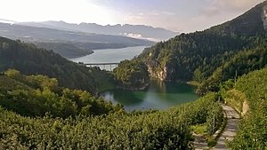
Santa Giustina Dam
| Santa Giustina dam, Lago di Santa Giustina |
|||||||
|---|---|---|---|---|---|---|---|
|
|||||||
|
|
|||||||
| Coordinates | 46 ° 21 '26 " N , 11 ° 3' 23" E | ||||||
| Data on the structure | |||||||
| Lock type: | Arch dam | ||||||
| Construction time: | 1946-1950 | ||||||
| Height above valley floor: | 102.50 m | ||||||
| Height above foundation level : | 152.50 m | ||||||
| Height of the structure crown: | 532.50 m | ||||||
| Building volume: | 112 000 m³ | ||||||
| Crown length: | 124.20 m | ||||||
| Power plant output: | 34.5 MW | ||||||
| Operator: | Dolomiti Edison Energy srl. | ||||||
| Data on the reservoir | |||||||
| Altitude (at congestion destination ) | 530 m (445-553 m) | ||||||
| Water surface | 3.5 km² | ||||||
| Reservoir length | 6 km | ||||||
| Reservoir width | 1 km | ||||||
| Storage space | 182.81 million m³ | ||||||
| Design flood : | 1 008 m³ / s | ||||||
The Santa Giustina dam in Val di Non in Trentino in Italy dams the Noce to the Santa Giustina Lake ( Lago di Santa Giustina ). The arch dam was built from 1946 to 1950 and inaugurated in 1951. When it was built, it was the highest dam in Europe with a total height of 152.50 m and it is still one of the largest dams on earth.
The dam was built for the purpose of generating energy. The planning engineer was Claudio Marcello. It belonged to the energy group Edison SpA and went to Dolomiti Edison Energy srl in 2008. about, one of Edison and the majority owner Dolomiti Energia Spa. operated company.
The storage space of the reservoir is a total of 182.81 million cubic meters, of which 171.67 million m³ are usable storage space.
See also
- List of the largest dams on earth
- List of the largest reservoirs on earth
- List of the largest hydroelectric plants in the world
- List of dams in the world # Italy
literature
- Renzo Dori: Le grandi derivazioni idroelettriche del Trentino. Fondazione Museo Storico del Trentino, Trento 2015. ISBN 978-88-7197-201-5
Web links
Commons : Santa Giustina Dam - Collection of images, videos and audio files
Individual evidence
- ^ Renzo Dori: Le grandi derivazioni idroelettriche del Trentino , p. 176
- ↑ Dolomiti Edison Energy - Società (Italian) accessed on January 3, 2019

