
Padon comb
| Padon comb | |
|---|---|
 La Mesola from the east |
|
| Highest peak | La Mesola ( 2727 m slm ) |
| location | Provinces of Trento and Belluno , Italy |
| part of | Marmolatagruppe , Dolomites , Eastern Alps |
| Classification according to | AVE 52 |
| Coordinates | 46 ° 28 ′ N , 11 ° 52 ′ E |
| rock | Volcanite |
| Age of the rock | Middle Triassic |
| particularities | Volcanic structure, scene of the mountain war |


The Padonkamm (also Padónkamm , Italian Crepes de Padon ) is a comparatively unknown mountain ridge in the Dolomites . Most of it runs along the border between the Italian provinces of Trento and Belluno . The highest point is La Mesola (also Bec de Mezdi or Sass de Mezdi ) with 2727 m slm
Location and surroundings
The Padon ridge stretches from the Pordoi Pass south-east and runs out towards Rocca Pietore . In the north and east, the mountain range is bounded by the upper Buchenstein valley with the town of Arabba , and to the south lies the Passo Fedaia with the reservoir of the same name . The Fassa Valley connects to the west with the municipality of Canazei . Adjacent mountain groups are the Sella Group in the north and the Marmolada in the south.
The highest peak La Mesola has a dominance of 2.8 km to the Sasso d'Undici ( 2801 m ) and a notch height of 488 m to the Pordoi pass.
geology
The rocks of the Padon ridge appear dark and heavily weathered compared to the surrounding mountain groups. The reason for this is the volcanic origin , to which the geological structure of the neighboring Col di Lana can be traced back. The deposits originated from solidifying lava outflows in the Pennine Ocean of the middle Triassic . Their lower hardness compared to dolomite rock makes them more susceptible to all kinds of weathering processes , which also explains the lower altitude.
history
Like many other parts of the Dolomites, the Padon ridge was the scene of bitter fighting during the First World War . In addition to a reconstructed suspension bridge, numerous caverns , dilapidated positions , a former field kitchen and two re-accessible tunnels that repeatedly open up to the Austrian- occupied Marmolata glacier testify to the horrors of war .
A leveling on the eastern summit of the Mesola served the Italians to position headlights with which the Col di Lana, which was also occupied by Austria, was illuminated.
tourism
The Via Ferrata delle Trincée (German: Schützengraben-Steig), a popular via ferrata that winds along warpaths over the ridge and is very exposed in places , leads over the wildly rugged, central Padon ridge. The climb with difficulty D should only be climbed by absolutely sure-footed and vertigo-free mountaineers with a certain amount of experience. As an extension of the “Trincée” , the Alta via delle Creste (German: Grate-Höhenweg) is popular, where two tunnels (headlamp required) have to be passed. The Sentiero Geologico di Arabba runs parallel to the south .
The Bindelweg , which is an easy hike along the south side of the western ridge , is also very popular . Parts of the route were originally used as a trade route that mainly transported flour . You can also often find mountain bikers who use the well-developed hiking trails. In summer 2016, a separate trail network is to be opened with Porta Vescovo as the center.
In winter the Padon ridge is part of the Sella Ronda . The Forcella Europa ( 2538 m ) and the slightly lower Porta Vescovo represent the highest points of this popular ski area . There are several lifts on the north side that connect the ski areas of Arabba and Malga Ciapela -Marmolata. The gondola lift to the Porta Vescovo and the chair lift to the Passo Padon can also be used as a lift in summer. In the west, the "Belvedere" ski area , which belongs to Canazei and is named after the second highest peak of the Padon ridge, borders on the rock group "Sasso Becce", which marks the western end point of the Padon chain.
summit
The following peaks exist in the Padonkamm in order of altitude:
- La Mesola (Bec de Mezdi) ( 2727 m )
- Belvedere ( 2650 m )
- La Mesolina (Monte Mesola) ( 2642 m )
- Le Forfes ( 2585 m )
- Col del Cuc ( 2563 m )
- Sass Ciapel ( 2557 m )
- Cima Crode Larice ( 2535 m )
- Sasso Becce ( 2534 m )
- Monte Padon ( 2512 m )
- Monte Laste ( 2438 m )
- Monte Migogn ( 2384 m )
- Sass de Roi ( 2372 m )
- Monte Foppa ( 2203 m )
bases
- Bivacco Bontadini ( 2552 m )
- Rifugio Luigi Gorza , Porta Vescovo ( 2478 m ), only open in winter
- Rifugio Viel dal Pan ( 2432 m ), only open in summer
- Rifugio Passo Padon ( 2407 m )
- Rifugio Fredarola ( 2400 m )
- Rifugio Sass Becè ( 2380 m )
- Rifugio Migon ( 1660 m )
photos
Cavern east of La Mesola

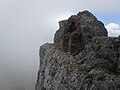
Eastern section of the central Padon ridge
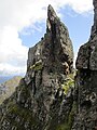
Wildly rugged ridge on the Via delle Creste

View from the Padonkamm to the Marmolada

Padon ridge from Lake Fedaia - south bank

North side of the Padon ridge, from the Pordoi pass

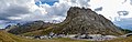
Padonkamm north side. The Mesola towers on the left, Sass Cappello on the right

Sasso-Becce rocks on the Pordoi pass

South side of the Padon ridge
North side of the Padon ridge


Web links
Individual evidence
- ↑ Formation of the Dolomites. Suedtirol.com, accessed on August 30, 2015 .
- ↑ Horst Höfler & Paul Werner: Via ferrata in the Dolomites. With the Vicentine Alps, Brenta and Lake Garda mountains. Bergverlag Rother , Munich 2000, pp. 68-69. ISBN 3-7633-3096-8 .
- ↑ Ferrata delle Trincée. Bergstieg.com, accessed August 30, 2015 .
- ↑ Rifugio Viel dal Pan. Rifugio Viel dal Pan, accessed August 30, 2015 .
- ↑ Mountain bike network from summer 2016. Dolomiti.it, accessed on August 30, 2015 .
- ↑ Cable car operating times. Fassa.com, accessed August 30, 2015 (Italian).