Sellaronda
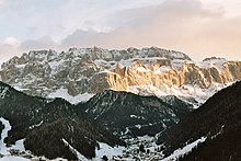
The Sella Ronda (Italian), German: the Sella Ronda , is a Skirundtour and circuit around the Sella massif in South Tyrol and Trentino.
Here you cross the passes Sella ( Ladin Jëuf de Sella Italian, Passo Sella west), Pordoi ( Pordoi , Passo Pordoi ) south, Campolongo ( Ciaulunch , Passo Campolongo ) east and Passo Gardena ( Jëuf de Frea , Passo Gardena ) north of the massif. The Sella Ronda can be used as a ski tour on official ski slopes in winter and by bike in summer . It leads through the Ladin valleys ofSouth Tyrol , Trentino and Veneto .
With skis
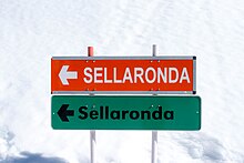
The round is over 26 kilometers of slopes (40 kilometers with cable car rides ) and, depending on the difficulty, is manageable by an average skier. The duration of the tour depends not only on skiing skills and weather conditions, but also on the utilization or overloading of the cable cars. It can be driven clockwise (orange direction signs) or counterclockwise (green). The feasibility of the Sella Ronda during the ski season is guaranteed on southern slopes and in valleys with snow cannons . The places Campitello , Canazei , Arabba , Corvara and Wolkenstein are suitable as starting points . Trips to the corresponding ski areas can be built individually. The Dolomiti Superski large-capacity ski pass is required for the Sella Ronda .
The Sella Ronda has been a complete chain of runs and ski lifts (initially only counterclockwise) since the 1970s, making it one of the first large-scale ski carousels .
The Sellaronda Skimarathon takes place every year, a night-time racing competition in which touring skis are used to circumnavigate the area (without using the lifts). The course record over the 42 km long route has been held since 2008 by the South Tyrolean Hansjörg Lunger and the Italian Guido Giacomelli with a total time of 3:15:07 hours. Since 2011, the Italians Francesca Martinelli and Roberta Pedranzini have held the women's course record with a total time of 3:55:12 hours.
By bike - Sella Ronda Bike Day and Sellaronda Hero
The four passes can also be conquered by bike on an asphalt road - in both directions, of course. The route is about 52 kilometers long and there are about 1650 meters of altitude to be overcome (only the lap, without getting there). There is a clockwise and anti-clockwise bus service that is set up for bicycles.
On two days a year, all Dolomite passes in Val Gardena and in the Sella area - Sella Pass, Grödnerjoch, Pordoi and Campolongo Pass - are exclusively available to ambitious cyclists and fit mountain bikers, so the road is closed to car traffic. It is then Volksradltag for everyone, or Sella Ronda Bike Day . On June 28, 2015, more than 22,000 participants attended the event. The start is in St. Christina and the 55 km long route has 1780 meters in altitude. The route is driven counter-clockwise.
The Sellaronda Hero has also been held annually since 2010. The Südtirol Sellaronda Hero is the toughest mountain bike marathon in Europe, in which mountain bikers reach Selva over a distance of 87 km or 60 km.
With the motorcycle
Another popular alternative is to do the "Sellaronda" circuit by motorcycle. The route is about 50 km long and takes about an hour, as this lap is quite demanding for the driver.
Individual evidence
- ↑ Sellaronda Skimarathon - Golden Book (All podium placements with finishing times)
- ↑ www.sellarondabikeday.com ( Memento of the original from August 20, 2007 in the Internet Archive ) Info: The archive link was inserted automatically and has not yet been checked. Please check the original and archive link according to the instructions and then remove this notice.
- ↑ http://www.alpen-motorradfahrer.com/motorradtouren/dolomiten/sellaronda
Web links
- General information about the Sellaronda
- Overview maps of the Sellaronda
- Sellaronda with skis Description of the Sellaronda in winter
- Sellaronda Detailed description of the Sellaronda
Coordinates: 46 ° 30 ′ 33.3 " N , 11 ° 45 ′ 33.2" E


