
Marmolata group
| Marmolata group | |
|---|---|
 Marmolatagruppe within the Dolomites (AVE 52) |
|
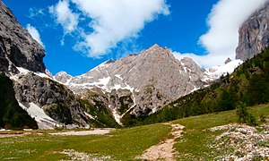
 Padonkamm and Marmolada from Sass Pordoi of view |
|
| Highest peak | Punta Penia ( 3343 m slm ) |
| location | Provinces of Trento and Belluno , Italy |
| part of | Dolomites |
| Coordinates | 46 ° 26 ' N , 11 ° 52' E |
The Marmolatagruppe ( Italian Gruppo della Marmolada ) is a mountain group in the Dolomites . It is located in the Italian regions of Trentino-Alto Adige and Veneto . Highest peaks of the group with 3343 m slm the PENIA the Marmolata ( Italian Marmolada ).
Demarcation
According to the Alpine Club division of the Eastern Alps, the Marmolatagruppe is bounded roughly as follows: to the northeast and east through the Cordevoletal from the Fanes group , the Ampezzaner Dolomites and the Civetta , to the south by the Passo San Pellegrino from the Palagruppe , to the west by the Fassatal from the Rosengarten group and the Langkofel group as well as to the north, through the Pordoi pass from the Sella group .
structure
The Marmolata group consists of several mountain ridges and mountain ranges . It resembles a trapezoid with the corner points Moena in the southwest, the Pordoi pass in the northwest, Andraz in the northeast and Cencenighe Agordino in the southeast, which is about 15 km long in the north and 25 km in the south. The ridges and sticks lying in front of the Marmolada to the south are also known as the Fassaner Dolomites.
Padon comb
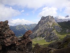
The extending in the east-west direction, primarily from volcanic existing Padonkamm , forms the northernmost subgroup of Marmolatagruppe. In the south it is separated from the Marmolada dolomite stock by the Passo Fedaia . The highest point of the Padon ridge is La Mesola with a height of 2727 m .
Marmolada
The Dolomite stock of the Marmolada forms the central and best known subgroup. It is bordered by the Fedaiapass in the north and by the Ombrettapass in the south. The Marmolada and Vernel, lying to the west and separated from the former by the Marmolada gorge, are the two cornerstones of the stick.
Ombretta-Ombrettola
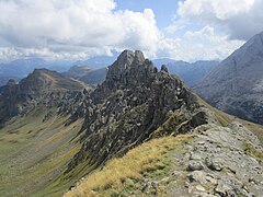
South of the Marmolada and separated from it by the Ombretta pass, the dolomite rock running north to south. Also known as the Cime de Ombreta. In the southeast it borders on the Forca Rossa notch on the Autakamm and in the southwest on Passo delle Cirelle on the Costabella - Cima Uomo crest. The highest point is the Sasso Vernale with 3058 m .
Costabella - Cima Uomo comb
The Costabella - Cima Uomo crest forms the central southern subgroup. It runs in the east from Passo delle Cirelle in a south-westerly direction to Passo delle Selle and borders here on the Monzoni - Vallaccia subgroup. The highest point is the Cima Uomo with 3010 m .
Colac'- Buffaure
Western subgroup, ridge located between the Contrintal in the north and the San Nicolò valley in the south. Buffaure, east of Pozza di Fassa in the Fassa Valley, forms the western end of the subgroup, while to the northeast of it the Colac 'closes the group to the Contrintal. The link between the two subgroups is formed by the intrusive rock Sas de Roces and the Croda Negra. The highest point is the Colac 'with 2715 m .
Monzoni - Vallaccia
The Monzoni - Vallacia subgroup forms the southwest corner point of the Marmolata group and consists of the two Monzoni and Vallacia ridges that give it its name. At the Passo delle Selle, the Monzoni ridge forms the western continuation of the Costabella - Cima Uomo ridge above the Val San Pellegrino. Like the Padon ridge, the Monzoni ridge consists of dark intrusive rock and thus stands out visually from the gray limestone neighbors . The Vallacia ridge borders the Monzoni ridge north of the La Costèla Scharte. The highest peaks are the Rizzoni 2645 m in the Monzoni and the Cima Vallaccia with 2637 m in the Vallacia .
Car comb
Subgroup located in the south-east between the Pettorina valley in the north and the Bioistal valley in the south. The ridge runs from the Forca Rossa saddle in the west to the Cime di Pezza and Piz Zorlet in the east. The Forca Rossa also represents the link with the Ombretta group. The Sasso Bianco, which lies in the far east and branches off from the Autakamm to the northeast, is also part of the Autakamm. The highest elevation of the little-traveled sub-group is the Cima dell'Auta Orientale (German: eastern tip of the car) at 2624 m .

Ombretta from the Ombrettatal
Colac '

Car comb
Vallaccia
Padon comb


summit
- Punta Penia 3343 m slm - Marmolada
- Punta Rocca 3310 m slm - Marmolada
- Gran Vernel 3210 m slm - Marmolada
- Sasso Vernale 3058 m slm - Ombretta-Ombrettola
- Cima Onbretta Orientale 3011 m slm - Ombretta-Ombrettola
- Cima Uomo (also Cima dell'Uomo) 3010 m slm - Costabella - Cima Uomo comb
- La Mesola 2727 m slm - Padon ridge
- Colac ' 2715 m slm - Colac' - Buffaure
- Cima Vallaccia 2637 m slm - Monzoni - Vallaccia
- Cima dell'Auta Orientale 2624 m slm - car crest
Glaciers and bodies of water
glacier

With the Marmolata glacier, the Marmolata group has the largest glacier in the Dolomites. The glacier retreat has also made itself significantly noticeable in the Marmolata group since the end of the Little Ice Age . In the oldest cadaster created by Carlo Porro over the glaciers in Italy in 1925, four glaciers were listed for the Marmolata group. In addition to the Marmolata glacier, these were the glaciers Vernel, Vernale and Val d'Ombert. Seven glaciers were listed in the cadastre established between 1957 and 1958, the main Marmolata glacier with 330 ha, the western Marmolata glacier with 57 ha, the lower and upper Vernel glacier with 2 ha each, the Vernale glacier with 28 ha, the Cima dell'Uomo glacier with 12 ha and the Ombretta Glacier with no size information. The increased number between 1925 and 1958 is due to the fragmentation of the glaciers due to glacier retreat and at the same time was accompanied by a reduction in the total glacier area.
This trend subsequently continued and even accelerated. Of the above-mentioned glaciers, the Cima dell'Uomo glacier and the Ombretta glacier had completely disappeared at the end of the 20th century, while the two Vernel glaciers had melted to the point that they were no longer officially listed as such. As the glacier retreated, several smaller glaciers were no longer connected to the Marmolata glacier. At the beginning of the 2000s, the Trentino mountaineering association SAT recorded five glaciers in the Marmolata group. These were the Marmolataha main glacier with 176.2 ha, the western Marmolata main glacier with 8.4 ha, the western Marmolata glacier with 11.8 ha, the glacier field in the summit area of the Marmolada with 12 ha and the lower Vernale glacier with 3.79 ha.
Rivers
The Marmolata group is drained on its east side by the Cordevole and on the west side by the Avisio . While the former flows into the Piave , the latter flows into the Adige . The watershed between the Adige and Piave runs between the Fedaiapass in the north and the San Pellegrino pass in the south over the Ombretta pass and the neighboring Ombretta-Ombrettola and Costabella - Cima Uomo-Kämme. The Contrin, San Nicolò and San Pellegrino streams, which drain the group through the valleys of the same name, form the tributaries of the Avisio. On the east side, the Rio Pettorina and the Torrente Biois from the valleys of the same name are the most important tributaries of the Cordevole coming from the Marmolata group.
geology
With the Marmolata limestone, the Contrin formation and the mineral- rich Monzoni group, after which the monzonite is named, the Marmolata group has three geological features.

The mountain range of the Marmolada, which with the Punta Penia is the highest point in the Dolomites, is not made of dolomite , but of limestone . Why the Triassic carbonate platform of the Marmolada did not turn into dolomite is not entirely clear. In addition to the Marmolada, the Vallacia floor in the Marmolata group and the central area around the Sasso Vernale in the Ombretta group also consist of the light gray Marmolata limestone. The latter is underlain by the Contrin Formation , which, like the Marmolatakalk, is a sedimentary rock layer and named after the Contrintal near Canazei . The latter forms a small inner-Alpine breakthrough zone with the Ombrettatal .
In contrast to the light Marmolata limestone, the dark rock masses of the Padon ridge, originating from volcanic activity, are at the northern end of the Marmolata group and the Monzoni group at the southwestern end of the group. However, volcanic rocks are not only found on the edges of the Marmolata group, but also east of Pozza di Fassa in the Buffaure-Colac 'group. This igneous rock comes from a super volcano that was active around 230 million years ago and was largely eroded by erosion. When the slowly cooling plutonites came into contact with the surrounding rock layers, the numerous minerals found in the Monzoni as well as solidified rocks such as the monzonite were formed through crystallization .
The minerals in the Monzoni Group were described in detail by Zepharovich , Doelter , Don Luigi Baroldi and Georg Gasser , who is considered the father of the South Tyrol Museum of Nature , between the end of the 19th and the beginning of the 20th century. The Monzoni are type localities for the gehlenite first described in 1815 by the mineralogist Johann Nepomuk von Fuchs . In addition, the Fassaite named after the Fassa Valley as well as Heulandite , Vesuvianite , Lizardite and wollastonite occur.
tourism
Refuges
- Rifugio Contrin , 2016 m slm , ANA, Marmolada
- Rifugio Falier , 2074 m slm , CAI , Marmolada
- Capanna Punta Penia , 3340 m slm , private, Marmolada
- Rifugio Monzoni , 2046 m slm , SAT , Monzoni - Vallaccia
- Rifugio Marmolada, 2054 m slm , private, Padonkamm
- Rifugio Baita Fredarola, 2388 m slm , private, Padonkamm
- Rifugio Vièl del Pan, 2432 m slm , private, Padon ridge
- Rifugio Migón, 1660 m slm , private, Padon ridge
- Rifugio Pian dei Fiacconi, 2625 m slm , private, Marmolada
- Rifugio Ghiacciao Marmolada, 2700 m slm , private, Marmolada
- Rifugio Melga Cianci, 1828 m slm , private, Marmolada
- Rifugio Buffaure, 2050 m slm , private, Colac'– Buffaure
- Rifugio Ciampàc, 2152 m slm , private, Colac'– Buffaure
- Rifugio Passo San Nicolò , 2338 m slm , private, Colac'– Buffaure
- Rifugio Tobià del Giagher, 2170 m slm , private, Colac'– Buffaure
- Rifugio Flora Alpina, 1800 m slm , private, Costabella - Cima Uomo crest
- Rifugio Fuciade, 1972 m slm , private, Costabella - Cima Uomo crest
- Rifugio Passo Le Selle, 2530 m slm , private, Costabella - Cima Uomo crest
- Rifugio Vallaccia, 2250 m slm , private, Monzoni - Vallaccia
- Rifugio Sasso Bianco, 1840 m slm , private, car ridge
- Rifugio Lagazzòn, 1356 m slm , private, car ridge
- Malga ai Lach, 1815 m slm , private, car comb
- Rifugio Baita ai Cacciatori, 1751 m slm , private, car ridge
Bivouac boxes
- Bivacco Marco Dal Bianco , 2727 m slm , CAI, Ombretta
- Bivacco Donato Zeni, 2100 m slm , SAT, Monzoni - Vallaccia
- Bivacco Ernesto Bontadini, 2552 m slm , CAI, Padonkamm
- Bivacco Giovanni Paolo I, 1852 m slm , CAI, car comb
- Baita Colmont, 1854 m slm , private, car comb
literature
- Franco de Battaglia, Luciano Marisaldi: Enciclopedia delle Dolomiti. Zanichelli, Bologna 2000.
- Michele Caldonazzi, Marco Avanzini: Storia geologica del Trentino. Società degli Alpinisti Tridentini , Trento 2011.
- Hannsjörg Hager, Heinz von Lichem : Marmolada Fassaner Dolomites. Bergverlag Rudolf Rother , Munich 1980.
- Società degli Alpinisti Tridentini - Sezione del CAI - Commissione Sentieri: … per sentieri e luoghi. Sui monti del Trentino. 3 Dolomiti Trentine Orientali. Corno Nero, Cornacci, Monte Agnello, Latemar, Catinaccio, Sassolungo, Sella, Marmolada, Valacia, Monzoni, Bocche, Pale di San Martino, Cimonega, Le Vette. Euroedit, Trento, 2015, ISBN 978-88-941381-0-8 .
- Luca Visentini: Gruppo della Marmolada. Athesia, Bozen 1994 ISBN 88-7014-779-7
Web links
Individual evidence
- ↑ Luca Visentini: Gruppo della Marmolada. P. 12
- ^ Franco de Battaglia, Luciano Marisaldi: Enciclopedia delle Dolomiti. P. 334
- ↑ Hansjörg Hager, Heinz von Lichen: Marmolada Fassaner Dolomiten p. 16
- ^ Franco de Battaglia, Luciano Marisaldi: Enciclopedia delle Dolomiti. P. 363
- ^ Franco de Battaglia, Luciano Marisaldi: Enciclopedia delle Dolomiti. P. 147
- ^ Franco de Battaglia, Luciano Marisaldi: Enciclopedia delle Dolomiti. Pp. 350-351
- ↑ Luca Visentini: Gruppo della Marmolada. Pp. 60-61
- ^ Franco de Battaglia, Luciano Marisaldi: Enciclopedia delle Dolomiti. P. 113
- ^ Ministero dei Lavori Pubblici - Servizio Idrografico (ed.): Elenco dei Ghiacciai Italiani. Rod. Tip. Orsatti & Zinelli, Parma 1925 p. 53
- ↑ Consiglio Nazionale delle Ricerche - Comitato Glaciologico Italiano (ed.): Catasto dei Ghiacciai Italiani - Anno geofisico 1957 - 1958. Comitato Glaciologico Italiano, Turin 1959 p. 112
- ^ Christian Casarotto: Ghiacciaio della Marmolada: Stato di salute. In: La Rivista. Bimestrale del Club Alpino Italiano luglio - agosto 2007 pp. 75–76
- ↑ Michele Caldonazzi, Marco Avanzini: Storia geologica del Trentino p. 84
- ^ A b Hannsjörg Hager, Heinz von Lichem : Marmolada Fassaner Dolomites. P. 17
- ↑ Michele Caldonazzi, Marco Avanzini: Storia geologica del Trentino, pp. 86-87
- ↑ Mirko Grisotto, Lodovico Grisotto: La Vesuvianite delle Dolomiti. Sulle orme dei ricercatori del secolo XIX. In: Gruppo Mineralogico Romano (ed.): Il Cercapietre N. 1–2 / 2010 Rome 2011. pp. 31–40 PDF
- ^ Società degli Alpinisti Tridentini - Sezione del CAI - Commissione Sentieri: … per sentieri e luoghi. Sui monti del Trentino. 3 Dolomiti Trentine Orientali. Corno Nero, Cornacci, Monte Agnello, Latemar, Catinaccio, Sassolungo, Sella, Marmolada, Valacia, Monzoni, Bocche, Pale di San Martino, Cimonega, Le Vette. P. 42
