Sassolungo Group
| Sassolungo Group | |
|---|---|
|
Langkofel in red on the map of the Dolomites |
|
|
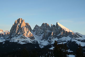
The Langkofel group in the sunset. |
|
| Highest peak | Langkofel ( 3181 m slm ) |
| location | Trentino Alto Adige , Italy |
| part of | Dolomites |
| Coordinates | 46 ° 31 ' N , 11 ° 44' E |
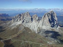
The Langkofel Group is a mountain range in the western Dolomites . It is located between Val Gardena (in the north) and the Fassa Valley (in the south), as well as the Sella massif (in the east), the Rosengarten (in the south-west) and the Schlern group (in the west). The Alpe di Siusi lies northwest of the Sassolungo Group . The highest point is the Langkofel, which gives it its name, with a height of 3,181 meters. The summits of the Sassolungo group as a whole form an arc that only opens to the northwest and thus has a kind of inner courtyard.
geology
The area arose in the time of the early Triassic (approx. 230 million years ago) as a coral reef in the tropical shallow sea, whereby hard limestone could form on the outside of the reef , while the rock inside remained fragile and after the uplift of the mountains could be washed out quickly. The mountain wreath of (clockwise) Langkofel , Langkofeleck, Fünffingerspitze , Grohmannspitze , Innerkoflerturm, Zahnkofel and Plattkofel was preserved .
summit
- Langkofel , 3181 m
- Grohmannspitze , 3113 m
- Innerkofler Tower , 3081 m
- Zahnkofel , 3000 m
- Five-finger tip , 2918 m
- Plattkofel , 2964 m
- Langkofelkarspitze , 2821 m
Mountain huts
- Langkofelhütte (2256 m, also Rifugio Vicenza, in the Langkofelkar)
- Emilio Comici Hut (2153 m, private, at the foot of the Langkofel)
- Toni Demetz Hut (2685 m, private, in the Langkofelscharte)
- Friedrich-August-Hütte (2298 m, private, on the Friedrich-August-Weg from Sella Pass to Plattkofelhütte)
- Des Alpes Hut (2395 m, private, on the Col Rodella, cable car from Campitello di Fassa)
- Sandro-Pertini-Hütte (2300 m, private, on the Friedrich-August-Weg)
- Plattkofelhütte (2300 m, private, west of the Plattkofel)
- Schutzhaus Sellajoch (2180 m, private, on the road to the Sellajoch below the pass)
- Williamshütte (2100 m, private, at the foot of the Plattkofel)
Tourist development
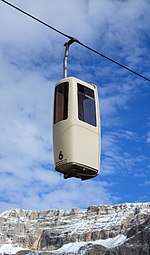
In summer, a gondola lift leads from the Sella Pass into the Langkofelscharte to the Toni Demetz refuge. From there, both the Langkofel (via the Langkofelhütte, Confinboden and the Emilio-Comici-Hütte) and the Plattkofel (via the Langkofelhütte, Plattkofelhütte and Friedrich-August -Weg ) can be circled on hiking trails. The Plattkofel can be reached from the Langkofelkar via the Oskar-Schuster-Steig, which has been developed as a via ferrata , and from the Plattkofelhütte via the steep west flank (here without climbing). The rockfall area of the “Stone City” stretches from the Langkofel slopes to the Sella Pass, remarkable above all for its rich flora.
In winter, at the foot of the Sassolungo Group, the ski areas Col Rodella (on the Sella Pass) , Plan de Gralba, Ciampinoi (with the famous Saslong World Cup run) and Monte Pana / Mont de Sëura are located. The famous Sella Ronda , a circuit of the Sella group on ski slopes clockwise or counter-clockwise, makes use of these slopes.


