Plattkofel
| Plattkofel | ||
|---|---|---|
|
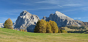
The Plattkofel (right, easily recognizable by its flat flank) with the other mountains of the Langkofel group |
||
| height | 2964 m slm | |
| location | Border between South Tyrol and Trentino , Italy |
|
| Mountains | Sassolungo Group , Dolomites | |
| Dominance | 0.5 km → Zahnkofel | |
| Notch height | 200 m ↓ Plattkofelscharte | |
| Coordinates | 46 ° 30 '48 " N , 11 ° 42' 59" E | |
|
|
||
The Plattkofel ( Italian Sasso Piatto , Ladin Sas plat ) is a 2964 m high mountain in the Langkofel group in the Dolomites . The name refers to the flat western flank facing the Alpe di Siusi .
topography
The Plattkofel is the westernmost mountain in the Langkofel group between Val Gardena in South Tyrol and the Fassa Valley in Trentino . While the eponymous western flank rises quite evenly and relatively flat to the summit ridge, the eastern flank breaks off suddenly and steeply to the Plattkofelkar . The summit ridge, which runs roughly in a north-west-south-east direction, has three summit points. The most important for tourists is the central summit ( 2958 m ) with a summit cross, which can be reached via marked trails . However, the highest point of the mountain is found at the southeast peak at an altitude of 2964 m , while the northwest peak has a height of 2954 m .
The three municipalities of Castelrotto , S. Cristina in Val Gardena (both South Tyrol) and Campitello di Fassa (Trentino) meet at the central summit .
Climbs
The Plattkofel is the only mountain in the Langkofel Group that can be hiked. The much-used path no. 527 leads from the Plattkofelhütte over the western flank to the central summit. From the east from the Langkofelkar with the Oskar-Schuster-Steig, a via ferrata (I-II, partly secured with ropes, named after Oscar Schuster ) also leads to the middle summit.

