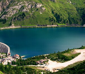
Fedaia reservoir
| Fedaia reservoir | |||||
|---|---|---|---|---|---|
| The western end of the Fedaia reservoir from the south | |||||
|
|||||
|
|
|||||
| Coordinates | 46 ° 27 '24 " N , 11 ° 52' 47" E | ||||
| Data on the structure | |||||
| Construction time: | until 1956 | ||||
| Height of the barrier structure : | 57 m | ||||
| Crown length: | 622 m | ||||
| Base width: | 43 m | ||||
| Power plant output: | 20 MW | ||||
| Data on the reservoir | |||||
| Altitude (at congestion destination ) | 2057 m slm | ||||
| Reservoir length | 1.62 km | ||||
| Reservoir width | 500 m (max.) | ||||
The Fedaia reservoir ( Lago di Fedaia in Italian , Lèch de Fedaa in Ladin ) is a dam system near the Fedaiapass at an altitude of around 2050 m in the Dolomites in Trentino (Province of Trento) in Italy . It serves both to generate electrical energy and to protect against floods.
The reservoir lies between the northern slope of the Marmolada and the Padon ridge north of the lake . The road from Canazei to Rocca Pietore (SS 641) runs along the north bank of the lake . The river Avisio , which has its source in the Marmolada glacier and continues through the Fassa Valley , is dammed .
Because of its location near the pass and the lateral inflow from the Marmolada, the lake has two dams. The main barrier to the west of the Fassa Valley is a concrete wall with a maximum height of 57 meters and a base width of 43 meters. It is made up of two straight pieces that are slightly angled against each other and one curved one around the point of the greatest wall height. It is a total of 622 meters long and, because of its shape, longer than the breadth of the lake. A driveway leads over them.
In the east, in the direction of the pass, which is only a few meters higher, a 270-meter-long straight debris dam secures the valley. Below the dam, about 15 meters lower than the water level of the reservoir, lies the small natural Fedaia lake of about 100 by 150 meters, which is sealed off to the east by the top of the pass. The distance between the two dams and thus the length of the reservoir is 1.62 km.
The power station belonging to the plant with a capacity of 20 megawatts went on line in 1956.
literature
- Aldo Gorfer: Le Valli del Trentino. Guida geografica-storico-artistico-ambientale. Trentino Orientale , Manfrini, Calliano 1977.
- Gino Tomasi: I trecento laghi del Trentino , Artimedia-Temi, Trento 2004 ISBN 88-85114-83-0
Web links
Individual evidence
- ↑ Aldo Gorfer: Le Valli del Trentino. Guida geografica-storico-artistico-ambientale. Trentino Orientale. P. 666


