
Val Montanaia
| Val Montanaia | ||
|---|---|---|
 |
||
| location | Friuli Venezia Giulia , Italy | |
| Waters | Rio Val Montanaia | |
| Mountains | Friulian Dolomites | |
| Geographical location | 46 ° 23 '13 " N , 12 ° 28' 54" E | |
|
||
| Type | Kerbtal | |
| rock | Sedimentary rocks | |
| height | 1244 to 2333 m slm | |

The Val Montanaia (German: Montanaia Valley) is a short and narrow side valley of the Val Cimoliana in the Friulian Dolomites ( Friuli-Venezia Giulia region , Italy ). It is known for the Campanile di Val Montanaia , a rock needle of 2173 m slm height. The campanile is almost at the end of the valley, which initially runs roughly in a north-south direction and then "branches off" to the northeast.
The valley lies within the Monfalcon Group and is bounded in the west and northwest by Pala Grande (2385 meters) and Cima Toro (2355 meters), and in the east by the slightly lower Cima Meluzzo and Cima Montanaia . At the head of the valley rises the highest mountain in the group at 2548 meters, the Cima Monfalcon di Montanaia .
The Dolomites high path number 6 ("Path of Silence") leads through the valley . Immediately north of the Campanile is the Perugini bivouac box , and the Pordenone mountain hut at the entrance to the valley .
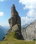
The campanile

Bivacco Perugini with the Forcella Val Montanaia (2333 m)
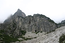
In the west of the valley
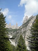
Middle valley area


