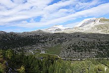
Fanes (plateau)
The Fanes is a plateau in the South Tyrolean Dolomites . The by Karen laced Karst - pool expands at an altitude of about 2000 m slm out. The Limojoch ( 2174 m , Ju de Limo ) roughly divides the area into a northern and a southern half.
Location and surroundings
The Fanes is located in the south-east of South Tyrol in Italy . It belongs entirely to the municipality of Marebbe in Ladinien and is under protection in the Fanes-Senes-Braies Nature Park . It is roughly surrounded by mountains of the Fanes group of the Dolomites. These include the Neuner ( 2968 m , Sas dles Nü ) and the Antonispitze ( 2655 m , Piz de Sant'Antone ) in the north, the Zehner ( 3026 m , Sas dles Diesc ) and the Heiligkreuzkofel ( 2907 m , Sas dla Crusc ) in the northwest ), in the southwest of the Piz Lavarela ( 3055 m ) and the Piz Cunturines ( 3064 m , Piz dles Cunturines ), in the south the southern ( 2980 m ), the northern ( 2969 m ) and the Middle Fanisspitze ( 2889 m ) with the Cima Scotoni ( 2874 m ), in the southeast of the Monte Cavallo ( 2911 m ), the Monte Casale ( 2898 m ) and the Monte Castello ( 2817 m ), and in the east of the Col Bechei ( 2794 m ).
topography
The Fanes is characterized by a constant change between alpine lawn mats, towering rock formations , rock troughs with small bodies of water and the last little stone pine forests. Mountain streams drain the plateau northwards into the Rautal , south into the Abteital and east to the Valle del Boite .
Near the Fanes Hut there is a well-known rock formation called the Parliament of the Marmots . Here the dolomite rock steps in low steps to a mountain lake, giving the impression of a natural amphitheater .
Man and Fanes
The Fanes is the scene of numerous South Tyrolean legends that revolve around the kingdom of the Fanes .
The name of the plateau is attested as early as the 11th century as Uanna (approx. 1002-1004), from which the forms Pfannes (1434) and Fannes (1448) developed in the course of the 15th century .
In the north of the plateau, the Alm Klein-Fanes is used as pasture, a little to the southeast and separated by the Limojoch the Alm Groß-Fanes.
Climbers and hikers, mainly from the southwest to San Cassiano or from northern San Vigilio over Pederü ascend to Fanes, serve the Fanes Hut and Lavarella as bases.
literature
- Peter Ortner , Christoph Mayr: South Tyrolean nature guide . Athesia, Bozen 1977, pp. 185-199
- Peter Kübler: Fanes: History - Landscape - Alpinism . Karlsruhe 2014, ISBN 978-3-9816744-0-8
Individual evidence
- ↑ Hiking in South Tyrol: Fanesalm, on the Internet: https://www.diewanderer.it/fanesalm/
- ^ Egon Kühebacher : The place names of South Tyrol and their history . Volume 3, Athesia, Bozen 2000, ISBN 88-8266-018-4 . Pp. 62-63.
Coordinates: 46 ° 36 '24.8 " N , 11 ° 59' 5.6" E

