Antoni peak
| Antoni peak | ||
|---|---|---|
|
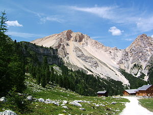
Antonispitze from the southeast, from Kleinfanes |
||
| height | 2655 m slm | |
| location | North of the Fanes | |
| Mountains | Fanes group | |
| Dominance | 0.75 km → Neuner | |
| Notch height | 189 m ↓ Antonijoch | |
| Coordinates | 46 ° 37 '49 " N , 12 ° 0' 15" E | |
|
|
||
The Antonispitze (also Sankt Antonispitze , Antoniusspitze or Fanessattelspitze , Ladin Piz de Sant'Antone , Italian Monte Sella di Fanes , 2655 m slm ) is a mountain in the Fanes group . From the Kleinfanesalm she belongs with her big, bright limestone rubble flanks adjacent to the iron fork tip of the most striking mountain shapes. The Antonijoch (also Fanesjoch , 2466 m ) separates the mountain from the Neuner ( 2968 m ), a little less than two kilometers to the west . The massif is under protection in the Fanes-Senes-Braies Nature Park .
Climbs
Usually the ascent takes place over the Antonijoch. From there it takes about half an hour to get to the summit on an unmarked trail. The Antonijoch can be reached either from the south, from the Lavarella hut on the Fanes plateau , or from the north, from the Wengen Valley , on marked paths.
Literature and maps
- Franz Hauleitner: Dolomites 3. Val Badia - From Bruneck to Corvara. 4th edition, Munich 2010, ISBN 978-3-7633-4060-6
- Topographic hiking map, Dolomiti di Braies / Pragser Dolomiten - Marebbe / Enneberg , sheet 031, 1: 25,000, Casa Editrice Tabacco , ISBN 88-8315-031-7

