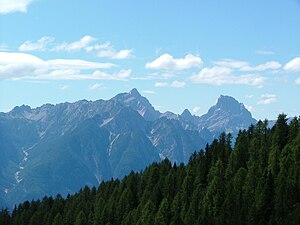
Cima dei Preti
| Cima dei Preti | ||
|---|---|---|
|
Monte Duranno ( 2668 m ) and Cima dei Preti |
||
| height | 2706 m slm | |
| location | Veneto / Friuli-Venezia Giulia border , Italy | |
| Mountains | Southern Carnic Alps | |
| Dominance | 17.53 km → Antelao | |
| Notch height | 1417 m ↓ Cima Sappada | |
| Coordinates | 46 ° 20 '33 " N , 12 ° 25' 16" E | |
|
|
||
| First ascent | Maurice Holzmann and Santo Siorpaes on September 23, 1874 | |
| Normal way | South side, II degree , PD | |
The Cima dei Preti is at 2706 m slm the highest mountain in the Southern Carnic Alps . It is located north of Cimolais on the border between the regions of Veneto and Friuli-Venezia Giulia .
The normal route leads from the Ponte Compol in Val Cimoliana via the Bivacco Greselin in 5 hours over the south side to the summit. Difficulties of difficulty level II (UIAA) or PD (SAC) have to be overcome.
Web links
- Cima dei Preti on Peakbagger.com (English)
Individual evidence
- ↑ Normal route to the Cima dei Preti (vienormali.it) Italian, accessed on April 11, 2009

