Valsugana
| Valsugana | |
|---|---|
|
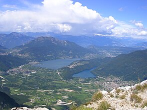
Upper Valsugana on the left the Lago di Caldonazzo, on the right the Lago di Levico, in front of it the place Levico Terme |
|
| location | Trentino , Italy |
| Waters |
Lake Caldonazzo , Lake Levico , Brenta |
| Mountains | Fiemme Valley Alps , Vicentine Alps |
| Geographical location | 46 ° 3 ′ 0 ″ N , 11 ° 27 ′ 0 ″ E |
The Valsugana (also Val Sugana , German occasionally Suganertal or Suganatal ) is a valley in Italy in the southeast of Trentino east of Trento on the border with Veneto .
The upper reaches of the Brenta flows through the Suganer Valley . It forms a gateway to the province of Vicenza . Bassano del Grappa is the first larger town in Veneto. The Brenta flows mainly from west to east in the upper half of the valley and south in the lower half.
Valley communities and localities
The Valsugana is divided into two valley communities :
- the Obertal belongs to the Comunità Alta Valsugana e Bersntol
- the lower valley to the Comunità Valsugana e Tesino
The first significant place of the Valsugana is Pergine Valsugana (German Fersen im Suganertal ). The Fersental branches off north of Pergine , a linguistic island of the Fersentalerischen (Bersntolerischen). Down the river there are two large lakes, Lago di Caldonazzo and Lago di Levico , which are suitable for swimming. The health resort Levico Terme (German Löweneck ), a seaside resort known since the 19th century with the flair of the fin de siècle , is located directly in the lake area. The townscape of Borgo Valsugana (German castle in Suganertal ), which is already in the middle part of the valley, is shaped by the Middle Ages and Baroque and by the houses adorned with balconies that lie directly on the Brenta.
history
The Valsugana is a tourist and fruit growing area. But it wasn't always so peaceful here: During the Alpine War of World War I , the area was fiercely fought over, as the border between Austria-Hungary and Italy ran in the immediate vicinity south across the plateau of Lavarone ( Lafraun in German ) over the Astico Gorge. The so-called Sugana Valley at that time lay at the foot of the Alpine Corps that supported the Austrians . From 1908, in anticipation of war, Austria-Hungary began to massively fortify the southern borders of the empire. On the other side of the border, the Italians built their fortresses . A number of monstrous fortresses were built on the plateaus south of the Valsugana, which were masterpieces of military engineering at the time.
Most of the Austrian fortifications that withstood the attacking Italians from May 1915 (Italy declared war on the Central Powers on May 24, 1915) to May 1916, when the front was shifted further south by the May offensive of the Central Powers, were razed after the First World War . Some of the fortresses (Verle, Werk Lusern) are still so well preserved that you can still get an idea of the bitter battles of the Dolomite War. The fortress Werk Gschwent in Lavarone (German Lafraun ) was intentionally left standing. It can be visited, now houses a military history museum and gives a good insight into the fortress construction at that time.
Lusern , the most famous German-speaking island in Northern Italy, is located near Lavarone . The Lavarone plateau can be reached from the valley via a road that leads from Caldonazzo to the crossroads of Monterovere, the Kaiserjäger road laid out by the Austrian military , which offers a good view of the Valsugana and its lakes.
traffic
The Valsugana is traversed by the Strada Statale 47 della Valsugana (Trento - Padova), which has been expanded into a dual carriageway, and by the parallel Valsugana Railway (Trento - Venice).
Web links
- Max Gottlieb: The natural beauties of Austria. XV. So into the Sugana Valley !. In: Neue Freie Presse , Morgenblatt, No. 16583/1910, October 22, 1910, p. 20, top left. (Online at ANNO ).


