
Pergine Valsugana
| Pergine Valsugana | ||
|---|---|---|

|
|
|
| Country | Italy | |
| region | Trentino-South Tyrol | |
| province | Trento (TN) | |
| Coordinates | 46 ° 4 ' N , 11 ° 14' E | |
| height | 490 m slm | |
| surface | 54 km² | |
| Residents | 21,548 (Dec. 31, 2019) | |
| Population density | 399 inhabitants / km² | |
| Factions | 21 political groups, see administrative structure | |
| Adjacent communities | Baselga di Pinè , Trient , Fornace , Sant'Orsola Terme , Civezzano , Frassilongo , Vignola-Falesina , Novaledo , Levico Terme , Tenna , Altopiano della Vigolana , Caldonazzo , Calceranica al Lago | |
| Post Code | 38057 | |
| prefix | 0461 | |
| ISTAT number | 022139 | |
| Popular name | Perginesi or Perzenaitri | |
| Website | Pergine Valsugana | |

Pergine Valsugana (German outdated Persen or Fersen im Suganertal ) is a municipality with 21,548 inhabitants (as of December 31, 2019) in the province of Trento .
location
Located at the mouth of the Fersental in the Suganertal , the city is dominated by the history of Castel Pergine ( Persen Castle ). The spacious and sunny plain of Pergine ( Fersen ) is surrounded by mountains and wooded valleys.
history
The Pergine area was already populated in prehistoric times. After the conquest of the region, Pergine was on the eastern Via Claudia Augusta to Altino .
The name Pergine was first mentioned in 845. When the Principality of Trento was founded in 1027, Pergine was part of the new area. Pergine belonged to the diocese of Feltre until 1786 . In 1531 the jurisdiction of Pergine was transferred to the Prince Diocese of Trento in exchange for that of Bozen .
In the first half of the 16th century, Pergine experienced a heyday due to the mining industry located here . In the 18th century, the swamps in the south of the city were drained. In 1815 the prince-bishopric was dissolved and Pergine became part of what was then Tyrol . In 1919 Pergine came to Italy with the whole of Trentino . In 1928, 13 communities in the area were incorporated into Pergine, which has been called Pergine Valsugana ever since .
In 1955, the villages of Falesina and Vignola were separated from Pergine as Vignola-Falesina .
The Pergine insane asylum was built in 1881, and many patients from today's South Tyrol were also housed in this clinic . With the reform of psychiatry in Italy (1978), the Pergine Asylum lost its importance. In 2002 it was finally closed. As part of the option in South Tyrol , many South Tyrolean patients at the institution were brought to Germany from 1940 and killed there ( euthanasia ).
Administrative division
Pergine has 21 fractions : Canale, Canezza, Canzolino, Ciré, Costasavina , Ischia , Madrano (dt. Maderein ), Nogaré, San Cristoforo al Lago , Santa Caterina , Serso , Susa, Roncogno, Viarago, Vigalzano, Visintainer, Zivignago, Masetti, Zava, Fontanabotte and Assizi.
Sons of the city
- Giuseppe Vittorio Alberti d'Enno (1623–1695), Prince-Bishop of Trento
- Valerius Dejaco (1914–1983), politician
- Gianpaolo Ambrosi (* 1940), luge rider
Picture gallery
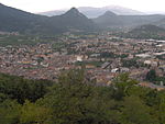
overview

town hall


Individual evidence
- ↑ Statistiche demografiche ISTAT. Monthly population statistics of the Istituto Nazionale di Statistica , as of December 31 of 2019.
- ↑ Historical overview on the website of the municipality in Italian , accessed on March 6, 2017.
- ^ History of the Pergine psychiatric institution in Italian (PDF; 112 kB), accessed on March 6, 2017.
- ↑ On the history of psychiatry in Italy and South Tyrol , accessed on March 6, 2017
Web links

Ala | Albiano | Aldeno | Altavalle | Altopiano della Vigolana | Amblar-Don | Andalo | Arco | Avio | Baselga di Piné | Bedollo | Besenello | Bieno | Bleggio Superiore | Bocenago | Bondone | Borgo Chiese | Borgo d'Anaunia | Borgo Lares | Borgo Valsugana | Brentonico | Bresimo | Caderzone Terme | Calceranica al Lago | Caldes | Caldonazzo | Calliano | Campitello di Fassa | Campodenno | Canal San Bovo | Canazei | Capriana | Carisolo | Carzano | Castel Condino | Castel Ivano | Castello Tesino | Castello-Molina di Fiemme | Castelnuovo | Cavalese | Cavareno | Cavedago | Cavedine | Cavizzana | Cembra Lisignago | Cimone | Cinte Tesino | Cis | Civezzano | Cles | Comano Terme | Commezzadura | Contà | Dambel | Denno | Dimaro Folgarida | Drena | Dro | Fai della Paganella | Fiavé | Florutz | Folgaria | Fornace | Garniga Terme | Repented | Giovo | Giustino | Grigno | Imer | Isera | Lavarone | Lavis | Ledro | Levico Terme | Livo | Lona-Lases | Lusern | Madruzzo | Malè | Massimeno | Mazzin | Mezzana | Mezzano | Mezzocorona | Mezzolombardo | Moena | Molveno | Mori | Nago-Torbole | Nogaredo | Nomi | Novaledo | Novella | Ospedaletto | Ossana | Palù del Fersina | Panchià | Peio | Pellizzano | Pelugo | Pergine Valsugana | Pieve Tesino | Pieve di Bono-Prezzo | Pinzolo | Pomarolo | Porte di Rendena | Predaia | Predazzo | Primiero San Martino di Castrozza | Rabbi | Riva del Garda | Romeno | Roncegno Terme | Ronchi Valsugana | Ronzo-Chienis | Ronzone | Rovereto | Roverè della Luna | Ruffrè-Mendola | Rumo | Sagron Mis | Samone | San Giovanni di Fassa | San Lorenzo Dorsino | San Michele all'Adige | Sant'Orsola Terme | Sanzeno | Sarnonico | Scurelle | Segonzano | Sella Giudicarie | Sfruz | Soraga di Fassa | Sover | Spiazzo | Spormaggiore | Sporminors | Stenico | Storo | Strembo | Telve | Telve di Sopra | Tenna | Tenno | Terragnolo | Terre d'Adige | Terzolas | Tesero | Tione di Trento | Sound | Torcegno | Trambileno | Tre Ville | Trento | Valdaone | Valfloriana | Vallarsa | Vallelaghi | Vermiglio | Vignola-Falesina | Villa Lagarina | Ville d'Anaunia | Ville di Fiemme | Volano | Ziano di Fiemme