
Molveno
| Molveno | ||
|---|---|---|

|
|
|
| Country | Italy | |
| region | Trentino-South Tyrol | |
| province | Trento (TN) | |
| Coordinates | 46 ° 9 ′ N , 10 ° 58 ′ E | |
| height | 864 m slm | |
| surface | 35 km² | |
| Residents | 1,111 (Dec 31, 2019) | |
| Population density | 32 inhabitants / km² | |
| Post Code | 38018 | |
| prefix | 0461 | |
| ISTAT number | 022120 | |
| Popular name | molvenesi | |
| Patron saint | San Carlo Borromeo | |
| Website | www.comune.molveno.tn.it | |

Molveno (German outdated: Malfein ) is an Italian commune ( comune ) with 1111 inhabitants (as of December 31, 2019) in the province of Trento , region of Trentino-South Tyrol . It belongs to the valley community Comunità della Paganella .
geography
The climatic spa and winter sports resort is located about 14 km north-north-west of Trento at an altitude of 864 m slm east of the Brenta Group on the shores of Lake Molveno and at the foot of the Paganella massif to the east .
The approximately 4 km long Molvenossee, which is up to 120 m deep, is fed by a small stream and several small tributaries from the mountains. The outflow is the Bondai brook, which flows south of San Lorenzo in Banale into the Sarca river , the main tributary of Lake Garda .
traffic
The state road SS421 from Ponte Arche to Mezzolombardo runs through the town. The next larger town is Andalo , 5 km away.
gallery

Town center with Brenta group
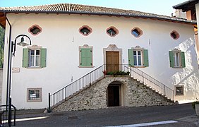
Palazzo Saracini (17th century)

View of Molveno across the lake. In the background the mountains of the Brenta group

View over Lake Molveno to the south

San Vigilio cemetery church (14th century)


Web links
Individual evidence
- ↑ Statistiche demografiche ISTAT. Monthly population statistics of the Istituto Nazionale di Statistica , as of December 31 of 2019.

Ala | Albiano | Aldeno | Altavalle | Altopiano della Vigolana | Amblar-Don | Andalo | Arco | Avio | Baselga di Piné | Bedollo | Besenello | Bieno | Bleggio Superiore | Bocenago | Bondone | Borgo Chiese | Borgo d'Anaunia | Borgo Lares | Borgo Valsugana | Brentonico | Bresimo | Caderzone Terme | Calceranica al Lago | Caldes | Caldonazzo | Calliano | Campitello di Fassa | Campodenno | Canal San Bovo | Canazei | Capriana | Carisolo | Carzano | Castel Condino | Castel Ivano | Castello Tesino | Castello-Molina di Fiemme | Castelnuovo | Cavalese | Cavareno | Cavedago | Cavedine | Cavizzana | Cembra Lisignago | Cimone | Cinte Tesino | Cis | Civezzano | Cles | Comano Terme | Commezzadura | Contà | Dambel | Denno | Dimaro Folgarida | Drena | Dro | Fai della Paganella | Fiavé | Florutz | Folgaria | Fornace | Garniga Terme | Repented | Giovo | Giustino | Grigno | Imer | Isera | Lavarone | Lavis | Ledro | Levico Terme | Livo | Lona-Lases | Lusern | Madruzzo | Malè | Massimeno | Mazzin | Mezzana | Mezzano | Mezzocorona | Mezzolombardo | Moena | Molveno | Mori | Nago-Torbole | Nogaredo | Nomi | Novaledo | Novella | Ospedaletto | Ossana | Palù del Fersina | Panchià | Peio | Pellizzano | Pelugo | Pergine Valsugana | Pieve Tesino | Pieve di Bono-Prezzo | Pinzolo | Pomarolo | Porte di Rendena | Predaia | Predazzo | Primiero San Martino di Castrozza | Rabbi | Riva del Garda | Romeno | Roncegno Terme | Ronchi Valsugana | Ronzo-Chienis | Ronzone | Rovereto | Roverè della Luna | Ruffrè-Mendola | Rumo | Sagron Mis | Samone | San Giovanni di Fassa | San Lorenzo Dorsino | San Michele all'Adige | Sant'Orsola Terme | Sanzeno | Sarnonico | Scurelle | Segonzano | Sella Giudicarie | Sfruz | Soraga di Fassa | Sover | Spiazzo | Spormaggiore | Sporminors | Stenico | Storo | Strembo | Telve | Telve di Sopra | Tenna | Tenno | Terragnolo | Terre d'Adige | Terzolas | Tesero | Tione di Trento | Sound | Torcegno | Trambileno | Tre Ville | Trento | Valdaone | Valfloriana | Vallarsa | Vallelaghi | Vermiglio | Vignola-Falesina | Villa Lagarina | Ville d'Anaunia | Ville di Fiemme | Volano | Ziano di Fiemme