
Lake Molveno
|
Lago di Molveno Molveno lake |
||
|---|---|---|

|
||
|
View of Molveno across the lake in northwest direction, with the Brenta group in the background |
||
| Geographical location | Brenta Group | |
| Tributaries | Rio Lambin, Rio Massodi, Rio Ceda | |
| Drain | Leachate → Torrente Bondai → Sarca → Lake Garda → Mincio → Po | |
| Places on the shore | Molveno | |
| Data | ||
| Coordinates | 46 ° 7 '32 " N , 10 ° 57' 40" E | |
|
||
| Altitude above sea level | 822 m slm | |
| surface | 3.41 km² | |
| length | 4.4 km | |
| width | 1.5 km | |
| volume | 0.161.2 km³ | |
| Maximum depth | 124 m | |
| Middle deep | 47 m | |

The Lago di Molveno (dt. Outdated: Malfeinsee ) is a lake in Trentino , Italy on the east side of the Brenta .
geography
The lake, located at an altitude of 822 m slm , is about 4.4 km long and up to 124 m deep. It lies to the west of the Adige in a cut that delimits the Brenta Group from the ridge of the Paganella –Monte Gazza to the east and runs down from Andalo to Stenico . After Lake Caldonazzo, it is the second largest lake that lies entirely in Trentino.
A wide peninsula extending into the lake on the rugged west bank in the middle of the lake gives Lake Molveno an uneven shape. Strada Statale 421 dei Laghi di Molveno e Tenno runs along the slightly more gently sloping east bank , while an old cart path runs along the west bank, which was once the only connection to Molveno from the south. This access path, which is now partly in the Adamello-Brenta Nature Park , was of some strategic importance and was accordingly fortified, as indicated by the so-called Napoleonic fortifications ( Italian Fortini di Napoleone ) on the peninsula reaching into the lake.
At the extreme northern tip there is a narrow indentation about 400 m and 60 m wide, which is regarded as an independent arm of the lake and bears the name Lago di Bior . In these, the Rio Lambin, the most important tributary flows into the lake. The catchment area of Lake Molveno is relatively small and is limited to Monte Gaza in the east, Passo di Andalo in the north and the Brenta in the west. It has no direct drain. However, its seepage water feeds the source of the Torrente Bondai, which is located below the lake. Until it was used to generate electricity in the 1950s, Lake Molveno was known for its crystal clear water. Until then, a visibility depth of 14 m could be measured using a Secchi disk . Its intense blue color, for which the lake was known, was due to the fact that there was very little phytoplankton in the water . Its temperate water means that it rarely freezes over.
The only place on the lake is Molveno on the north-west bank .
Emergence
The lake was created by a landslide that slipped from the south-western side after the last ice age , when the pressure on the mountain slopes there was reduced by the ice masses. Numerous tree stumps from a former forest, which were exposed in 1951, when the water level was lowered significantly during construction work for the intended electrical use of the lake, testify to this. The well-preserved stumps were mostly uprooted or damaged in the depression, the later lake bed, which suggests that the slope probably plunged into the depths quite abruptly. Using the radiocarbon method, it was possible to establish that Lake Molveno must have been formed around 1000 BC. On the basis of the wood samples taken, it was also possible to determine that the tree species in this forest, which was buried several thousand years ago, were identical to those found today. At the same time, various artifacts from the Iron Age were found that bear witness to a human presence at that time.
Use as a compensation pool
As early as 1925, the first plans were forged to use Lake Molveno to generate electricity by channeling the water from the upper reaches of the Sarca and the Torrente Arnò in Val Breguzzo near Bondo through several reservoirs and pumping stations into the lake and using it as a compensation basin for a lower one Kraftwerk should serve. In 1940, the Società Idroelettrica Sarca Molveno (SIM) was founded for this purpose . The first work on the project did not take place until after the Second World War in 1949.
In 1953 the first water was channeled from the upper reaches of the Sarca into Lake Molveno via a 5 km long tunnel through the Brenta. The inlet is in the southwest area of the lake. On the east bank, two downpipes lead through the Monte Gazza down to the cavern power station about 600 m below on the Lago di Santa Massenza in the Valle dei Laghi. The project originally envisaged that the water level should be up to 35 m above the natural water level. Due to violent protests by the population, the maximum water level was reduced to 15 m and the already built dam on the south bank was removed.
The water from Lake Molveno is also used to generate electricity at the Lago di Nembia cavern power station, which is almost 70 m below . An artificial drainage channel on the south bank of Lake Molveno serves as an overflow.
Its use as a compensation basin led to some changes in the lake's ecosystem . The inflow of the Sarca water, which is mainly fed by the glaciers of the Adamello-Presanella group , brought much colder and more sediment-rich water into Lake Molveno. The intervention also changed the oxygen content of the water, which had an impact on the fish population. The water level is exposed to considerable fluctuations due to the discontinuous water withdrawal and is lowest in the winter months. By the end of the 1980s, the extraction was set to a low of 740 m slm and was subsequently increased to 780 m slm , which is a difference of at a normal water level of 822 m slm , which is reached between the beginning of June and the end of September 43 m. In 2008, the use of the Enel was transferred to the Autonomous Province of Trento, which led to a further reduction in the maximum withdrawal, especially in the winter months
Fish fauna
Despite all the interventions, the following fish species can be found in Lake Molveno: Alburnus arborella (a species from the genus Alburnus ), brook trout , brook loach , Chondrostoma soetta or Italian Näsling (a species from the genus Chondrostoma ), chub , minnow , European eel , river perch , Bullhead , gudgeon , pike , carp , lukewarm , lavaret , marbled trout , roach , rudd , Rutilus erythrophthalmus (a species from the genus Rutilus ), lake trout , arctic char , tench , black pygmy catfish , wolffish and tiber barbel .
photos
 The Lake Molveno with the peninsula on the west bank
 Molveno on the north-west bank
 From the Napoleonic jumps north to the Andalo saddle
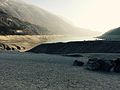 The lake that was heavily drained for repair work on the hydropower plant (2017)
 The partly drained lake with the Brenta in the background (2017)


_Italia_-_12_Agosto_2012_-_panoramio.jpg)


literature
- Aldo Gorfer: Le Valli del Trentino. Guida geografica-storico-artistico-ambientale. Trento Occidentale. Manfrini, Calliano 1975
- Ennio Lappi (Ed.): L'epopea dei grandi lavori idroelettrici in Giudicarie nell'archivio fotografico di Dante Ongari, Società degli Alpinisti Tridentini , Trient 2008 PDF
- Gino Tomasi: I trecento laghi del Trentino , Artimedia-Temi, Trient 2004, ISBN 978-88-85114-83-8 .
Web links
Individual evidence
- ↑ a b Gino Tomasi: I trecento laghi del Trentino pp. 258-259
- ↑ Ennio Lappi (Ed.): L'epopea dei grandi lavori idroelettrici in Giudicarie pp. 10-19
- ↑ Ennio Lappi (Ed.): L'epopea dei grandi lavori idroelettrici in Giudicarie p. 25
- ↑ Aldo Gorfer: Le Valli del Trentino. Guida geografica-storico-artistico-ambientale. Trento Occidentale pp. 480-481
- ↑ Municipality of Molveno - Environmental Protection Report 2016 (Italian) (PDF; 2.6 MB), accessed on May 11, 2018.
- ↑ Handbook for the budding sport fisherman of the Autonomous Province of Trento in Italian (PDF; 10.7 MB), accessed on May 10, 2018