
Tenno (Trentino)
| Tenno | ||
|---|---|---|

|
|
|
| Country | Italy | |
| region | Trentino-South Tyrol | |
| province | Trento (TN) | |
| Coordinates | 45 ° 55 ' N , 10 ° 50' E | |
| height | 428 m slm | |
| surface | 28 km² | |
| Residents | 2,012 (Dec. 31, 2019) | |
| Population density | 72 inhabitants / km² | |
| Post Code | 38060 | |
| prefix | 0464 | |
| ISTAT number | 022191 | |
| Popular name | Tennesi | |
| Patron saint | Immacolata Concezione | |
| Website | www.comune.tenno.tn.it | |

Tenno (in German formerly Thenn ) is an Italian municipality in the province of Trento (Region Trentino-Alto Adige ) with 2012 inhabitants (as of December 31, 2019). It is located 43 km southwest of Trento and 79 km northwest of Verona .
Administrative division
The municipality of Tenno is made up of four fractions , which in turn include several hamlets ( Italian Località ). The fractions, which were all independent municipalities until 1929, are Cologna-Gavazzo, Tenno (municipality seat), Ville del Monte and Pranzo . The 3 hamlets of Volta di No, Piazze and Teggiole are part of the Cologna-Gavazzo fraction. The hamlets of San Antonio, Calvola, Pastoedo, Canale, Lago di Tenno and Mattoni belong to the Ville del Monte fraction.
The neighboring municipalities are: Arco , Comano Terme , Fiavè , Ledro and Riva del Garda .

geography
Tenno is located in the hinterland of Lake Garda , a few kilometers north of Riva del Garda . The municipality of Tenno, also known as Tennese , extends from Gavazzo Nuova ( 201 m slm ) to the Rio Secco above Lake Tenno and includes the entire area in between.
Bounded in the east by Monte Misone ( 1803 m slm ) and its foothills, to the west lie the mountains of the Ledro group, which are in front of Monte Tombio ( 841 m slm ) and Monte S. Martino ( 1075 m slm ). Lake Tenno, which was dammed up by a landslide in the 12th century, lies below Monte Misone. The valley, which continues from the lake in a north-north-westerly direction and traversed by the Rio Secco, narrows and ends at the Passo di Ballino ( 755 m slm ), which is already in the municipality of Fiavè and represents the geographical border to the Outer Judiciaries . This upper northern area differs significantly from the southern, wider section through which the Rio Magnone flows and which is climatically influenced by the nearby Lake Garda.
This valley, named after the Rio Magnone, Valle di Magnone, was created by a glacier whose moraine has raised a terraced step at the southeast end of the valley on which the castle of Tenno lies. The magnone , which rises on the eastern slopes of the Corno di Pichea ( 2138 m slm ), has cut deep into the valley and overcomes the moraine level in an almost 100 m high gorge-like waterfall above Varone, a fraction of Riva del Garda, after which the waterfall, Cascata del Varone , also named. The second notable watercourse, the Rio Secco, in the northern area, has its source at the Dosso della Torta ( 2156 m slm ) and is the only significant tributary of the Tenno lake.
With the exception of Pranzo ( 463 m slm ), all places in the municipality are on the orographic left side of the valley.
The municipality of Tenno has been hit by landslides again and again in the recent past. In November 2000, after several days of heavy rain, a landslide of over 4 million cubic meters broke west of Lake Tenno, which not only changed the course of the Rio Magnone, but also the appearance of the valley.

history
Tenno was first mentioned in 1194 as Theni . As finds testify, the area around Tenno was inhabited as early as the Bronze Age. The place name probably goes back to a Longobard settlement, of which remains were found during excavations.
The location on an important road that connected the northern shore of Lake Garda with the Judicaria via the Passo Balino and the nearby Bocca di Trat pass , which was an important link to the Ledro Valley , were decisive for the development of the place and its castle . Historically, Tenno consisted of three districts, the so-called Ville del Piano , which were also otherwise clearly separated from each other , which also differed by name from the Ville del Monte above . The Ville del Piano includes Frapporta , the district under the castle with its own curtain wall and towers, first mentioned in 1211 as infra pòrtam (German between the gates), i.e. between the city gate and the castle gate, which has a single defensive complex with the adjoining one Castle and is one of the rare examples in Trentino in which a living area has been incorporated into a defense structure.
North of Frapporta, today to the right of the state road leading to Passo Balino, are the two districts of Gardule and Veduto (also known as Revedù) with the parish church of Santa Maria Immacolata, first mentioned in 1204, which was rebuilt and expanded several times in the past and its current appearance dates back to the end of the 19th century, while the campanile dates back to the 16th century.
After Tenno its importance as a road junction with the construction of Ponale road in the Ledro Valley and the road through the gorge between Limaro Sarche and Comano Terme lost in the middle of the 19th century, today, the tourism is a major source of income.
Population development
| year | 1921 | 1936 | 1951 | 1971 | 1991 | 2001 | 2011 |
|---|---|---|---|---|---|---|---|
| Residents | 2,160 | 1,749 | 1,724 | 1,505 | 1,675 | 1,735 | 1,967 |
Source: ISTAT
Attractions
- Castello di Tenno , from the 13th century. Private residence of the former German manager Klaus Zumwinkel .
- Tenno lake , popular swimming lake
- District Canale , with its medieval townscape, member of the association I borghi più belli d'Italia
- Frapporta district with its defensive wall
- Church of San Lorenzo, Romanesque church below Frapporta whose origins go back to the 8th century
- Varone waterfall

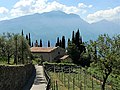
Tenno - Ville del Piano, Burg and Frapporta

Gothic pointed arch gate Frapporta

Tenno Island

Varone waterfall
San Lorenzo Church

Canal

San Antonio Abate Ville del Monte

Carne Salada


Culinary specialties
Tenno, along with Arco and Varone, is the region of origin of the traditional Trentino meat dish Carne Salada .
literature
- Giulia Anzilotti Mastrelli: Toponomastica trentina: i nomi delle località abitate Provincia Autonoma di Trento, Trento 2003. ISBN 88-7702-088-1
- Aldo Gorfer: Le Valli del Trentino. Trentino Occidentale , Manfrini, Calliano 1975.
- Sara Retrosi, Chiara Tozzi (ed.): Guide del Trentino. Valle dei Laghi e Alto Garda , Temi, Trento 2007, ISBN 88-89706-07-4
Web links
- Tenno on www.comuni-italiani.it (Italian)
Individual evidence
- ↑ Statistiche demografiche ISTAT. Monthly population statistics of the Istituto Nazionale di Statistica , as of December 31 of 2019.
- ↑ Municipal statute in Italian (PDF; 296 kB), accessed on June 16, 2017.
- ↑ Aldo Gorfer: Le Valli del Trentino. Trentino Occidentale p. 239
- ^ Giulia Anzilotti Mastrelli: Toponomastica trentina: i nomi delle località abitate, pp. 134-135
- ^ Sara Retrosi, Chiara Tozzi (ed.): Guide del Trentino. Valle dei Laghi e Alto Garda pp. 263-264
- ↑ Aldo Gorfer: Le Valli del Trentino. Trentino Occidentale p. 243

Ala | Albiano | Aldeno | Altavalle | Altopiano della Vigolana | Amblar-Don | Andalo | Arco | Avio | Baselga di Piné | Bedollo | Besenello | Bieno | Bleggio Superiore | Bocenago | Bondone | Borgo Chiese | Borgo d'Anaunia | Borgo Lares | Borgo Valsugana | Brentonico | Bresimo | Caderzone Terme | Calceranica al Lago | Caldes | Caldonazzo | Calliano | Campitello di Fassa | Campodenno | Canal San Bovo | Canazei | Capriana | Carisolo | Carzano | Castel Condino | Castel Ivano | Castello Tesino | Castello-Molina di Fiemme | Castelnuovo | Cavalese | Cavareno | Cavedago | Cavedine | Cavizzana | Cembra Lisignago | Cimone | Cinte Tesino | Cis | Civezzano | Cles | Comano Terme | Commezzadura | Contà | Dambel | Denno | Dimaro Folgarida | Drena | Dro | Fai della Paganella | Fiavé | Florutz | Folgaria | Fornace | Garniga Terme | Repented | Giovo | Giustino | Grigno | Imer | Isera | Lavarone | Lavis | Ledro | Levico Terme | Livo | Lona-Lases | Lusern | Madruzzo | Malè | Massimeno | Mazzin | Mezzana | Mezzano | Mezzocorona | Mezzolombardo | Moena | Molveno | Mori | Nago-Torbole | Nogaredo | Nomi | Novaledo | Novella | Ospedaletto | Ossana | Palù del Fersina | Panchià | Peio | Pellizzano | Pelugo | Pergine Valsugana | Pieve Tesino | Pieve di Bono-Prezzo | Pinzolo | Pomarolo | Porte di Rendena | Predaia | Predazzo | Primiero San Martino di Castrozza | Rabbi | Riva del Garda | Romeno | Roncegno Terme | Ronchi Valsugana | Ronzo-Chienis | Ronzone | Rovereto | Roverè della Luna | Ruffrè-Mendola | Rumo | Sagron Mis | Samone | San Giovanni di Fassa | San Lorenzo Dorsino | San Michele all'Adige | Sant'Orsola Terme | Sanzeno | Sarnonico | Scurelle | Segonzano | Sella Giudicarie | Sfruz | Soraga di Fassa | Sover | Spiazzo | Spormaggiore | Sporminors | Stenico | Storo | Strembo | Telve | Telve di Sopra | Tenna | Tenno | Terragnolo | Terre d'Adige | Terzolas | Tesero | Tione di Trento | Sound | Torcegno | Trambileno | Tre Ville | Trento | Valdaone | Valfloriana | Vallarsa | Vallelaghi | Vermiglio | Vignola-Falesina | Villa Lagarina | Ville d'Anaunia | Ville di Fiemme | Volano | Ziano di Fiemme