
Frozen Wall Spikes
| Frozen Wall Spikes | ||
|---|---|---|
 The northern summit of the Gefrorene-Wand-Spitzen from the Durrachjöchl viewed from the northwest |
||
| height | 3288 m above sea level A. | |
| location | Tyrol , Austria | |
| Mountains | Zillertal Alps | |
| Dominance | 1.9 km → Olperer | |
| Notch height | 258 m ↓ Riepensattel | |
| Coordinates | 47 ° 3 '54 " N , 11 ° 40' 44" E | |
|
||
| rock | Granite gneiss | |
| First ascent | North Summit 1867 by a Dr. Berreitter , southern summit on September 7, 1872 by Max and Richard von Frey | |

The Gefrorene-Wand-Spitzen are two peaks in the Tuxer Kamm , a mountain range in the Zillertal Alps in the Austrian state of Tyrol . The north summit is 3288 m above sea level. A. high, the south summit 3270 m . The tips are about 300 meters apart. Seen from the north, they appear as a truncated conical firn-covered cathedral, from the east, however, as a repelling, dark wall. To the northeast and southwest, they send pronounced ridges that mark the course of the ridge. The peaks are the highest points of the Hintertux Glacier summer ski area and have been accessible from Hintertux by aerial cable cars and lifts since the late 1990s , making them a popular destination for day-trippers. The northern tip was first climbed in 1867 by a Dr. Berreitter , the southern tip first climbed on September 7, 1872, the brothers Max and Richard von Frey from Salzburg.
Surroundings
The Frozen Wall Peaks are surrounded by glaciers . In the west, the extended Gefrorene-Wand-Kees reaches up to the peaks, in the south-west the Großer Riepenkees extends to over 3000 meters, in the north-east is the small Friesenbergkees and in the south-east the Kleiner Riepenkees . Neighboring mountains are in the course of the northeast ridge , separated by the Friesenbergscharte located at 2904 meters above sea level , the 3231 meter high Riffler , in the course of the southwest ridge , separated by the wide Riepensattel of the Olperer , at 3,476 meters the highest peak of the Tuxer Kamm. To the northwest, the terrain slopes down to the Tuxer Tal, to the southeast into the Zamser Grund . An important place in the north is Hintertux, about 6 kilometers away as the crow flies . The Finkenberg district of Ginzling is just under 11 kilometers to the east.
Bases and routes
If you want to climb the Gefrorenen-Wand-Spitzen alpine, i.e. without technical ascent aids, you can use the normal route from the Spannagelhaus , at an altitude of 2531 meters , as the easiest climb . This path leads in a southerly direction ( Wildlahnerscharte ) to the Gefrorene-Wand-Kees with its ski runs. The route then runs over the north-west ridge of the north summit using easy climbing at UIAA I level to the highest point, while the south summit requires a moderately difficult climb at UIAA grade II. According to literature, the walking time is 2½ hours. From the Friesenberghaus (2498 m) an inspection from the east is possible. Here the route initially follows the Berliner Höhenweg to the point where it turns at right angles to the west of the hut to the south ( altitude point 2600 m). Then it goes west over the firn field of the Friesenbergkees up to the northeast ridge of the north summit in a walking time of about 3 hours. From the mountain station of the Hintertux Glacier Cable Car, the north summit can be reached in about 15 minutes over easy terrain.
gallery

View from the north summit to the south
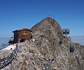
View from the panorama terrace to the north summit and the Gletscherbus 3 cable car

View from a gondola of the Gletscherbus 3 cable car to the south to the mountain station with a panoramic terrace. Behind it the south summit
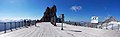
On the panorama terrace with a view of the south summit, on the right the Olperer


Literature and map
- Heinrich Klier, Walter Klier : Alpine Club Guide Zillertal Alps. Bergverlag Rother, Munich 1996, ISBN 3-7633-1269-2 .
- Eduard Amthor (ed.): The alpine friend. Monthly booklets for the dissemination of alpine studies among young and old in popular and entertaining descriptions from the entire area of the alpine world and with practical waves for enjoyable tours of the same. Gera 1870, p. 245.
- Alpine Club Map 1: 25,000, sheet 35/1, Zillertal Alps, western sheet
Web links
Individual evidence
- ^ Federal Office for Metrology and Surveying Austria: Austrian Map online (Austrian map 1: 50,000) .
- ↑ Eduard Richter (Ed.): The development of the Eastern Alps. Volume III: The Central Alps east of the Brenner and the southern Limestone Alps. Publisher of the German and Austrian Alpine Club, Berlin 1894, OCLC 310809628 , p. 101.