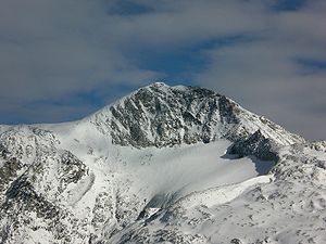
Hoher Riffler (Zillertal Alps)
| High Riffler | ||
|---|---|---|
|
Hoher Riffler with Friesenbergsee and Friesenberghaus as well as Petersköpfl (2020) |
||
| height | 3231 m above sea level A. | |
| location | Tyrol , Austria | |
| Mountains | Zillertal Alps | |
| Dominance | 2.6 km → Frozen wall peaks | |
| Notch height | 321 m ↓ Friesenbergscharte | |
| Coordinates | 47 ° 4 '53 " N , 11 ° 42' 15" E | |
|
|
||
| First ascent | 1864 on the occasion of the national survey | |
| Normal way | Southwest ridge ( I ) | |
|
The summit structure of the Hohen Riffler from the west, in front of it the Schwarzbrunnerkees |
||
The Hohe Riffler is a 3231 m above sea level. A. high mountain in the Zillertal Alps , in the east of the Tuxer Kamm , in the Austrian state of Tyrol . The mountain is covered with firn on its northern side , from the south it appears as a rocky peak. To the south-west, north, north-east and south-east, the mountain sends pronounced ridges, some of which carry the ascent paths. The mountain is easy to reach from the Spannagelhaus mountain restaurant to the west and the Friesenberghaus refuge to the south and is therefore often visited. In winter it is an easy destination for ski mountaineers . It was first climbed on the occasion of the Austrian national survey. First tourist was, according to the literature, an H. Weber, conducted by Georg Samer in 1875. Members of the KÖHV Leopoldina Innsbruck built 1981/82 an iron cross on the summit with the coat of arms of the connection .
Surroundings
The Zillertal Riffler is only surrounded by glaciers in the north and west . In the north the Federbettkees extends to just below the summit, and in the west lies the significantly smaller Schwarzbrunnerkees . In the southeast, the remains of the Rifflerkee are still present, which has declined sharply in the course of global warming . Adjacent mountains are in the course of the southwest ridge , separated by the Friesenbergscharte at an altitude of 2910 m , the Gefrorene-Wand -spitze at 3288 m , on the other side of the Federbettkees, along the north ridge , which turns to the northeast, separated by the Obere Rifflerscharte ( 2868 m ), Grierer-Kar -spitze ( 2952 m ), Napfspitze (2925 m) and the 3039 m high Realspitze . In the course of the southeast ridge , above the Wesendlekarsee (water level at 2375 m), separated by the Untere Rifflerscharte at 2774 meters above sea level, lies the Kleine Riffler ( 2837 m ). The next significant settlement is the winter sports resort of Hintertux, about four kilometers to the north-west as the crow flies .
Bases and routes
The base for ice-free ascent over the south ridge is the Friesenberghaus at 2498 m , over the Friesenbergscharte and south-west ridge it is the Spannagelhaus . Both routes are roughly the same in their difficulty level UIAA I and are considered normal routes , but only the variant over the south ridge from the Friesenberghaus is marked as an alpine route. On the south ridge, there are often snowfields above around 3,000 meters up into midsummer. According to literature, walking time from the Friesenberghaus is around two and a half hours, from the Spannagelhaus it is a little shorter to the summit cross . In winter, an ascent is also possible as an easy ski tour in safe conditions (danger of avalanches) via Schwarzbrunnerkees.
Individual evidence
- ^ Federal Office for Metrology and Surveying Austria: Austrian Map online (Austrian map 1: 50,000) .
- ↑ Peter Krause : O old lad glory. The students and their customs. 5th edition. Graz, Vienna, Cologne 1997, p. 214.
Literature and map
- Heinrich Klier / Walter Klier : Alpine Club Guide Zillertal Alps , Munich 1996, ISBN 3-7633-1269-2
- Alpine Club Map 1: 25,000 Zillertal Alps, West , sheet 35/1


