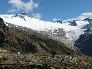
Schwarzensteinkees
| Schwarzensteinkees | ||
|---|---|---|
|
Schwarzensteinkees with Schwarzenstein |
||
| location | Tyrol , Austria | |
| Mountains | Zillertal Alps | |
| length | 2.5 km | |
| surface | 4.118 km² | |
| Exposure | northwest | |
| Altitude range | 3320 m above sea level A. - 2319 m above sea level A. | |
| Coordinates | 47 ° 0 '52 " N , 11 ° 51' 32" E | |
|
|
||
| drainage | Zemmbach → Ziller → Inn | |
The Schwarzensteinkees is a glacier in the Zillertal Alps in Tyrol .
It extends at the end of the Zemmgrund valley below the Schwarzenstein ( 3369 m above sea level ) and the III. Hornspitze ( 3254 m above sea level ) over an altitude range of around 3300 to 2300 m from the main Alpine ridge to the northwest. The horn ridge separates the Schwarzensteinkees from the neighboring Hornkees to the west . With an area of around 4 km², the Schwarzensteinkees is one of the largest glaciers in the Zillertal Alps. It drains over the Zemmbach to the Ziller .

Like most glaciers in the Alps, the Schwarzensteinkees has been affected by the melting of the glaciers since the middle of the 19th century . In 1850 its area was 7.20 km², since then the glacier has lost over 40% of its area. In 2011 the lower edge of the tongue was torn off, it no longer has any connection with the main glacier. This development was interrupted by significant advances in the years 1972 to 1990. The Schwarzensteinkees was often the Austrian glacier with the largest measured increase in length (1978/79: +44 m, 1979/80: +78 m).
Web links
Notes and individual references
- ^ A b c World Glacier Monitoring Service (WGMS): Fluctuations of Glaciers 2005–2010 (Vol. X). Zurich 2012, p. 119 ( PDF; 5 MB ( Memento of the original from March 5, 2014 in the Internet Archive ) Info: The archive link has been inserted automatically and has not yet been checked. Please check the original and archive link according to the instructions and then remove this notice. )
- ↑ Today the stream is called Zemmbach, the origin of the Ziller is seen in the Zillergrund .
- ↑ Peter Pindur, Helmut Heuberger: On the Holocene glacier history in the Zemmgrund in the Zillertal Alps, Tyrol / Austria (Eastern Alps). In: Journal of Glacier Science and Glacial Geology. Volume 42, No. 2, 2008, pp. 21-89 ( online ).
- ↑ Andrea Fischer : Glacier Report 2011/2012. Collective report on the glacier measurements of the Austrian Alpine Club in 2012. In: Bergauf. No. 2, 2013, pp. 22–28 ( PDF; 590 kB ).
- ↑ Andrea Fischer, Gernot Patzelt, Hans Kinzl: Length changes of Austrian glaciers 1969-2013. Institute for Interdisciplinary Mountain Research of the Austrian Academy of Sciences, Innsbruck 2013, doi : 10.1594 / PANGEA.821823

