
Stilluppbach
|
Stilluppbach Stillupbach, still doll |
||
 Stilluppbach origin |
||
| Data | ||
| Water code | AT : 2-8-214-40-38 | |
| location | Stilluppgrund , Tyrol , Austria | |
| River system | Danube | |
| Drain over | Zemmbach → Ziller → Inn → Danube → Black Sea | |
| origin | Eastern Stillupkees 47 ° 3 ′ 0 ″ N , 11 ° 57 ′ 45 ″ E |
|
| Source height | 2488 m above sea level A. | |
| muzzle | between Gstan and Mayrhofen in the Zemmbach Coordinates: 47 ° 9 '40 " N , 11 ° 50' 50" E 47 ° 9 '40 " N , 11 ° 50' 50" E |
|
| Mouth height | 636 m above sea level A. | |
| Height difference | 1852 m | |
| Bottom slope | 10% | |
| length | 17.7 km | |
| Catchment area | 72.9 km² | |
| Reservoirs flowed through | Memory Stillupp | |
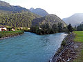
The Stilluppbach , also known as the Stilluppe , is a right tributary of the Zemmbach in the Zillertal Alps in Tyrol.
course
The Stilluppbach arises from several spring streams in the Gfaller Grund basin at around 1900 m above sea level. A. The stream is fed all year round by the meltwater of the Lapenkees (altitude 2600–2900 m), Löfflerkees (altitude 2300–2900 m), western Stillupkees (altitude 2300–2900 m) and eastern Stillupkees (altitude 2500–3000 m). The longest spring stream rises from the eastern Stillupkees. The Stilluppbach flows in a north-easterly direction through the Stilluppgrund and flows into the Zemmbach between Finkenberg and Mayrhofen , which in turn flows into the Ziller about a kilometer further .
Memory Stillupp
The water from the creek is used to generate electricity and is dammed in the Stillupp reservoir. Water from neighboring valleys and reservoirs is also fed into this reservoir via pressure tunnels . A 4.5 km long pressure tunnel guides the water from the Stillupp reservoir to the power station in Mayrhofen .
The 450 m long dam of the Stillupp reservoir was built 5.3 km upstream of the estuary, the dam floods the Stillupgrund over a length of 2.5 km.
Shortly before it flows into the Zemmbach, the Mayrhofen power plant drains into the Stilluppbach, so that it carries considerable amounts of water over the last few meters.

Estuary into the reservoir

Outflow from the Mayrhofen power plant (left) into the Stilluppbach (right)
The mouth of the Stilluppbach (left) into the Zemmbach


Web links
supporting documents
- ↑ a b c TIRIS - Tyrolean spatial information system
- ↑ Map: National water management plan, ecological status - Tyrol ( page no longer available , search in web archives ) Info: The link was automatically marked as defective. Please check the link according to the instructions and then remove this notice. (PDF file; 3.16 MB)
- ↑ Alpine Club Card 35/2: Zillertal Alps - Central (1: 25,000). 7th edition 2008.